Poplar River (Lost River tributary)

Last updated
Poplar River
Country United States
Physical characteristics
Main source Minnesota

The Poplar River is a 58.4-mile-long (94.0 km) [1] tributary of the Lost River of western Minnesota in the United States. Via the Lost River, the Clearwater River, the Red Lake River, the Red River of the North, Lake Winnipeg, and the Nelson River, it is part of the Hudson Bay watershed.

Minnesota State of the United States of America

Minnesota is a state in the Upper Midwest, Great Lakes, and northern regions of the United States. Minnesota was admitted as the 32nd U.S. state on May 11, 1858, created from the eastern half of the Minnesota Territory. The state has a large number of lakes, and is known by the slogan the "Land of 10,000 Lakes". Its official motto is L'Étoile du Nord.

United States Federal republic in North America

The United States of America (USA), commonly known as the United States or America, is a country comprising 50 states, a federal district, five major self-governing territories, and various possessions. At 3.8 million square miles, the United States is the world's third or fourth largest country by total area and is slightly smaller than the entire continent of Europe's 3.9 million square miles. With a population of over 327 million people, the U.S. is the third most populous country. The capital is Washington, D.C., and the largest city by population is New York City. Forty-eight states and the capital's federal district are contiguous in North America between Canada and Mexico. The State of Alaska is in the northwest corner of North America, bordered by Canada to the east and across the Bering Strait from Russia to the west. The State of Hawaii is an archipelago in the mid-Pacific Ocean. The U.S. territories are scattered about the Pacific Ocean and the Caribbean Sea, stretching across nine official time zones. The extremely diverse geography, climate, and wildlife of the United States make it one of the world's 17 megadiverse countries.

Red Lake River river in the United States of America

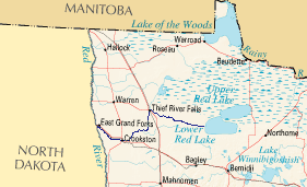
The Red Lake River is a river located in northwestern Minnesota. The river begins on the western side of the Lower Red Lake and flows westward. After passing through Thief River Falls, Red Lake Falls, and Crookston, the river merges with the Red River of the North in East Grand Forks. The total length of the river is 193 miles (310.6 km). The term "Forks" in Grand Forks comes from this forking (confluence) of the Red and Red Lake rivers near downtown Grand Forks.

The river's name comes from the Ojibwe Indians of the area, on account of the poplar trees near the river. [2]

Ojibwe group of indigenous peoples in North America

The Ojibwe, Ojibwa, Chippewa, or Saulteaux are an Anishinaabe people of Canada and the United States. They are one of the most numerous indigenous peoples north of the Rio Grande. In Canada, they are the second-largest First Nations population, surpassed only by the Cree. In the United States, they have the fifth-largest population among Native American peoples, surpassed in number only by the Navajo, Cherokee, Choctaw and Sioux.

<i>Populus</i> genus of plants

Populus is a genus of 25–35 species of deciduous flowering plants in the family Salicaceae, native to most of the Northern Hemisphere. English names variously applied to different species include poplar, aspen, and cottonwood.

See also

Coordinates: 47°50′08″N96°04′35″W / 47.8355197°N 96.0764263°W / 47.8355197; -96.0764263 [3]

Geographic coordinate system Coordinate system

A geographic coordinate system is a coordinate system that enables every location on Earth to be specified by a set of numbers, letters or symbols. The coordinates are often chosen such that one of the numbers represents a vertical position and two or three of the numbers represent a horizontal position; alternatively, a geographic position may be expressed in a combined three-dimensional Cartesian vector. A common choice of coordinates is latitude, longitude and elevation. To specify a location on a plane requires a map projection.

Related Research Articles

Buffalo River (Minnesota) river in Minnesota, United States of America

The Buffalo River is a 139-mile-long (224 km) tributary of the Red River of the North in western Minnesota in the United States. Via the Red River, Lake Winnipeg and the Nelson River, it is part of the watershed of Hudson Bay. The river drains an area of 1,189 square miles (3,080 km2).

Sand Hill River river in the United States of America

The Sand Hill River is a 101-mile-long (163 km) tributary of the Red River of the North in northwestern Minnesota in the United States. Via the Red River, Lake Winnipeg, and the Nelson River, it is part of the watershed of Hudson Bay, and drains an area of 475 square miles (1,230 km2).

The Black River is a 33.7-mile-long (54.2 km) tributary of the Red Lake River of Minnesota in the United States. Via the Red Lake River, the Red River of the North, Lake Winnipeg, and the Nelson River, it is part of the Hudson Bay watershed.

The Blackduck River is a 33.2-mile-long (53.4 km) tributary of Red Lake in northwestern Minnesota in the United States.

The Clearwater River is a 147-mile-long (237 km) tributary of the Red Lake River of Minnesota in the United States. Via the Red Lake River, the Red River of the North, Lake Winnipeg, and the Nelson River, it is part of the Hudson Bay watershed.

The Cross River is a 20.4-mile-long (32.8 km) river in northern Minnesota, the United States. It is a direct tributary of Lake Superior.

Devil Track River river in the United States of America

The Devil Track River is an 8.7-mile-long (14.0 km) river in northeastern Minnesota, the United States. It begins at the outlet of Devil Track Lake and flows southeast to Lake Superior east of Croftville.

The Gentilly River is an 8.5-mile-long (13.7 km) tributary of the Red Lake River of Minnesota in the United States. Via the Red Lake River, the Red River of the North, Lake Winnipeg, and the Nelson River, it is part of the Hudson Bay watershed.

The Hill River is a 60.8-mile-long (97.8 km) tributary of the Lost River of western Minnesota in the United States. Via the Lost River, the Clearwater River, the Red Lake River, the Red River of the North, Lake Winnipeg, and the Nelson River, it is part of the Hudson Bay watershed.

The Little Black River is a 4.5-mile-long (7.2 km) river in Wylie Township, in northwestern Red Lake County, Minnesota. From its source — Goose Lake Swamp in the Pembina State Wildlife Management Area — the river runs south and southeast to the Black River, a tributary of the Red Lake River. Its waters ultimately drain via Canada's Nelson River into Hudson Bay.

The Lost River is a 76.2-mile-long (122.6 km) tributary of the Clearwater River of northwestern Minnesota in the United States. Via the Clearwater River, the Red Lake River, the Red River of the North, Lake Winnipeg, and the Nelson River, it is part of the watershed of Hudson Bay.

Marsh River (Minnesota) river in the United States of America

The Marsh River, located in Minnesota, is a 49.9-mile-long (80.3 km) tributary of the Red River of the North. It rises less than 600 feet (180 m) from the Wild Rice River, east of the city of Ada, and flows generally northwest, entering the Red River 2 miles (3 km) northwest of Shelly. The Marsh River flows entirely within Norman County.

The Mud River is a 23.1-mile-long (37.2 km) tributary of Red Lake in northwestern Minnesota in the United States.

The Mud River is a 21.0-mile-long (33.8 km) stream of northwestern Minnesota in the United States. It flows from a point east of Grygla westwards to the Agassiz National Wildlife Refuge and the large wetlands complex surrounding Agassiz Pool. It is part of the Thief River watershed, which drains via the Red Lake River, the Red River of the North, Lake Winnipeg, and the Nelson River to Hudson Bay.

The North Cormorant River is a 39.1-mile-long (62.9 km) tributary of the Blackduck River of Minnesota in the United States. It joins the Blackduck River shortly upstream of that river's mouth at Red Lake, the largest natural lake entirely within Minnesota.

The Rabbit River is a 31.5-mile-long (50.7 km) tributary of the Bois de Sioux River of Minnesota in the United States. Via the Bois de Sioux River, Red River of the North, Lake Winnipeg, and the Nelson River, it is part of the Hudson Bay watershed.

The Sandy River is a 28.8-mile-long (46.3 km) tributary of Red Lake in northwestern Minnesota in the United States.

The Tait River is a 12.8-mile-long (20.6 km) river in northeastern Minnesota, the United States. It is a tributary of the Poplar River.

Twelvemile Creek is a 55.1-mile-long (88.7 km) tributary of the Mustinka River of Minnesota in the United States. It rises in Stevens County and flows northwest before joining the Mustinka in Traverse County. Via the Mustinka and Bois de Sioux rivers, the Red River of the North, Lake Winnipeg, and the Nelson River, it is part of the Hudson Bay watershed.

The White Earth River is a 26.2-mile-long (42.2 km) tributary of the Wild Rice River of northwestern Minnesota in the United States. Via the Wild Rice River, the Red River of the North, Lake Winnipeg, and the Nelson River, it is part of the Hudson Bay watershed. It rises at the outlet of White Earth Lake and flows northwest through Mahnomen County, joining the Wild Rice River just east of the city of Mahnomen.

References

  1. U.S. Geological Survey. National Hydrography Dataset high-resolution flowline data. The National Map, accessed June 8, 2011
  2. Upham, Warren (1920). Minnesota Geographic Names: Their Origin and Historic Significance. Minnesota Historical Society. p. 447.
  3. U.S. Geological Survey Geographic Names Information System: Poplar River