The Caribbean Sea is a sea of the Atlantic Ocean in the tropics of the Western Hemisphere. It is bounded by Mexico and Central America to the west and southwest, to the north by the Greater Antilles starting with Cuba, to the east by the Lesser Antilles, and to the south by the northern coast of South America. The Gulf of Mexico lies to the northwest.

Surfing is a surface water sport in which an individual, a surfer, uses a board to ride on the forward section, or face, of a moving wave of water, which usually carries the surfer towards the shore. Waves suitable for surfing are primarily found on ocean shores, but can also be found in standing waves in the open ocean, in lakes, in rivers in the form of a tidal bore, or in wave pools.

Manzanillo is a city and seat of Manzanillo Municipality, in the Mexican state of Colima. The city, located on the Pacific Ocean, contains Mexico's busiest port, responsible for handling Pacific cargo for the Mexico City area. It is the largest-producing municipality for the business sector and tourism in the small state of Colima.

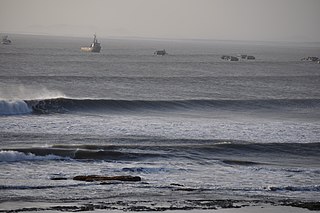
A rip current is a specific type of water current that can occur near beaches where waves break. A rip is a strong, localized, and narrow current of water that moves directly away from the shore by cutting through the lines of breaking waves, like a river flowing out to sea. The force of the current in a rip is strongest and fastest next to the surface of the water.

Guanacaste is a province of Costa Rica located in the northwestern region of the country, along the coast of the Pacific Ocean. It is bordered by Nicaragua to the north, Alajuela Province to the east, and Puntarenas Province to the southeast. It is the most sparsely populated of all the provinces of Costa Rica. The province covers an area of 10,141 square kilometres (3,915 sq mi) and as of 2010, had a population of 354,154, with annual revenue of $2 billion.

Buxton is an unincorporated community and census-designated place (CDP) on Hatteras Island near Cape Hatteras. It is located in Dare County in the U.S. state of North Carolina. As of the 2010 census, it had a population of 1,273. Located at the widest part of Hatteras Island, it is the largest community on Hatteras Island both in terms of area and population, and is home to the island's schools and other major public buildings and offices.

Hurricane Fico was the longest-lived hurricane of the 1978 Pacific hurricane season and became the longest-lasting Pacific hurricane on record, a record broken by Hurricane Tina fourteen years later. The sixth tropical storm, fourth hurricane, and third major hurricane, Fico developed from a tropical disturbance off the Pacific coast of Mexico on July 9. It moved northwestward and then westward, quickly reaching peak winds of 140 mph (230 km/h) on July 12. Moving nearly due westward, the intensity of Fico fluctuated from Category 1 to Category 4 status on the Saffir–Simpson hurricane scale for the following days, and it passed about 170 miles (270 km) south of Hawaii on July 20 with winds of 115 mph (185 km/h). Fico slowly weakened as it turned to the northwest over cooler waters, and became an extratropical cyclone on July 28 to the northeast of Midway Island.

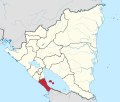
San Juan del Sur is a municipality and coastal town on the Pacific Ocean, in the Rivas department in southwest Nicaragua. It is located 140 kilometres (87 mi) south of Managua. San Juan del Sur is popular among surfers and is a vacation spot for many Nicaraguan families and foreign tourists.
G-Land, also known as Plengkung Beach, is an internationally renowned surf break on Grajagan Bay, Banyuwangi, Alas Purwo National Park, East Java, Indonesia, about half a day by road from the popular tourist destinations of Bali. It is most commonly reached via boat charter from Bali.
Malabrigo also called unofficially Puerto Chicama, is a port and small coastal city in northwestern Peru, located in La Libertad Region, some 70 km north of Trujillo city. The town is home to the Chicama wave, the first legally protected wave in the world, as well as the world's longest left-breaking wave—see External Links.
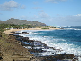
Sandy Beach, also referred to as "Sandy's" and known to Hawaiians as Wāwāmalu, is a beach on the southeastern shore of Oʻahu in Hawaii. It is known for its excellent bodyboarding and bodysurfing opportunities due to its peaky shore break and consistent barrels. Consequently, Sandy Beach has one of the highest incidences of water related spinal cord injuries in Hawaii, earning it the infamous nickname, "break-neck" beach. The water is especially dangerous during high surf, when powerful waves break over shallow sand and slabs of underwater lava rock. In certain conditions, strong rip currents are also present. The beach park is located between Hanauma Bay Nature Preserve to the west and Makapuʻu Point to the east along Kalanianaʻole Highway.

The climate of Los Angeles is mild to hot year-round, and mostly dry. It is classified as a Mediterranean climate, which is a type of subtropical climate. It is characterized by seasonal changes in rainfall—with a dry summer and a winter rainy season. Under the Köppen climate classification, the coastal areas are classified as Csb, and the inland areas as Csa.

A surf break is a permanent obstruction such as a coral reef, rock, shoal, or headland that causes a wave to break, forming a barreling wave or other wave that can be surfed, before it eventually collapses. The topography of the seabed determines the shape of the wave and type of break. Since shoals can change size and location, affecting the break, it takes commitment and skill to find good breaks. Some surf breaks are quite dangerous, since the surfer can collide with a reef or rocks below the water.

Sidi Kaouki is a small town located 25 km south of Essaouira. It is a rural commune in Essaouira Province of the Marrakech-Tensift-Al Haouz region of Morocco. At the time of the 2004 census, the commune had a total population of 4335 people living in 902 households.

Uluwatu is a region on the south-western tip of the Bukit Peninsula of Bali, Indonesia. It is home to the Pura Luhur Uluwatu Temple.

The marine ecoregions of the South African exclusive economic zone are a set of geographically delineated regions of similar ecological characteristics on a fairly broad scale, covering the exclusive economic zone along the South African coast.
An earthquake occurred on 26 August 2012 at 22:37 local time. The earthquake located off the coast of El Salvador measured 7.3 on the moment magnitude scale and had a focal depth of 16.0 kilometres (10 mi). No deaths were reported, however more than 40 people were injured when they were caught in a tsunami generated by the earthquake. Waves from the tsunami were unusually large for an earthquake of this size. The large waves were attributed to the earthquake's unique rupture characteristic. In addition to the absence of fatalities, damage caused by the earthquake and tsunami was minimal as a result of the sparse population around the affected region and the slow rupture characteristic of the event.

Hurricane Enrique was a Category 1 Pacific hurricane that brought heavy rainfall and flooding to much of western Mexico in late June 2021. The fifth named storm and first hurricane of the 2021 Pacific hurricane season, Enrique developed from a tropical wave the entered the Pacific Ocean off the coast of Nicaragua on June 22. In an environment conducive for intensification, the disturbance moved west-northwestward and developed into a tropical storm by 6:00 UTC on June 25, as it was already producing winds of 40 mph (65 km/h), and received the name Enrique. Enrique strengthened steadily within an environment of warm waters and low-to-moderate wind shear while continuing its northwestward motion. By 12:00 UTC on June 26, Enrique had intensified into a Category 1 hurricane as the storm turned more northwestward. Nearing the coast of Mexico, Enrique reached its peak intensity around 6:00 UTC the following day, with maximum sustained winds of 90 mph (150 km/h) and a minimum barometric pressure of 972 mbar (28.7 inHg). Enrique, passing closely offshore west-central Mexico, maintained its intensity for another 24 hours as it turned northward toward the Gulf of California. Turning back to the northwest on June 28, increasing wind shear and dry air caused the hurricane to weaken. Enrique dropped to tropical storm status at 18:00 UTC that day, and further weakened to a tropical depression on June 30 just to the northeast of Baja California. The depression was absorbed into a larger low pressure area to the southeast later that day.
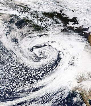
An extremely powerful extratropical bomb cyclone began in late October 2021 in the Northeast Pacific and struck the Western United States and Western Canada. The storm was the third and the most powerful cyclone in a series of powerful storms that struck the region within a week. The cyclone tapped into a large atmospheric river and underwent explosive intensification, becoming a bomb cyclone on October 24. The bomb cyclone had a minimum central pressure of 942 millibars (27.8 inHg) at its peak, making it the most powerful cyclone recorded in the Northeast Pacific. The system had severe impacts across Western North America, before dissipating on October 26. The storm shattered multiple pressure records across parts of the Pacific Northwest. Additionally, the bomb cyclone was the most powerful storm on record to strike the region, in terms of minimum central pressure. The bomb cyclone brought powerful gale-force winds and flooding to portions of Western North America. At its height, the storm cut the power to over 370,500 customers across the Western U.S. and British Columbia. The storm killed at least two people; damage from the storm was estimated at several hundred million dollars. The bomb cyclone was compared to the Columbus Day Storm of 1962, in terms of ferocity.