
Plovdiv Stadium, formerly known as 9th September Stadium, is a multi-purpose stadium in Plovdiv, Bulgaria. It is currently used mostly for athletics championships. The stadium holds 55,000. The stadium was built in 1950.
Stadion Sportkompleks Abdysh-Ata is a multi-use stadium in Kant, Kyrgyzstan. It is currently used mostly for football matches and serves as the home stadium for Abdish-Ata Kant of the Kyrgyzstan League. The stadium has a capacity of 3,000 people.

Ramułtowice is a village in the administrative district of Gmina Kostomłoty, within Środa Śląska County, Lower Silesian Voivodeship, in south-western Poland. Prior to 1945 it was in Germany. It lies approximately 10 kilometres (6 mi) north-east of Kostomłoty, 12 km (7 mi) south-east of Środa Śląska, and 23 km (14 mi) west of the regional capital Wrocław.

Bazum is a village in the Lori Province of Armenia.
Alfonsów is a village in the administrative district of Gmina Wodzierady, within Łask County, Łódź Voivodeship, in central Poland. It lies approximately 2 kilometres (1 mi) east of Wodzierady, 16 km (10 mi) north of Łask, and 23 km (14 mi) west of the regional capital Łódź.

Əli Bayramlı is a village in the Qakh Rayon of Azerbaijan.
Witów is a village in the administrative district of Gmina Warta, within Sieradz County, Łódź Voivodeship, in central Poland. It lies approximately 6 kilometres (4 mi) north-west of Warta, 19 km (12 mi) north-west of Sieradz, and 63 km (39 mi) west of the regional capital Łódź.
Gawerków is a village in the administrative district of Gmina Żelechlinek, within Tomaszów Mazowiecki County, Łódź Voivodeship, in central Poland. It lies approximately 3 kilometres (2 mi) east of Żelechlinek, 23 km (14 mi) north of Tomaszów Mazowiecki, and 42 km (26 mi) east of the regional capital Łódź.

Dobra is a village in the administrative district of Gmina Stryków, within Zgierz County, Łódź Voivodeship, in central Poland. It lies approximately 6 kilometres (4 mi) south-west of Stryków, 10 km (6 mi) east of Zgierz, and 12 km (7 mi) north-east of the regional capital Łódź.
Pisarzówka is a village in the administrative district of Gmina Biecz, within Gorlice County, Lesser Poland Voivodeship, in southern Poland. It lies approximately 5 kilometres (3 mi) west of Biecz, 9 km (6 mi) north of Gorlice, and 99 km (62 mi) southeast of the regional capital Kraków.
Zalesie is a village in the administrative district of Gmina Raków, within Kielce County, Świętokrzyskie Voivodeship, in south-central Poland. It lies approximately 6 kilometres (4 mi) north of Raków and 37 km (23 mi) south-east of the regional capital Kielce.
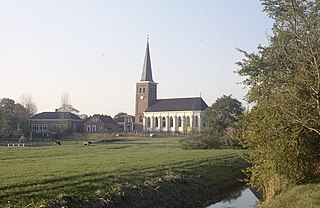
Mantgum is a small village in Leeuwarden municipality in the province Friesland of the Netherlands and had around 1,172 citizens in January 2017.
Drzeniów is a village in the administrative district of Gmina Tuplice, within Żary County, Lubusz Voivodeship, in western Poland.
Kiełpinek is a village in the administrative district of Gmina Człuchów, within Człuchów County, Pomeranian Voivodeship, in northern Poland. It lies approximately 8 kilometres (5 mi) north of Człuchów and 110 km (68 mi) south-west of the regional capital Gdańsk.
Perlinko is a village in the administrative district of Gmina Gniewino, within Wejherowo County, Pomeranian Voivodeship, in northern Poland. It lies approximately 5 kilometres (3 mi) west of Gniewino, 24 km (15 mi) north-west of Wejherowo, and 60 km (37 mi) north-west of the regional capital Gdańsk.
Gulbity is a village in the administrative district of Gmina Pasłęk, within Elbląg County, Warmian-Masurian Voivodeship, in northern Poland. It lies approximately 7 kilometres (4 mi) north-east of Pasłęk, 21 km (13 mi) east of Elbląg, and 62 km (39 mi) north-west of the regional capital Olsztyn.
Międzybór is a village in the administrative district of Gmina Drawno, within Choszczno County, West Pomeranian Voivodeship, in north-western Poland. It lies approximately 11 kilometres (7 mi) south-east of Drawno, 32 km (20 mi) east of Choszczno, and 91 km (57 mi) east of the regional capital Szczecin.
Smólsko is a village in the administrative district of Gmina Nowogródek Pomorski, within Myślibórz County, West Pomeranian Voivodeship, in north-western Poland. It lies approximately 5 kilometres (3 mi) south of Nowogródek Pomorski, 13 km (8 mi) south-east of Myślibórz, and 68 km (42 mi) south-east of the regional capital Szczecin.

Püha is a village in Saaremaa Parish, Saare County in western Estonia.

Bjeljajci is a village in the municipality of Višegrad, Bosnia and Herzegovina.


