
San Luis Obispo County, officially the County of San Luis Obispo, is a county located in the southern region of the U.S. state of California. As of the 2010 census, the population was 269,637. The county seat is San Luis Obispo.

The Central Coast is an area of California, United States, roughly spanning the coastal region between Point Mugu and Monterey Bay. It lies northwest of Los Angeles County and south of San Francisco and San Mateo counties. Six counties make up the Central Coast: from south-to north, Ventura, Santa Barbara, San Luis Obispo, Monterey, San Benito, and Santa Cruz.

Cuesta College is a public community college in San Luis Obispo County, in the Central Coast region of California.
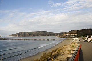
Avila Beach is an unincorporated community in San Luis Obispo County, California, United States, located on San Luis Obispo Bay about 160 miles (257 km) northwest of Los Angeles, and about 200 miles (320 km) south of San Francisco. For statistical purposes, the United States Census Bureau has defined Avila Beach as a census-designated place (CDP). The census definition of the area may not precisely correspond to local understanding of the area with the same name. The population was 1,627 at the 2010 census.

Cholame is an unincorporated community in San Luis Obispo County, California, USA. It sits within a mile of the San Andreas Rift Zone fault line at an elevation of 1,157 feet (353 m) above sea level and is located at 35°43′26″N120°17′44″W. Cholame is reached via State Route 41, just southwest of the junction of Route 46. Rainfall data from a nearby ranch shows that the area around Cholame only receives about eight to nine inches (200–230 mm) of rain in a normal year.

Estero Bay is a bay located on the Pacific Coast in San Luis Obispo County, central California. It is about 15 miles (24 km) from its south end at Point Buchon/Montana de Oro State Park, to its north end at Point Estero, which is about 5 miles (8 km) northwest of Cayucos. It is indented about 5 miles (8 km) into the California coast.
Camp San Luis Obispo is the original home of the California Army National Guard. It served as an Infantry Division Camp and Cantonment Area for the United States Army during World War II.
Sycamore Mineral Springs Resort is a resort located in San Luis Obispo County, California. It is located near Avila Beach. This resort is mostly known for its mineral springs, but also has several different activities.

The Point San Luis Lighthouse, also known as the San Luis Obispo Light Station, is the only surviving Prairie Victorian model lighthouse that remains in existence on the West Coast of the United States. It is on the National Register of Historic Places and is being refurbished by the Point San Luis Lighthouse Keepers, a volunteer group. The lighthouse is located near Avila Beach on the Central Coast of California.

KKJG is a commercial FM radio station that is licensed to San Luis Obispo, California and broadcasts to the San Luis Obispo County area. The station is owned by American General Media and airs a country music radio format. The KKJG studios and offices are located on Sacramento Road in San Luis Obispo and its transmitter is off TV Tower Road in Santa Margarita, California.
The Paso Robles Event Center is an entertainment complex located in Paso Robles, California. The site opened in 1946 for the annual "California Mid-State Fair".

Camp Roberts is a California National Guard post in central California, located on both sides of the Salinas River in Monterey and San Luis Obispo counties, now run by the California Army National Guard. It was opened in 1941 and is named after Corporal Harold W. Roberts, a World War I Medal of Honor recipient. Nearby communities include San Miguel, Heritage Ranch, Oak Shores, and Bradley, all unincorporated. The nearest incorporated city is Paso Robles. Camp Roberts is roughly 25 miles southeast of Fort Hunter Liggett.

The Pereira Octagon Barn of San Luis Obispo is a historically and culturally important structure on the Central Coast of California. It was built in 1906 by Henri LaFranchi, John Damaso, and a third, unknown man. Since there were no other octagonal barns in the area, the builders may have worked from patterns of octagonal construction in farm journals or catalogs.
Rancho San Miguelito was a 14,198-acre (57.46 km2) Mexican land grant in present-day San Luis Obispo County, California given in 1842 by Governor Juan Alvarado to Miguel Ávila, and an addition granted in 1846 by Governor Pio Pico. The grant extended along the Pacific coast, and included Point San Luis, San Luis Obispo Bay, and present day Avila Beach.
La Panza, a populated place, formerly a gold boom town, in San Luis Obispo County, California. It lies in the La Panza Range at an elevation of 1880 feet (573m). La Panza derives from a Spanish word for paunch of beef, that Californio hunters used to lure bears. The location was recorded in 1828, with the name paraje la panza.

The San Luis Obispo County Fire Department provides fire protection and emergency response services for the unincorporated areas of San Luis Obispo County, California as well as the communities of Los Osos, Pismo Beach and Avila Beach. CAL FIRE a California state agency, functions as the Fire Department for San Luis Obispo under a contract with the County, and has done so since 1930. The department has 180 full-time employees in the Department. These full-time employees are supplemented by up to 100 seasonal fire fighters, 300 County paid-call and reserve fire fighters, and 120 state inmate fire fighters.
Ranchito de Santa Fe was a 165.76-acre (0.6708 km2) Mexican land grant that lies in the present day, partially within the southern bounds of the city of San Luis Obispo, the balance lies east of U.S. Route 101 in San Luis Obispo County, California.
San Luis Obispo Bay is a bay on the Pacific Ocean coast of San Luis Obispo County, California, about 160 miles (257 km) northwest of Los Angeles, and about 200 miles (320 km) south of San Francisco. The bay is located between Point San Luis and Shell Beach. The community of Avila Beach is located on the bay. San Luis Obispo Creek has its mouth on the bay west of Avila Beach.
See Canyon is a valley in San Luis Obispo County, California. It has its source at 35°15′09″N120°46′16″W at an elevation of 960 feet / 291 meters in the Irish Hills. Its mouth lies at an elevation of 33 feet / 10 meters, at its confluence with San Luis Obispo Creek.


