Related Research Articles

Clark County is the southernmost county in the U.S. state of Washington. As of the 2010 census, the population was 425,363, making it Washington's fifth-most populous county. Its county seat and largest city is Vancouver. It was the first county in Washington, named after William Clark of the Lewis and Clark Expedition. It was created by the provisional government of Oregon Territory on August 20, 1845, and at that time covered the entire present-day state.

Marina del Rey is an unincorporated seaside community in Los Angeles County, California, with an eponymous harbor that is a major boating and water recreation destination of the greater Los Angeles area. The port is North America's largest man-made small-craft harbor and is home to approximately 5,000 boats. The area is a popular tourism destination for both land and water activities such as paddle board and kayak rentals, dining cruises, and yacht charters. Land activities include bicycling on several bicycle paths, walking paths along the waterfront, and birdwatching (birding). Wildlife watching opportunities include California sea lions and harbor seals. Dolphins and whales occasionally visit the deeper waters of harbor. This Westside locale is approximately 4 miles (6.4 km) south of Santa Monica, and 4 miles (6.4 km) north of Los Angeles International Airport, and 12.5 miles (20.1 km) west-southwest of Downtown Los Angeles.

Camas is a city in Clark County, Washington, with a population of 19,355 at the 2010 census. The east side of town borders the city of Washougal, Washington, and the west side of town borders Vancouver, Washington. Camas lies along the Washington side of the Columbia River, across from Troutdale, Oregon, and is part of the Portland metropolitan area.

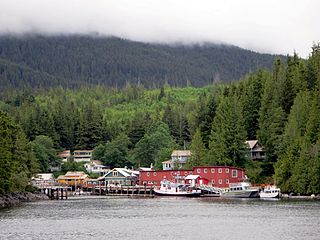
Washougal is a city in Clark County, Washington, United States. The population was 14,095 as of the 2010 Census.
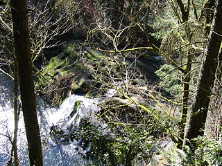
The Camas Potholes is a popular place to jump from moderately high cliffs into the waters below. On a hot, weekend day, the potholes attract people of all ages. The Camas Potholes can be accessed via a trail from Lacamas Park.

Lacamas Lake is a small lake in Clark County, Washington. It is a popular place to fish and water ski for locals from Vancouver, Camas and Washougal. It connects to Round Lake via a channel that runs under the SR 500 bridge on the southeast side of the lake. In the 1990s many high tech manufacturing plants and expensive housing developments began to appear in the area around the lake. The lake is very warm compared to other lakes in the area and the temperature can drop off quickly with depth. As it is now, the 60-foot-deep (18 m) lake cannot support life below about 18 ft (5.5 m). The Georgia-Pacific Mill in Camas used to draw water from the lake to support its operations; however, Georgia-Pacific donated the two dams on Round Lake to the City of Camas in 2018.

Watson Island is a neighborhood and man-made island in Biscayne Bay, in Miami, Florida, United States. Immediately east of the Central Business District and Arts & Entertainment District neighborhoods of Greater Downtown Miami, it is connected to the mainland and South Beach, Miami by the MacArthur Causeway.

The Portland metropolitan area is a metro area in the U.S. states of Oregon and Washington centered on the principal city of Portland, Oregon. The U.S. Office of Management and Budget (OMB) identifies it as the Portland–Vancouver–Hillsboro, OR–WA Metropolitan Statistical Area, a metropolitan statistical area used by the United States Census Bureau (USCB) and other entities. The OMB defines the area as comprising Clackamas, Columbia, Multnomah, Washington, and Yamhill Counties in Oregon, and Clark and Skamania Counties in Washington. The area's population is estimated at 2,753,168 in 2017.

The Washougal River is a 33-mile (53 km) tributary of the Columbia River in the U.S. state of Washington. Its headwaters and upper 21 miles (34 km) are in Skamania County in the Gifford Pinchot National Forest, and its lower 12 miles (19 km) are in Clark County. The river, which meets the Columbia near the cities of Washougal and Camas, is a popular stream for fishing, swimming, and boating.

Government Island is a 1,760-acre (710 ha) island in the Columbia River north of Portland, in Multnomah County, in the U.S. state of Oregon. Though Interstate 205 passes over it on the Glenn L. Jackson Memorial Bridge, access to the island is only by boat. There is a city controlled locked gate in the 205 fence.

Fisherman's Village is a waterfront mall, commercial boat anchorage and tourist attraction located in the world's largest man-made small boat harbor in Los Angeles County at Marina del Rey, California. The Ballona Wetlands State Ecological Reserve is immediately east of Fisherman's Village and immediately to the south is the federally-owned riverine estuary of Ballona Creek. The historical Fisherman's Village that was built 53 years ago in 1967 is nestled on the eastern bank of main harbor entrance channel between Whiskey Reds restaurant to the south and the Windward boatyard to the north.

Canyon Lake is a reservoir on the Guadalupe River in the Texas Hill Country in the United States. Canyon Lake is a U.S. Army Corps of Engineers reservoir formed on the Guadalupe River in Comal County by Canyon Dam, which is located about sixteen miles northwest of New Braunfels. The dam, lake, and all adjacent property are managed by the U.S. Army Corps Of Engineers. Water rights, waste water treatment, and hydroelectric generating facilities are managed by the Guadalupe-Blanco River Authority. Construction of the dam began in 1958 and was completed in 1964. The reservoir serves to provide flood control and water supply for the communities downstream from the dam. The lake is also a popular recreational destination.
Telegraph Cove is a community of about 20 inhabitants, on Vancouver Island in British Columbia, Canada, located approximately 210 kilometres (130 mi) northwest of Campbell River. It is a former fishing and cannery village that has become a launch point for eco-tourism. It shares the inlet with Beaver Cove which is 3 km (2 mi) up the inlet.
The World's Fair Marina is a public marina in Flushing Bay, Queens, New York. It is located at the northern edge of Flushing Meadows–Corona Park and operated by the Marine Division of the Department of Parks and Recreation. The marina is situated next to a 1.4-mile (2.3 km) long stretch of promenade around Flushing Bay and is also near LaGuardia Airport and Citi Field.

Grove Field is a public airport located three miles (5 km) north of the central business district of Camas, a city in Clark County, Washington, United States. It is located near Lacamas Lake which has a seaplane base. Due to the closing of Evergreen Field, many aircraft have moved to Grove Field.

Fort Vancouver Regional Libraries is a public library system in southwestern Washington state. The library district was established in 1950 as the first inter-county rural library district in Washington. The district has grown since 1950 to serve all of Clark, Skamania and Klickitat Counties, and the city of Woodland and the independent Yale Valley Library District in Cowlitz County.
Gee Creek is a 4th order tributary to the Columbia River, a.k.a. small creek, within Clark County, Washington named for William Gee, an early pioneer upon whose land the stream arose from. The Upper Gee Creek watershed, with an 8.7-square-mile (23 km2) drainage basin, is completely located within the Ridgefield quadrangle. The mainstem extends approximately 11.5 miles (18.5 km), of which 4.9 miles (7.9 km) are located within the Upper Gee Creek basin. Originating in the hills along Interstate 5, through Ridgefield, Washington and empties into a series of lakes on the Columbia River Floodplain. Abrams Park in Ridgefield is a local access point for Gee Creek and since 2003, has had a stream flow gauge installed to collect hydrological data. The lowest segment of Gee Creek meanders for 3 miles (4.8 km) through the Ridgefield National Wildlife Refuge.
Yale Park is a public waterfront park located on the shores of Yale Lake in Washington, United States. Besides a great view of Mount St. Helens, Yale Park provides 30 picnic sites, parking for 130 cars and 80 trailers, a boat ramp with four lanes and a swimming beach.
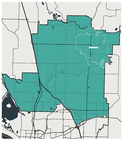
Washington State Legislative District 18 is one of forty-nine districts in Washington state for representation in the state legislature.

Garden Island is a locality in the Australian state of South Australia located in the Adelaide metropolitan area within the estuary of the Port Adelaide River about 15 kilometres north-west of the Adelaide city centre.
References
- 1 2 3 4 5 "Port of Camas - Washougal." Port of Camas - Washougal. N.p., n.d. Web. 23 June 2010. <http://portcw.com/index.php/about/ Archived 2013-12-30 at the Wayback Machine >
- 1 2 "Port of Camas-Washougal Boat Ramp and Marina." Lower Columbia River Estuary Partnership Water Trail. Lower Columbia River Estuary Partnership, n.d. Web. 23 June 2010. <http://www.columbiawatertrail.org/access/port_camas_washougal_boat_ramp_and_m%5B%5D
- ↑ "Port of Camas-Washougal Concludes Riverwalk Legal Process." Washington Ports Association. Washington Ports Association, 8 April 2010. Web. 23 June 2010. <http://www.washingtonports.org/washington_ports/040810camas.htm%5B%5D>
Coordinates: 45°34′43″N122°22′50″W / 45.57861°N 122.38048°W