Ards was a local government district in Northern Ireland with the status of borough. It was one of twenty-six districts formed on 1 October 1973, and had its headquarters in Newtownards. It was merged with neighbouring North Down on May 1, 2015 to form the new Borough of Ards and North Down. Other towns in the defunct Borough included Portaferry, Comber, and Donaghadee, and the population of the area was 78,078 according to the 2011 census.

Strangford is a parliamentary constituency in the United Kingdom House of Commons.

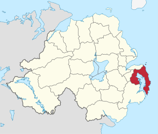
The Ards Peninsula is a peninsula in County Down, Northern Ireland, that separates Strangford Lough from the North Channel of the Irish Sea on the north-east coast of Ireland. Several towns and villages are located on it, including Donaghadee, Newtownards and Portaferry. Newtownards is considered to be the largest conurbation, as the larger town of Bangor, which is also geographically located on the north end of the peninsula, is excluded from the Ards district. The peninsula has a mild marine microclimate, with dry and fertile soils suitable for extensive agriculture. The Ards Peninsula contains, near Portavogie, the most easterly point on the island of Ireland.

The Quoile is a river in County Down, Northern Ireland.

Ardglass Marina, also known as Phennick Cove Marina, is situated in Ardglass, County Down, one of three major fishing ports in Northern Ireland. Ardglass is now one of the safest small harbours on the east coast of Ireland, following improvements made in recent years.

Clough is a village and townland in County Down, Northern Ireland. It sits about 3 miles from Dundrum on the A2 between Newcastle and Belfast. The A2 continues via Downpatrick and the coast via Strangford and the Portaferry - Strangford Ferry to Portaferry to Belfast, whilst most road traffic heads along from Clough along the A24 via Carryduff to Belfast. It had a population of 255 people in the 2001 Census. Clough is situated within the Newry, Mourne and Down area.

The A2 is a major road in Northern Ireland, a considerable length of which is often referred to the Antrim Coast Road because much of it follows the scenic coastline of County Antrim; other parts of the road follow the coasts in Counties Down and Londonderry.

Killinchy is a townland and small village in County Down, Northern Ireland. It is two miles inland from the western shores of Strangford Lough in the Borough of Ards and North Down. It is situated in the townland of the same name, the civil parish of Killinchy and the historic barony of Dufferin. It had a population of 539 people in the 2011 Census.

Strangford Castle is a castle on a height overlooking the harbour in Strangford, County Down, Northern Ireland, across Strangford Lough from Portaferry Castle. It was probably originally built in the 15th century but most of the present building dates from the late 16th century. Strangford Castle tower house is a State Care Historic Monument in the townland of Strangford Lower, in Down District Council area, at grid ref: J5887 4983.
The A20 is a road in Northern Ireland. It runs from Belfast to Newtownards and on to Portaferry in County Down.
Strangford is a constituency in the Northern Ireland Assembly.

Exploris is a public aquarium situated in Portaferry, Northern Ireland. The facility is located on the shores of the Marine Nature reserve of Strangford Lough, which is an important winter migration destination for many wading and sea birds. The lough is home to almost 75% of the marine species found in Northern Ireland, including common seals, basking sharks and brent geese. Three quarters of the world population of pale bellied brent geese spend winter in the lough area. Exploris illustrates and exhibits the large variety of animals that live in Strangford Lough.

SeaGen was the world's first large scale commercial tidal stream generator. It was four times more powerful than any other tidal stream generator in the world at the time of installation.

Przewóz is a village in Gmina Studzienice, Bytów County, Pomeranian Voivodeship, in northern Poland. It lies approximately 12 kilometres (7 mi) south of Bytów and 78 km (48 mi) south-west of Gdańsk.
The A25 is the name given to the sections of the main route connecting Strangford with Castleblayney that lie in Northern Ireland. It is a road of regional importance, serving much of south Armagh and south Down. The road commences in the village of Strangford, on the shores of Strangford Lough, from which the Portaferry - Strangford Ferry service transports vehicles to Portaferry on the Ards peninsula. The entirety of the route is 61.2 miles, of which 54.5 miles are located north of the border, forming the A25 - the remaining 6.7 miles form the R182 in the Republic of Ireland.

MV Portaferry II is a passenger and car ferry operated by Transport NI. This ferry serves the Portaferry–Strangford ferry route across the mouth of Strangford Lough in Northern Ireland, a service which has been in operation since the 12th century.

The Portaferry–Strangford ferry service crosses Strangford Lough at its narrowest point, close to where the lough joins the Irish Sea. The ferry links the two disconnected sections of the A2 road, Muff to Portaferry and Strangford to Newry. There has been a ferry service between Portaferry and Strangford for four centuries without a break. The alternative road journey is 47 miles (76 km), while the ferry crosses the 0.6 nautical miles in 8 minutes.


