
Les Sablons is a station on Line 1 of the Paris Métro in the commune of Neuilly-sur-Seine west of the city. In 2019 Les Sablons ranked 53rd in passenger volume among the system's 302 stations. The station is located under Avenue Charles de Gaulle, a major traffic artery between Etoile and La Defense. It has four entrances, a pair located on each of the medians on opposite sides of the Avenue.

Reuilly–Diderot is a station on lines 1 and 8 of the Paris Métro in the 12th arrondissement.

Porte Maillot is a station on Paris Métro Line 1. It is connected to the station Neuilly–Porte Maillot on the RER C and RER E, as well as a stop of tramway line T3b. The station in its current form opened in 1937, replacing the original Porte Maillot station that opened in 1900 as the original terminus of Line 1. It serves the Palais des Congrès and has exits towards Neuilly-sur-Seine. It is located close to the Bois de Boulogne.

Nation station is a station of the Paris Métro and Île-de-France's RER commuter rail service. It serves Line 1, Line 2, Line 6 and Line 9 of the Paris Métro and RER A. It takes its name from its location at the Place de la Nation.
RER E is one of the five lines in the Réseau Express Régional, a hybrid commuter rail and rapid transit system serving Paris and its suburbs. The 60-kilometre (37 mi) line travels between western and eastern suburbs, with all trains serving the stations in central Paris, before branching out towards the ends of the line.

Paris Métro Line 1 is one of the sixteen lines of the Paris Métro. It connects La Défense in the northwest and Château de Vincennes in the southeast. With a length of 16.5 km (10.3 mi), it constitutes an important east–west transportation route within the City of Paris. Excluding Réseau Express Régional (RER) commuter lines, it is the busiest line on the network with 181.2 million travellers in 2017 or 496,000 people per day on average.

Paris Métro Line 2 is one of the sixteen lines of the Paris Métro. Situated almost entirely above the former customs barrier around the capital, it runs in a semicircle in the north of Paris.

The N13 is a trunk road in France between Paris and Cherbourg.

Île-de-France tramway lines 3a and 3b are the first modern tramway in Paris proper since the 1937 closure of the previous comparable system. They are operated by the RATP and divided into two sections called T3a and T3b. The line is also known as the Tramway des Maréchaux because it follows the Boulevards of the Marshals, a series of boulevards that encircle Paris along the route of the former Thiers Wall. The boulevards are, with three exceptions, named for Napoleon's First Empire marshals (maréchaux); they were transformed by redevelopment works carried out during the two and a half year construction of the line, which opened on 16 December 2006 under the designation T3.
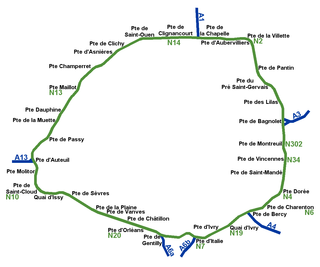
While Paris is encircled by the Boulevard Périphérique, the city gates of Paris are the access points to the city for pedestrians and other road users. As Paris has had successive ring roads through the centuries, city gates are found inside the modern-day Paris.

Porte de Clichy station is a station on Line 13 and Line 14 of the Paris Métro and RER C, as well as a stop on Île-de-France tramway Line 3b. Located in the 17th arrondissement, the Métro station is situated on the northwestern branch of Line 13, under the Avenue de Clichy. It serves the Tribunal de grande instance de Paris. The station is named after the Porte de Clichy, a gate in the nineteenth century Thiers wall of Paris, which led to Clichy.

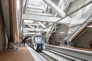
Neuilly–Porte Maillot station is a station in Paris's express suburban rail system, the RER. It is situated in the 17th arrondissement of Paris. It is served by RER C since 1988, and is served by RER E since its extension to the west on 6 May 2024. It is connected to Porte Maillot station on Paris Métro Line 1, as well as a tram stop on tramway Line T3b. The station is close to the Palais des congrès de Paris, as indicated by the station's subtitle.

The Palais des congrès de Paris is a convention centre, concert venue, and shopping mall at the Porte Maillot in the 17th arrondissement of Paris, France. The venue was built by French architect Guillaume Gillet, and was inaugurated in 1974. Nearby the venue are Bois de Boulogne and the affluent neighbourhood of Neuilly-sur-Seine. The closest métro and RER stations are Porte Maillot and Neuilly–Porte Maillot, accessible via the lower levels of the building.
Ghost stations of the Paris Métro are stations that have been closed to the public and are no longer used in commercial service. For historical or economical reasons, many stations on the Paris Métro have been made inaccessible and lie unused, conferring a sense of mystery over Parisians.

The Porte de Vincennes is one of the city gates of Paris (France) situated in the Bel Air neighborhood of the 12th arrondissement.

Cernay is a railway station in the commune of Ermont, France. The station is served by trains of the Paris Nord line H and the RER C. It takes around 25 minutes to reach Paris Gare du Nord or Neuilly Porte Maillot stations from Gare de Cernay.

The Avenue de la Grande Armée is an avenue in Paris, France, marking the boundary between its 16th and 17th arrondissements. It was formerly named Avenue de la Porte Maillot as part of Route nationale 13, but was renamed to its present name in 1864 in honour of the Grande Armée of the Napoleonic Wars.

The Avenue Charles-de-Gaulle is an avenue in Neuilly-sur-Seine, Paris, France, named after Charles de Gaulle.
The following outline is provided as an overview of and topical guide to Paris:

