
The Stirling council area is one of the 32 council areas of Scotland, and has a population of about 94,330. It was created under the Local Government etc (Scotland) Act 1994 with the boundaries of the Stirling district of the former Central local government region, and it covers most of Stirlingshire and the south-western portion of Perthshire. Both counties were abolished for local government purposes under the Local Government (Scotland) Act 1973.

Rannoch is an area of the Scottish Highlands between the A9 road, to the east, and the A82, to the west. The area is crossed from south to north by the West Highland railway line.
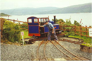
The Isle of Mull Railway was a 10 1⁄4 in gauge line, 1 1⁄4 miles (2.0 km) long, which ran from the ferry terminal at Craignure to Torosay Castle, on the Isle of Mull in the Scottish Inner Hebrides. Originally it was known as the Mull and West Highland Railway. The line was marketed as Scotland's original island passenger railway. The line opened in 1983 and closed in October 2010. A limited service operated over the 2011 Easter holiday and during summer 2011. The company's lease expired in October 2011. The track was lifted in October 2012.

The Pass of Drumochter meaning simply 'high ridge' is the main mountain pass between the northern and southern central Scottish Highlands. The A9 road passes through here, as does the Highland Main Line, the railway between Inverness and the south of Scotland. The Sustrans National Cycle Route 7 between Glasgow and Inverness also runs through the pass.

Leum Uilleim is a mountain in Lochaber, Highland, Scotland which appeared in the film Trainspotting. It is situated about 3 km south-west of the remote Corrour railway station, but is considerably further from any road.

The West Highland Railway was a railway company that constructed a railway line from Craigendoran to Fort William and Mallaig. The line was built through remote and difficult terrain in two stages: the section from Craigendoran to Fort William opened in 1894, with a short extension to Banavie on the Caledonian Canal opening in 1895.

Claggan Park is a football ground in Fort William in the West Highlands of Scotland, which is the home ground of Highland Football League side Fort William. It is located on Achintee Road on the outskirts of the town and has a capacity of 1,800 with 400 seated. The ground is often considered the most picturesque in Great Britain due to its proximity to the foothills of Ben Nevis, the highest point in the United Kingdom.
Abercrombie is a village in Fife, Scotland.

Stob Coire Easain is a Scottish Munro mountain which reaches a height of 1115 metres (3658 feet), situated 18 kilometres east of Fort William. It stands on the western side of Loch Treig, along with its "twin", the Munro Stob a' Choire Mheadhoin. Collectively the pair are called "The Easains" or the "Stob Corries" and stand just one kilometre apart connected by a high col with an approximate height of 965 metres. The fine corrie of Coire Easain Beag lies in between the two mountains facing north west. Stob Coire Easain’s name translates from the Gaelic as “Peak of the Corrie of the Little Waterfall”. This mountain should not be confused with another Stob Coire Easain, a Munro “Top” on the Munro Stob Coire an Laoigh
Fort William Junction is a railway junction on the West Highland Line in Scotland, located to the east of Fort William railway station. It is where the railway to Mallaig connects with the Glasgow to Fort William railway.

Stob a' Choire Mheadhoin is a mountain in the Scottish Highlands, it is situated 19 km east of Fort William in the Lochaber area of the Highland council area.

Alcomdale is a hamlet in central Alberta, Canada within Sturgeon County. It is located on Highway 44, approximately 34 kilometres (21 mi) northwest of Edmonton's city limits. There is a community hall and public playground within the hamlet, no other services.

The East Highland Way is a long distance walking route in Scotland that connects Fort William (56.8178°N 5.1109°W) with the ski and mountain resort of Aviemore (57.1899°N 3.8292°W). The route was described by Kevin Langan in 2007. The name is derived from the fact that the route terminates in Aviemore at the eastern edge of Highland region. The EHW route takes in a varied and wild landscape through deep forest plantations, passing many highland lochs and negotiating unspoilt marshlands. The route also explores the ancient Caledonian forests of Inshriach. The walk is 82 miles (132 km) long.
Glen Falloch Halt railway station or Glenfalloch Platform railway station was a remote rural railway station in Glen Falloch, Stirlingshire, Scotland. Opened in 1946 by the LNER, it was located in Glen Falloch on the Ardlui side of the viaduct, but reported out of use by around 1948.

Glen Douglas Halt railway station was known as Craggan in the line's construction reports, also Glen Douglas Siding, Glen Douglas Platform (Private), Glen Douglas (Private) and finally Glen Douglas Halt. Opened by the North British Railway in 1894 or 1895 its status has changed several times along with its official name. The form Glendouglas was also sometimes used, such as on the platform name board.
Inveruglas was a remote temporary private railway station near the hamlet of Inveruglas, Argyll and Bute, Scotland. Opened in 1945 by the LNER, it was built in connection with the construction of the Sloy Hydro-Electric facility and was located on the Ardlui side of the Inveruglas Viaduct and recorded to be out of use by around 1948.

Whistlefield, later Whistlefield Halt, was a minor station on the West Highland Line 10.30 miles from Craigendoran Junction railway station near the hamlet of Portincaple on Loch Long, Argyll and Bute, Scotland. Opened in 1896 by the West Highland Railway, it was built on a single track section without a passing loop in between Garelochhead and Glen Douglas and closed by the British Railways Board in 1964.
Faslane Platform railway station or Faslane Junction Platform railway station was a temporary private railway station located near the Stuckendoff PoW camp, Shandon, Argyll and Bute, Scotland. Opened in 1945 by the LNER in connection with the construction of the Loch Sloy Hydro-Electric facility and was located on the Shandon side of the Chapel Burn and recorded to be out of use by around 1949 in the British Railways era.

Whistlefield is a location just north of Garelochhead on the B872 in Dunbartonshire, Scotland. There is a roundabout known locally as the "Whistlefield roundabout" on the A814 road. There is a viewpoint called the "Whistlefield viewpoint" with a picnic area and an associated carpark.

