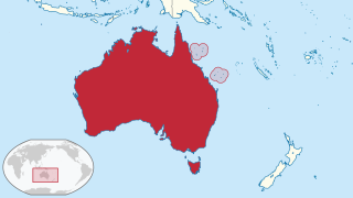
The Coral Sea Islands Territory is an external territory of Australia which comprises a group of small and mostly uninhabited tropical islands and reefs in the Coral Sea, northeast of Queensland, Australia. The only inhabited island is Willis Island. The territory covers 780,000 km2 (301,160 sq mi), most of which is ocean, extending east and south from the outer edge of the Great Barrier Reef and includes Heralds Beacon Island, Osprey Reef, the Willis Group and fifteen other reef/island groups. Cato Island is the highest point in the Territory.
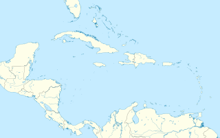
Jamaica is an island country situated in the Caribbean Sea. Spanning 10,990 square kilometres (4,240 sq mi) in area, it is the third-largest island of the Greater Antilles and the Caribbean. Jamaica lies about 145 kilometres (90 mi) south of Cuba, and 191 kilometres (119 mi) west of Hispaniola ; the British Overseas Territory of the Cayman Islands lies some 215 kilometres (134 mi) to the north-west.
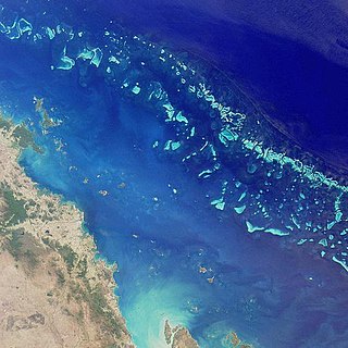
The Great Barrier Reef is the world's largest coral reef system composed of over 2,900 individual reefs and 900 islands stretching for over 2,300 kilometres (1,400 mi) over an area of approximately 344,400 square kilometres (133,000 sq mi). The reef is located in the Coral Sea, off the coast of Queensland, Australia. The Great Barrier Reef can be seen from outer space and is the world's biggest single structure made by living organisms. This reef structure is composed of and built by billions of tiny organisms, known as coral polyps. It supports a wide diversity of life and was selected as a World Heritage Site in 1981. CNN labelled it one of the seven natural wonders of the world. The Queensland National Trust named it a state icon of Queensland.
The Great Barrier Reef Marine Park protects a large part of Australia's Great Barrier Reef from damaging activities. It is a vast multiple-use Marine Park which supports a wide range of uses, including commercial marine tourism, fishing, ports and shipping, recreation, scientific research and Indigenous traditional use. Fishing and the removal of artefacts or wildlife is strictly regulated, and commercial shipping traffic must stick to certain specific defined shipping routes that avoid the most sensitive areas of the park. The Great Barrier Reef is the largest and best known coral reef ecosystem in the world. Its reefs, almost 3000 in total, represent about 10 per cent of all the coral reef areas in the world. It supports an amazing variety of biodiversity, providing a home to thousands of coral and other invertebrate species, bony fish, sharks, rays, marine mammals, marine turtles, sea snakes, as well as algae and other marine plants.

Little Cayman is one of three Islands comprising the Cayman Islands. It is located in the Caribbean Sea, approximately 60 miles northeast of Grand Cayman and five miles (8 km) west of Cayman Brac. Little Cayman is by far the least populous, with a permanent population of about 250. The majority of the population are ex-pat workers from Jamaica, Philippines & Honduras and from other Latin American countries as well as Canada, USA, India, South Africa, and England. There are a handful of local Caymanians estimated as less than 20. It is about 10 miles (16 km) long with an average width of 1 mile (2 km) and most of the island is undeveloped. Almost the entire island is at sea level. The highest elevation is about 40 feet.

Anegada is the northernmost of the British Virgin Islands (BVI), a group of islands that form part of the archipelago of the Virgin Islands. It lies approximately 15 miles (24 km) north of Virgin Gorda. Anegada is the only inhabited British Virgin Island formed from coral and limestone, rather than being of volcanic origin. While the other islands are mountainous, Anegada is flat and low. Its highest point is only about 28 feet (8.5 m) above sea level, earning it its name, which is the Spanish term for the flooded land, "tierra anegada".

A marine reserve is a type of marine protected area that has legal protection against fishing or development. As of 2007 less than 1% of the world's oceans had been set aside in marine reserves. Benefits include increases in the diversity, density, biomass, body size and reproductive potential of fishery and other species within their boundaries.

St Catherine is a parish in the south east of Jamaica. It is located in the county of Middlesex, and is one of the island's largest and most economically valued parishes because of its many resources. It includes the first capital of Jamaica, Spanish Town, originally known as San Jago de la Vega or Santiago de la Vega.

The Tubbataha Natural Park also known as Tubbataha Reefs Natural Park is a protected area of the Philippines located in the middle of the Sulu Sea. The marine and bird sanctuary consists of two huge atolls and the smaller Jessie Beazley Reef covering a total area of 97,030 hectares. It is located 150 kilometres (93 mi) southeast of Puerto Princesa City, the capital of Palawan province. The uninhabited islands and reefs are part of the island municipality of Cagayancillo, Palawan, located roughly 130 kilometres (81 mi) to the northeast of the reef.
Pedro Bank is a large bank of sand and coral, partially covered with seagrass, about 80 km south and southwest of Jamaica, rising steeply from a seabed of 800 metres depth. It slopes gently from Pedro Cays to the west and north with depths from 13 to 30 metres. The total area of the bank within the 100-metre (328-foot) isobath measures 8,040 square kilometres. The area of a depth to 40 metres is triangular, 70 kilometres long east-west, and 43 kilometres wide. 2,400 square kilometres are less than 20 metres deep. With its islets, cays and rocks, a total land area of 270,000 m2 (2,906,256 sq ft), it is the location of one of the two offshore island groups of Jamaica, the other one being the Morant Cays. The bank is centered at 17°06′N78°20′W.

The Papahānaumokuākea Marine National Monument is a World Heritage listed U.S. National Monument encompassing 583,000 square miles (1,510,000 km2) of ocean waters, including ten islands and atolls of the Northwestern Hawaiian Islands. Created in June 2006 with 140,000 square miles (360,000 km2), it was expanded in August 2016 by moving its border to the limit of the exclusive economic zone, making it one of the world's largest protected areas. It is internationally known for its cultural and natural values as follows:
"The area has deep cosmological and traditional significance for living Native Hawaiian culture, as an ancestral environment, as an embodiment of the Hawaiian concept of kinship between people and the natural world, and as the place where it is believed that life originates and to where the spirits return after death. On two of the islands, Nihoa and Mokumanamana, there are archaeological remains relating to pre-European settlement and use. Much of the monument is made up of pelagic and deepwater habitats, with notable features such as seamounts and submerged banks, extensive coral reefs and lagoons."

The Pacific Remote Islands Marine National Monument is a group of unorganized, mostly unincorporated United States Pacific Island territories managed by the Fish and Wildlife Service of the United States Department of the Interior and the National Oceanic and Atmospheric Administration (NOAA) of the United States Department of Commerce. These remote refuges are "the most widespread collection of marine- and terrestrial-life protected areas on the planet under a single country's jurisdiction". They protect many endemic species including corals, fish, shellfish, marine mammals, seabirds, water birds, land birds, insects, and vegetation not found elsewhere.
Greenpeace Australia Pacific (GPAP) is the regional office of the global environmental organisation Greenpeace. Greenpeace Australia Pacific is one of Australia's largest environmental organisations.

Claverty Cottage is a small settlement located about 5 miles/8 km from Blue Mountain Peak in the parish of Portland, Jamaica. The population of this settlement is approximately 600 inhabitants. The district is known for its production of one of the most popular coffee brands in the island. Over the last several decades, this coffee has developed a reputation that has made it one of the most expensive and highly sought coffees in the world. In addition to its use for brewed coffee, the beans are the flavor base of Tia Maria coffee liqueur.

The Nuyts Archipelago is an island group located in South Australia in the Great Australian Bight to the south of the town of Ceduna on the west coast of the Eyre Peninsula. It consisting of mostly granitic islands and reefs that provide breeding sites for Australian sea lions and support colonies of short-tailed shearwater. It also includes the island group known as the Isles of St Francis. All the islands with exception of a part of Evans Island, are located with the following protected areas - the Nuyts Archipelago Wilderness Protection Area and the Nuyts Archipelago Conservation Park.

Great Goat Island is a cay located less than a mile off the coast of Jamaica, southwest of the Hellshire Hills. It is part of Saint Catherine Parish. Along with Little Goat Island located northwest of it, these two cays make up the Goat Islands, which are within the Portland Bight Protected Area.
Little Goat Island along with Great Goat Island are the cays that make up the Goat Islands, located less than a mile off the coast of Jamaica, southwest of the Hellshire Hills. It is part of Saint Catherine Parish. Little Goat Island is adjacent to the northwest portion of Great Goat Island, and both are within the Portland Bight Protected Area.
Australian marine parks are marine protected areas located within Australian waters and are managed by the Australian government. These waters generally extend from three nautical miles off the coast to the outer limit of Australia’s Exclusive Economic Zone at 200 nautical miles while marine protected areas located closer in-shore are the responsibility of the states or the Northern Territory.
Hellshire Hills is a region of dry limestone hills in St Catherine Parish, Jamaica, which forms part of the Portland Bight Protected Area. The region supports one of the largest remaining areas of dry limestone forest in the Caribbean, and supports endangered Jamaican endemics include the Jamaican iguana and the blue-tailed galliwasp.

Jamaica, an island located within the Caribbean Sea, known for being a popular tourist destination because of its pristine white sand beaches, is now faced with the issue of mass coral depletion. Both environmental and human factors contribute to the destruction of these corals, which inevitably affect Jamaica's environmental sustainability and economy. Actions have been put in place to counteract the negative consequences associated with the loss of the corals, which act as a symbol of hope for the revival of Jamaica's environment.
