
Portnadler Bay lies 1.5 miles to the south-west of the town of Looe, Cornwall. It contains a secluded beach [1] that is reachable on foot via a steep path that descends from the main coastal path.
Portnadler Bay lies 1.5 miles to the south-west of the town of Looe, Cornwall. It contains a secluded beach [1] that is reachable on foot via a steep path that descends from the main coastal path.

North Cornwall is an area of Cornwall, England, United Kingdom. It is also the name of a former local government district, which was administered from Bodmin and Wadebridge 50.516°N 4.835°W. Other towns in the area are Launceston, Bude, Padstow, and Camelford.

The Saints' Way is an ancient trackway and long-distance footpath in mid Cornwall, England, UK.

Mystery Lake is a local government district (LGD) in northern Manitoba. It surrounds the city of Thompson, although most of its territory lies to the southwest and south of the city. It is named after Mystery Lake, a lake located in the northeast section of the LGD, northeast of Thompson.
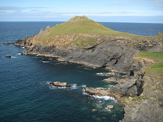
The Rumps is a twin-headland promontory at the north-east corner of Pentire Head in north Cornwall, United Kingdom.

Kelynack is a settlement in west Cornwall, England, UK.

St Anthony-in-Meneage is a coastal civil parish and village in Cornwall, England, United Kingdom. The parish is in the Meneage district of the Lizard peninsula. In the 2001 census the parish had a population of 171, decreasing to 168 at the 2011 census.

St Just in Roseland is a village and civil parish in Cornwall, England, United Kingdom. The village is 6 miles (10 km) south of Truro and 2 miles (3 km) north of St Mawes, a small village within the parish of St Just in Roseland. The 2011 Census recorded the parish population as 1,158.

Welcombe is a village and civil parish on the coast of north Devon, England, just north of the border with Cornwall. It is part of the district of Torridge. The population taken at the 2011 census was 187.
There are seventeen disused railway stations on the Cornish Main Line between Plymouth in Devon and Penzance in Cornwall, England. The remains of nine of these can be seen from passing trains. While a number of these were closed following the so-called "Beeching Axe" in the 1960s, many of them had been closed much earlier, the traffic for which they had been built failing to materialise.

Seaton Valley Countryside Park is the newest of Cornwall's four Country Parks. It is situated in the Seaton valley between the villages of Seaton and Hessenford. It includes two Local Nature Reserves, Seaton Valley North and Seaton Valley South.
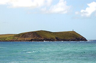
Stepper Point is a headland on the Atlantic coast in north Cornwall, England, United Kingdom. It is at grid reference SW911781.
Pont Pill, joins the River Fowey at Penleath Point just below the memorial to Sir Arthur Quiller-Couch at the north-east corner of Fowey harbour. Pont Pill is a tidal river and is only navigable at high water.

Ampress Works Halt was a halt station on the Lymington Branch Line which, between 1956 and 1989, served the Wellworthy engineering works near Lymington in Hampshire, England. Sited near the bridge over the A337 Lymington to Brockenhurst road, the station closed when the engineering works ceased operation. The station never appeared in any public timetable.
Trevose Head is a headland on the Atlantic coast of north Cornwall, United Kingdom. It is situated approximately 5 miles (8.0 km) west of Padstow. The South West Coast Path runs around the whole promontory and is within the Cornwall Area of Outstanding Natural Beauty and the Trevose Head Heritage Coast. In clear weather, visitors to Trevose Head can see virtually the whole length of the north Cornwall coast; to the north, the view extends beyond the Cornwall county boundary to Hartland Point, Devon; to the south, it extends beyond St Ives to the headland at Pendeen Watch.

Lanteglos-by-Fowey is a coastal civil parish in south Cornwall, England, United Kingdom. It is on the east side of the tidal estuary of the River Fowey which separates it from the town and civil parish of Fowey. The South West Coast Path runs along the southern coasts of the parish and much of the southern part of the parish lies in the Polruan to Polperro Site of Special Scientific Interest managed by the National Trust.

Gribbin Head is a promontory on the south coast of Cornwall, England, UK, owned and managed by the National Trust. It separates St Austell Bay from the estuary of the River Fowey and is marked by a large tower used to aid navigation of ships approaching the local harbours. The nearest town is Fowey. The western point of the headland is called Little Gribbin.

The River Ottery is a small river in northeast Cornwall, United Kingdom. The river is about twenty miles (32 km) long from its source southeast of Otterham to its confluence with the River Tamar at Nether Bridge, two miles (3.2 km) northeast of Launceston.

The St Austell River properly known as the River Vinnick, but historically called The White River, is a 12 kilometres (7.5 mi) long river located in south Cornwall, England, United Kingdom. 50.337°N 4.793°W. The river has also been known as the "red river" due to tin streaming and mining activity upstream.

Gerrans Bay to Camels Cove is a coastal Site of Special Scientific Interest (SSSI) in south Cornwall, England, UK, noted for both its biological and geological interest.

Meneage Coastal Section is a coastal Site of Special Scientific Interest (SSSI) in southern Cornwall, England, UK, noted for its geological characteristics.
Coordinates: 50°20′13″N4°27′50″W / 50.337°N 4.464°W
| This Cornwall location article is a stub. You can help Wikipedia by expanding it. |