Related Research Articles

An alley or alleyway is a narrow lane, path, or passageway, often reserved for pedestrians, which usually runs between, behind, or within buildings in the older parts of towns and cities. It is also a rear access or service road, or a path, walk, or avenue in a park or garden.

North Melbourne is an inner-city suburb in Melbourne, Victoria, Australia, 3 km (1.9 mi) north-west of Melbourne's Central Business District, located within the City of Melbourne local government area. North Melbourne recorded a population of 14,953 at the 2021 census.

Dandenong is a southeastern suburb of Melbourne, Victoria, Australia, about 35 km (22 mi) from the Melbourne CBD. It is the council seat of the City of Greater Dandenong local government area, with a recorded population of 30,127 at the 2021 census. Situated mainly on the northwest bank of the lower Dandenong Creek, it is 21.6 km (13.4 mi) from the eponymous Dandenong Ranges to its northeast and completely unrelated in both location and nature of the settlement.
Urban planning in Singapore is the direction of infrastructure development in Singapore. It is done through a three-tiered planning framework, consisting of a long-term plan to plot out Singapore's development over at least 50 years, a Master Plan for the medium term, and short-term plans, the first two of which are prepared by the Urban Redevelopment Authority (URA) and the last by multiple agencies.
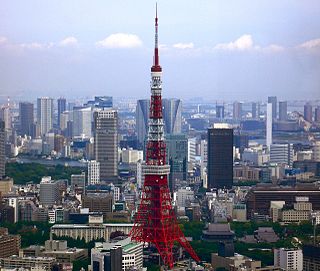
The Japanese asset price bubble was an economic bubble in Japan from 1986 to 1991 in which real estate and stock market prices were greatly inflated. In early 1992, this price bubble burst and Japan's economy stagnated. The bubble was characterized by rapid acceleration of asset prices and overheated economic activity, as well as an uncontrolled money supply and credit expansion. More specifically, over-confidence and speculation regarding asset and stock prices were closely associated with excessive monetary easing policy at the time. Through the creation of economic policies that cultivated the marketability of assets, eased the access to credit, and encouraged speculation, the Japanese government started a prolonged and exacerbated Japanese asset price bubble.

Melbourne 2030 is a Government of Victoria strategic planning policy framework for the metropolitan area of Melbourne, Australia intended to cover the period 2001–2030. During this period the population of the metropolitan area is expected to grow by a million people to over five million. Population projections now predict Melbourne's population could reach seven million by that time and the government has since changed its strategy on the policy, abandoning the urban growth boundary in the north and west of Melbourne and reducing green wedges.

The Melbourne central business district is the city centre and main urban area of the city of Melbourne, Victoria, Australia, centred on the Hoddle Grid, the oldest part of the city laid out in 1837, and includes its fringes. The Melbourne CBD is located in the local government area of the City of Melbourne which also includes some of inner suburbs adjoining the CBD.

Secondary suites are self-contained apartments, cottages, or small residential units, that are located on a property that has a separate main, single-family home, duplex, or other residential unit. In some cases, the ADU or in-law is attached to the principal dwelling or is an entirely separate unit, located above a garage or in the backyard on the same property. In British English the term annex or granny annex is used instead. Reasons for wanting to add a secondary suite to a property may be to receive additional income, provide social and personal support to a family member, or obtain greater security.

Seven neighbourhoods are of considerable note:
Activity centre is a term used in urban planning and design for a mixed-use urban area where there is a concentration of commercial and other land uses. For example, the central business districts of cities (CBD) are also known as “Central Activities Districts” (CAD) (also known as Downtown in North America or "Central Activities Zone" in the United Kingdom in recognition of the fact that commercial functions are not the only things that occur there. The term activity centre can also be used to designate an area for mixed-use development, whatever its current land use happens to be.
Urban consolidation describes the policy of constraining further development and population growth to within the boundaries of preexisting urban areas rather than expanding outward into suburban areas. Urban consolidation seeks to increase the population density of a given urban area by expanding upward, redeveloping preexisting buildings and lots, and constructing new facilities in available spaces. It is theorized that discouraging urban sprawl and encouraging further development of housing units in preexisting urban areas will lead to a net gain in social and economic prosperity.

Melbourne is the capital of the Australian state of Victoria, and the second-most populous city in Australia, after Sydney,. Its name generally refers to a 9,993 km2 (3,858 sq mi) metropolitan area known as Greater Melbourne, comprising an urban agglomeration of 31 local municipalities, although the name is also used specifically for the local municipality of City of Melbourne based around its central business area. The metropolis occupies much of the northern and eastern coastlines of Port Phillip Bay and spreads into the Mornington Peninsula, part of West Gippsland, as well as the hinterlands towards the Yarra Valley, the Dandenong and Macedon Ranges. It has a population over 5 million, mostly residing to the east side of the city centre, and its inhabitants are commonly referred to as "Melburnians".

Melbourne is Australia's second largest city and has a diverse and multicultural population.

The Australian property market comprises the trade of land and its permanent fixtures located within Australia. The average Australian property price grew 0.5% per year from 1890 to 1990 after inflation, however rose from 1990 to 2017 at a faster rate and may be showing signs of a contracting economic bubble. House prices in Australia receive considerable attention from the media and the Reserve Bank and some commentators have argued that there is an Australian property bubble.
Robert John Adams is an architect and urban designer, currently working part-time as City Architect and previously as the Director of City Design at the City of Melbourne, Australia. He won multiple awards as the leader of the revitalisation of the Melbourne central business district and surrounds, helping to create a vibrant city streetscape with innovative design features.

A laneway house is a form of detached secondary suites in Canada built into pre-existing lots, usually in the backyard and opening onto the back lane. Most laneway houses are small. However, public concern has been raised in some communities about the impact that larger forms of this type of housing may have on privacy. Laneway houses are found in densely populated areas in Canadian cities, including Edmonton, Toronto, and Vancouver.
Urban planning in Australia has a significant role to play in ensuring the future sustainability of Australian cities. Australia is one of the most highly urbanised societies in the world. Continued population growth in Australian cities is placing increasing pressure on infrastructure, such as public transport and roadways, energy, air and water systems within the urban environment.
Mount Atkinson is a suburb in Melbourne, Victoria, Australia, 23 km (14 mi) northwest of the Melbourne central business district, located within the City of Melton local government area.

The urban renewal of Sydney is an ongoing land redevelopment process that is creating and reviving new urban centres across Sydney, Australia. Urban renewal refers to the refurbishment of derelict buildings, streets or neighbourhoods and is accompanied with the process of gentrification attributed by changes in land use and deindustrialisation of areas. In 2020, there are several projects underway and planned including Barangaroo, The Bays Precinct and Green Square.
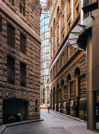
The lanes and alleyways of Sydney are a series of passageways found in Sydney central business district that have historically functioned by providing both off-street vehicular access to city buildings and secondary pedestrian routes through city blocks. They generally feature street art, cafes, restaurants, bars and retail outlets. The Rocks has the most prominent and historical laneways in Sydney, which date to the 19th century. Forgotten Songs is a popular attraction found in Angel Place.
References
- 1 2 3 4 "City of Melbourne - Strategic planning - Postcode 3000". City of Melbourne. Archived from the original on 2008-09-12. Retrieved 2020-12-01.
- 1 2 "Revitalising Melbourne's City Centre from 1985". Centre for Public Impact. 2019-09-02. Retrieved 2020-12-01.
- 1 2 3 "Postcode 3000; a city transformed". City of Melbourne. Archived from the original on 2018-02-27. Retrieved 2020-12-01.
- ↑ Oberklaid, Sarah (2015-09-16). "Melbourne: A Case Study in the Revitalization of City Laneways, Part 1". The Urbanist. Retrieved 2021-12-01.