

Pow Burn, a name used in Scotland for small watercourses, is a long burn located in South Ayrshire, Scotland. The name "Pow" or "Poll" refers to a slow-moving ditch-like stream. [1]
Pow Burn, a name used in Scotland for small watercourses, is a long burn located in South Ayrshire, Scotland. The name "Pow" or "Poll" refers to a slow-moving ditch-like stream. [1]
The Pow Burn is fed by a small loch near the estate of Coodham and is narrow until it reaches Prestwick, where it starts to widen. The Burn separates Prestwick and Monkton. [2] It crosses Prestwick Airport and flows through Prestwick Golf Course, where is serves as a natural obstacle. Prestwick Holiday Park overlooks the mouth of the burn, where it flows into the Firth of Clyde.
The Ayrshire Cycle Track, Route 7 and Ayrshire Coastal Path, Route7 cross over the burn by a bridge not far from the estuary.

At one time there were four mills operating on the Pow Burn. [2] Near the mouth was Prestwick Mill, later called Monkton Mill. Upstream were Powbank, situated near Monkton, Adamton Mill and, ¾ mile east of Symington, Helenton Mill. [2] The small tributary from Barnweil Loch had also the Heugh Mill.
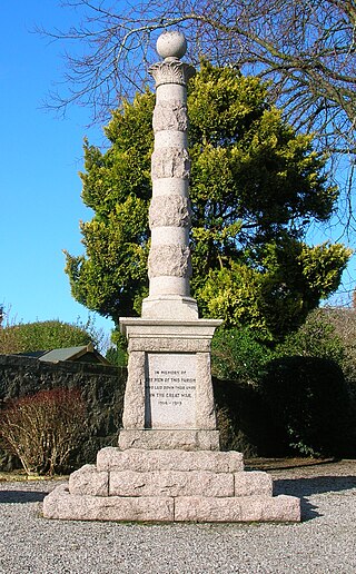
Powbank Mill closed at the outbreak of World War II, when it was requisitioned as a Canteen/Naafi. After the war, the mill never returned to the family, being the home of the Scottish Aviation Club, before they moved into the St Cuthbert's site on Kirk Street. [2]

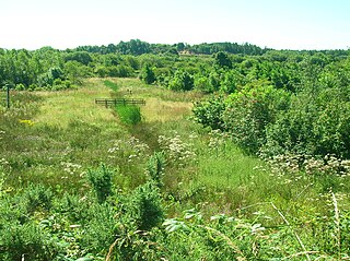
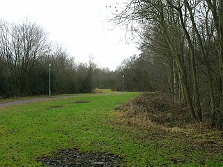
The Burn is one of the last coastal wildlife havens in South Ayrshire.[ citation needed ] Parts are designated as a Wildlife Corridor and as a Wildlife Site. [3] It has locally rare habitats and nationally rare species.
Plants and animals been sighted at the Pow include otters, red admiral, rare dragonfly species and songbirds such as thrush and nightingale. There has been a decline in the number of waxwings migrating to the area.
The Pow Burn is managed by the local council for conservation and recreation. It provides an area where families can picnic beside the burn and play on the sand dunes west of the burn. The dunes were once a sand quarry.[ citation needed ]

Ayrshire is a historic county and registration county, in south-west Scotland, located on the shores of the Firth of Clyde. The lieutenancy area of Ayrshire and Arran covers the entirety of the historic county as well as the island of Arran, formerly part of the historic county of Buteshire. Its principal towns include Ayr, Kilmarnock and Irvine and it borders the counties of Renfrewshire and Lanarkshire to the north-east, Dumfriesshire to the south-east, and Kirkcudbrightshire and Wigtownshire to the south. Like many other counties of Scotland, it currently has no administrative function, instead being sub-divided into the council areas of East Ayrshire, North Ayrshire and South Ayrshire. It has a population of approximately 366,800.

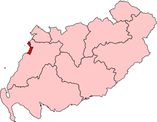
South Ayrshire is one of thirty-two council areas of Scotland, covering the southern part of Ayrshire. It borders onto Dumfries and Galloway, East Ayrshire and North Ayrshire. South Ayrshire had an estimated population in 2021 of 112,450, making it the 19th–largest subdivision in Scotland by population. With an area of 472 sq mi, South Ayrshire ranks as the 15th largest subdivision in Scotland.

Ayr is a town situated on the southwest coast of Scotland. A former royal burgh, today it is the administrative centre of the South Ayrshire Council, and the historic county town of Ayrshire. With a population of 46,982, Ayr is the 15th largest settlement in Scotland and second largest town in Ayrshire by population. The town is contiguous with the smaller town of Prestwick to the north. Ayr submitted unsuccessful bids for city status in 2000 and 2002, and as part of the wider South Ayrshire area in 2022.

Prestwick is a town in South Ayrshire on the west coast of Ayrshire in Scotland about 30 miles southwest of Glasgow. It adjoins the larger town of Ayr to the south on the Firth of Clyde coast, the centre of which is about two miles south, and the small village of Monkton to the north. It had a population of 14,901 at the 2011 census.

Kyle is a former comital district of Scotland which stretched across parts of modern-day East Ayrshire and South Ayrshire. It is supposedly named after Coel Hen, a legendary king of the Britons, who is said to be buried under a mound at Coylton.

Prestwick Golf Club is a golf course in Prestwick, South Ayrshire, Scotland. It is approximately 30 miles (50 km) southwest of Scotland's largest city, Glasgow. Prestwick is a classic links course, built on the rolling sandy land between the beach and the hinterland. The course is near the Prestwick airport, and some holes run along railway tracks on the eastern side of the course.

The Southern Uplands are the southernmost and least populous of mainland Scotland's three major geographic areas. The term is used both to describe the geographical region and to collectively denote the various ranges of hills and mountains within this region. An overwhelmingly rural and agricultural region, the Southern Uplands are partly forested and contain many areas of open moorland - the hill names in the area are congruent with these characteristics.
Ayr is a burgh constituency of the Scottish Parliament (Holyrood) covering the town of Ayr in the council area of South Ayrshire. It elects one Member of the Scottish Parliament (MSP) via the plurality electoral system. It is also one of nine constituencies in the South Scotland electoral region which elects seven additional members to the Scottish Parliament via a proportional electoral system known as the Additional Members System which allows for greater accuracy in representation for the region as a whole.

The River Garnock, the smallest of Ayrshire's six principal rivers, has its source on the southerly side of the Hill of Stake in the heart of the Clyde Muirshiel Regional Park. About a mile and a half south of this starting point the untested stream tumbles over the Spout of Garnock, the highest waterfall in Ayrshire, once thought to be the river's origin. The river then continues, for a total length of 20 miles (32 km) or so, through the towns of Kilbirnie, Glengarnock, Dalry and Kilwinning to its confluence with the River Irvine at Irvine Harbour.

Heathfield is a major district of Ayr, Scotland. Heathfield is on the borders of Ayr and Prestwick and is located beside the A77 Ayr by-pass. The Whitletts roundabout in Heathfield is the main roundabout connecting Ayr with other towns and cities. Heathfield has a lot of aviation history especially during World War II where there was an RAF base called RAF Heathfield.
Monkton is a small village in the parish of Monkton and Prestwick in South Ayrshire, Scotland. The town of Prestwick is around 1+1⁄2 miles south of the village, and it borders upon Glasgow Prestwick Airport.

Orangefield House, previously known as 'Monkton House', was located near the village of Monkton, Ayrshire in the Parish of Monkton and Prestwick in South Ayrshire, Scotland; the settlement borders upon Glasgow Prestwick Airport, for which it served for a while as the control tower.
Ardeer was a small town now officially incorporated into Stevenston on the Ardeer peninsula, in the parish of Stevenston, North Ayrshire, originally an island and later its extensive sand dune system became the site of Nobel Explosives, a dominant global supplier of explosives to the mining and quarrying industries and a major player in the design and development of products for the chemical and defence industries during the 20th century. The peninsula is now part of North Ayrshire's most important area for Biodiversity.
Littlestane Loch, was situated in the mid-Ayrshire clayland near Stanecastle, Irvine, North Ayrshire, Scotland. It is nowadays (2011) only visible as an area of permanent water in the Scottish Wildlife Trust Sourlie Nature Reserve. The loch was natural, sitting in a hollow created by glaciation. The loch waters outflow was via the Red Burn that flows into the River Garnock. The site of Littlestane Loch site is partly built over and much of the site is now public open space lying within the Parish of Girdle Toll.
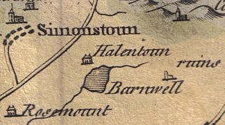
Helenton Loch was situated in a low lying area between the farms and dwellings of Helentongate, Mains, and Burnbank in the Parish of Symington, South Ayrshire, Scotland. The loch was natural, sitting in a hollow, a kettle hole, created by glaciation. The loch waters ultimately drained via the Pow Burn. Helenton Hill is a prominent landmark to the west of the old loch site. The nearby lands of Rosemount were in 1549 known as 'Goldring' and were the property of the Schaws of Sornbeg.

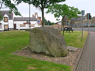
The Shaw Monument is an 18th-century structure that has been interpreted as a folly and stands about 1 mile East of Prestwick, overlooking Prestwick Airport in South Ayrshire, Scotland.
Symington is a conservation village in South Ayrshire, Scotland. It is located in Symington parish, covering 0.41 square kilometres, and lies close to the A77 road from Ayr to Glasgow. Its church, built in 1160, remains one of the finest examples of a Norman church in Scotland.

Lowes Loch, The Lochs or Loch of Hill is now a small natural freshwater loch in the North Ayrshire Council Areas, Scotland, lying in a glacial kettle hole, once of greater extent, lying below Brownmuir and Lochland Hills on the Threepwood Road, near Beith, in the Parish of Beith. The loch may once have had a small island within it.

Newton Loch was situated in a low-lying area near Newton-on-Ayr, South Ayrshire, just south of the old South and West Sanquhar Farms. It is now (2016) only visible as remnant heath land and surface darkening in pastureland, situated mainly in the Parish of Ayr and partly in St Quivox, South Ayrshire, Scotland.