Nanterre–Université station is an RER and SNCF train station in Nanterre, Hauts-de-Seine.
Jabkenice is a village in Central Bohemian Region, Czech Republic. It is located at around 50°19′27″N15°0′49″E. Composer Bedřich Smetana lived here from 1875 until his death.
Zbójenko is a village in the administrative district of Gmina Zbójno, within Golub-Dobrzyń County, Kuyavian-Pomeranian Voivodeship, in north-central Poland.
Bogołomia is a village in the administrative district of Gmina Chodecz, within Włocławek County, Kuyavian-Pomeranian Voivodeship, in north-central Poland.
Góra Blachowa is a village in the administrative district of Gmina Wojsławice, within Chełm County, Lublin Voivodeship, in eastern Poland.
Gościeradów-Kolonia is a village in the administrative district of Gmina Gościeradów, within Kraśnik County, Lublin Voivodeship, in eastern Poland.

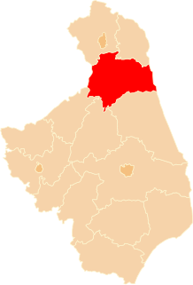
Muły is a village in the administrative district of Gmina Płaska, within Augustów County, Podlaskie Voivodeship, in north-eastern Poland, close to the border with Belarus. It lies approximately 16 kilometres (10 mi) east of Płaska, 35 km (22 mi) east of Augustów, and 90 km (56 mi) north of the regional capital Białystok.
Sarnów is a village in the administrative district of Gmina Widawa, within Łask County, Łódź Voivodeship, in central Poland. It lies approximately 10 kilometres (6 mi) south-east of Widawa, 26 km (16 mi) south of Łask, and 57 km (35 mi) south-west of the regional capital Łódź.
Podfranciszkany is a village in the administrative district of Gmina Nowy Kawęczyn, within Skierniewice County, Łódź Voivodeship, in central Poland. It lies approximately 4 kilometres (2 mi) north-west of Nowy Kawęczyn, 8 km (5 mi) south-east of Skierniewice, and 53 km (33 mi) east of the regional capital Łódź.
Białka-Kolonia is a village in the administrative district of Gmina Milejów, within Łęczna County, Lublin Voivodeship, in eastern Poland.
Weimer Township is a civil township in Barnes County, North Dakota, USA. As of the 2000 census, its population was 53.
Władysławów is a village in the administrative district of Gmina Garwolin, within Garwolin County, Masovian Voivodeship, in east-central Poland. It lies approximately 14 kilometres (9 mi) west of Garwolin and 47 km (29 mi) south-east of Warsaw.
Słomki is a village in the administrative district of Gmina Chodzież, within Chodzież County, Greater Poland Voivodeship, in west-central Poland. It lies approximately 9 kilometres (6 mi) east of Chodzież and 68 km (42 mi) north of the regional capital Poznań.
Wąsochy is a former settlement in the administrative district of Gmina Kępice, within Słupsk County, Pomeranian Voivodeship, in northern Poland. It lies approximately 10 kilometres (6 mi) south of Kępice, 36 km (22 mi) south of Słupsk, and 116 km (72 mi) west of the regional capital Gdańsk.
Płaczewo is a settlement in the administrative district of Gmina Starogard Gdański, within Starogard County, Pomeranian Voivodeship, in northern Poland. It lies approximately 8 kilometres (5 mi) south of Starogard Gdański and 53 km (33 mi) south of the regional capital Gdańsk.
Góry is a village in the administrative district of Gmina Białogard, within Białogard County, West Pomeranian Voivodeship, in north-western Poland. It lies approximately 12 kilometres (7 mi) south of Białogard and 111 km (69 mi) north-east of the regional capital Szczecin.
Osina is a village in Goleniów County, West Pomeranian Voivodeship, in north-western Poland. It is the seat of the gmina called Gmina Osina. It lies approximately 15 kilometres (9 mi) north-east of Goleniów and 36 km (22 mi) north-east of the regional capital Szczecin.

Yujiang District is a district of the city of Yingtan, Jiangxi province, China.
Vanaküla is a village in Lääne-Nigula Parish, Lääne County, in western Estonia.
Sidi M'Hamed Ou Marzouq is a small town and rural commune in Essaouira Province of the Marrakech-Tensift-Al Haouz region of Morocco. At the time of the 2004 census, the commune had a total population of 6088 people living in 882 households.