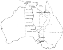
The Northern Territory is an Australian territory in the central and central northern regions of Australia. The Northern Territory shares its borders with Western Australia to the west, South Australia to the south, and Queensland to the east. To the north, the territory looks out to the Timor Sea, the Arafura Sea and the Gulf of Carpentaria, including Western New Guinea and other islands of the Indonesian archipelago.
The protected areas of the Northern Territory consists of protected areas managed by the governments of the Northern Territory and Australia and private organisations with a reported total area of 335,527 square kilometres (129,548 sq mi) being 24.8% of the total area of the Northern Territory of Australia.

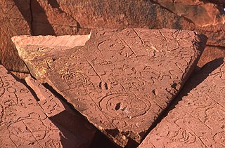
Karlu Karlu / Devils Marbles Conservation Reserve is a protected area in the Northern Territory of Australia located in the locality of Warumungu about 105 km (65 mi) south of Tennant Creek, and 393 km (244 mi) north of Alice Springs. The nearest settlement is the small town of Wauchope located 9 km (5.6 mi) to the south.
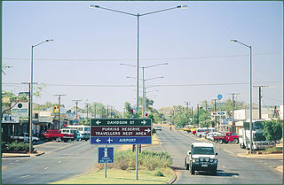
Tennant Creek is a town located in the Northern Territory of Australia. It is the seventh largest town in the Northern Territory, and is located on the Stuart Highway, just south of the intersection with the western terminus of the Barkly Highway. At the 2021 census, Tennant Creek had a population of 3,080 people, of which 55% (1,707) identified themselves as Indigenous.

Stuart Highway is a major Australian highway. It runs from Darwin, in the Northern Territory, via Tennant Creek and Alice Springs, to Port Augusta in South Australia; it has a distance of 2,720 km (1,690 mi). Its northern and southern extremities are segments of Australia's Highway 1. The principal north–south route through the central interior of mainland Australia, the highway is often referred to simply as "The Track".

Pine Creek is a small town in the Katherine region of the Northern Territory, Australia. As at the 2021 Census there were 319 residents of Pine Creek, which is the fourth largest town between Darwin and Alice Springs.

Daly Waters is a town and locality in the Northern Territory of Australia, located about 620 kilometres (390 mi) south of the territory capital of Darwin at the intersection of the Carpentaria Highway and the Stuart Highway. In the 2021 census, the locality of Daly Waters had a population of 55 people.

The Australian Overland Telegraph Line was an electrical telegraph system for sending messages the 3200 kilometres between Darwin, in what is now the Northern Territory of Australia, and Adelaide, the capital of South Australia. Completed in 1872, it allowed fast communication between Australia and the rest of the world. When it was linked to the Java-to-Darwin submarine telegraph cable several months later, the communication time with Europe dropped from months to hours; Australia was no longer so isolated from the rest of the world. The line was one of the great engineering feats of 19th-century Australia and probably the most significant milestone in the history of telegraphy in Australia.
Ti-Tree is a town and locality in the Northern Territory of Australia located on the Stuart Highway about 1,109 kilometres (689 mi) south of the territory capital of Darwin and about 193 km north of the municipal seat in Alice Springs.

Renner Springs is a location in the Northern Territory of Australia. It is in the heart of the Barkly Tablelands cattle country. In fact, the town promotes itself as "The Heart of the Beef Country."
Elliott is a town in Northern Territory of Australia. It is almost halfway between Darwin and Alice Springs on the Stuart Highway. The town is in the Yapurkulangu ward of the Barkly Region. At the 2016 census, Elliott had a population of 339.
Muckaty Station, also known as Warlmanpa, is a 2,380-square-kilometre (920 sq mi) Aboriginal freehold landholding in Australia's Northern Territory, 110 kilometres (68 mi) north of Tennant Creek, and approximately 800 kilometres (500 mi) south of Darwin. Originally under traditional Indigenous Australian ownership, the area became a pastoral lease in the late 19th century and for many years operated as a cattle station. It is traversed by the Stuart Highway, built in the 1940s along the route of the service track for the Australian Overland Telegraph Line. It is also crossed by the Amadeus Gas Pipeline built in the mid-1980s, and the Adelaide–Darwin railway, completed in early 2004. Muckaty Station was returned to its Indigenous custodians in 1999.
Anna's Reservoir Conservation Reserve is a protected area in the Northern Territory of Australia.
Connells Lagoon Conservation Reserve also known as Dalgajini is a protected area in the Northern Territory of Australia.

The Tennant Creek Telegraph Station is an historical site about 16 kilometres north of Tennant Creek in the Northern Territory of Australia.

The Church of Christ the King is located in Tennant Creek in the Northern Territory of Australia. The church was relocated from the historic mining town of Pine Creek. With parts of the church spread between the two towns during the move, it was once known as the "longest church in Australia".
Pamayu is a locality in the Northern Territory of Australia located about 725 kilometres (450 mi) south-east of the territory capital of Darwin.
Douglas-Daly is a locality in the Northern Territory of Australia located about 154 kilometres (96 mi) south of the territory capital of Darwin.
Davenport is a locality in the Northern Territory of Australia located about 1,057 kilometres (657 mi) south of the territory capital of Darwin.

Nellie 'Shotgun' Flynn was an Aboriginal Australian who was a matriarch of her family and a community leader.