Related Research Articles

New Caledonia is a sui generis collectivity of overseas France in the southwest Pacific Ocean, south of Vanuatu, about 1,210 km (750 mi) east of Australia, and 17,000 km (11,000 mi) from Metropolitan France. The archipelago, part of the Melanesia subregion, includes the main island of Grande Terre, the Loyalty Islands, the Chesterfield Islands, the Belep archipelago, the Isle of Pines, and a few remote islets. The Chesterfield Islands are in the Coral Sea. French people, especially locals, call Grande Terre "Le Caillou". It is one of the European Union’s Overseas Countries and Territories (OCTs), but is not part of the European Union.
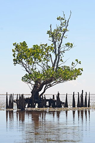
A mangrove is a shrub or tree that grows mainly in coastal saline or brackish water. Mangroves grow in an equatorial climate, typically along coastlines and tidal rivers. They have special adaptations to take in extra oxygen and to remove salt, which allow them to tolerate conditions that would kill most plants. The term is also used for tropical coastal vegetation consisting of such species. Mangroves are taxonomically diverse, as a result of convergent evolution in several plant families. They occur worldwide in the tropics and subtropics and even some temperate coastal areas, mainly between latitudes 30° N and 30° S, with the greatest mangrove area within 5° of the equator. Mangrove plant families first appeared during the Late Cretaceous to Paleocene epochs, and became widely distributed in part due to the movement of tectonic plates. The oldest known fossils of mangrove palm date to 75 million years ago.

The Coral Sea is a marginal sea of the South Pacific off the northeast coast of Australia, and classified as an interim Australian bioregion. The Coral Sea extends 2,000 kilometres (1,200 mi) down the Australian northeast coast. Most of it is protected by the French Natural Park of the Coral Sea and the Australian Coral Sea Marine Park. The sea was the location for the Battle of the Coral Sea, a major confrontation during World War II between the navies of the Empire of Japan, and the United States and Australia.

Araucaria is a genus of evergreen coniferous trees in the family Araucariaceae. While today they are largely confined to the Southern Hemisphere, during the Jurassic and Cretaceous they were distributed globally. There are 20 extant species in New Caledonia, Norfolk Island, eastern Australia, New Guinea, Argentina, Brazil and Chile.

The Ganges Delta is a river delta in Eastern South Asia predominantly covering the Bengal region of the subcontinent, consisting of Bangladesh and the Indian state of West Bengal. It is the world's largest river delta and it empties into the Bay of Bengal with the combined waters of several river systems, mainly those of the Brahmaputra river and the Ganges river. It is also one of the most fertile regions in the world, thus earning the nickname the Green Delta. The delta stretches from the Hooghly River east as far as the Meghna River.

Sundarbans is a mangrove area in the delta formed by the confluence of the Ganges, Brahmaputra and Meghna Rivers in the Bay of Bengal. Sundarban Reserve Forest (SRF) of Bangladesh is the largest mangrove forest in the world. It spans the area from the Baleswar River in Bangladesh's division of Khulna to the Hooghly River in India's state of West Bengal. It comprises closed and open mangrove forests, land used for agricultural purpose, mudflats and barren land, and is intersected by multiple tidal streams and channels. Sundarbans is home to the world's largest area of mangrove forests. Four protected areas in the Sundarbans are enlisted as UNESCO World Heritage Sites, viz. Sundarbans West (Bangladesh), Sundarbans South (Bangladesh), Sundarbans East (Bangladesh) and Sundarbans National Park (India).

Caledonia was the Latin name used by the Roman Empire to refer to the part of Scotland that lies north of the River Forth, which includes most of the land area of Scotland. Today, it is used as a romantic or poetic name for all of Scotland. During the Roman Empire's occupation of Scotland, the area they called Caledonia was physically separated from the rest of the island by the Antonine Wall. The Romans several times invaded and occupied it, but unlike the rest of the island, it remained outside the administration of Roman Britain.
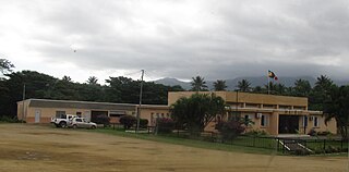
Poya is a commune in New Caledonia, an overseas territory of France in the Pacific Ocean. The largest part of the commune lies in the North Province of New Caledonia, and a smaller part of the commune lies in the South Province, an odd situation resulting from the creation of New Caledonia's provinces in 1989. At the 2019 census, 2,592 of the 2,802 inhabitants of Poya lived on the North Province's side of the commune, while only 210 inhabitants lived on the South Province's side.

The Gulf Country or North West Queensland is the region of woodland and savanna grassland surrounding the Gulf of Carpentaria in north western Queensland and eastern Northern Territory on the north coast of Australia. The region is also called the Gulf Savannah. The Gulf Country is crossed by the Savannah Way highway.
Poya Bay or Baie de la Poya, also known as Porwi Bay, is a bay of New Caledonia.
The Ouenghi River is a river of New Caledonia. It has a catchment area of 270 square kilometres. Bouloupais lies near the river at the foot of Mount Ouitchambo. It enters the Saint Vincent Bay to the west of the village of Tomo.
The Amoa River is a river of northeastern New Caledonia. It forms a prominent valley. It has a catchment area of 182 square kilometres.
Teremba Bay or Baie Teremba, formerly known as Uarai Bay, is a bay in southwestern New Caledonia. Moindou Bay lies to the west and Chanbeyron Bay lies to the southeast, separated by Lebris Island. The La Foa River enters the sea through a swampy area at Teremba Bay from the northeast. A notable fort, Fort Teremba, known as being a prison for deportees, lies opposite the river mouth. On July 12, 1922, France II ran aground on the bay's reef.

Sonneratia caseolaris, commonly known as mangrove apple, is a species of plant in the family Lythraceae. The fruit is noted for its outward similarity to the persimmon fruit.
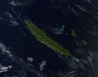
Grande Terre is the largest and principal island of New Caledonia, which is a territory of France.
Ndokoa Gorge is a gorge in New Caledonia. It lies at an altitude of about 330 metres (1,080 ft) above sea level near Mount Kaala, to the north of the Poya River.
Mount Aopinie is a mountain of central New Caledonia, with an elevation of 1,000 metres (3,300 ft).

Ceriops tagal, commonly known as spurred mangrove or Indian mangrove, is a mangrove tree species in the family Rhizophoraceae. It is a protected tree in South Africa. The specific epithet tagal is a plant name from the Tagalog language.
The Caledonia River is a perennial river of the West Gippsland catchment, located in the Alpine region of the Australian state of Victoria.

The geology of New Caledonia includes all major rock types, which here range in age from ~290 million years old (Ma) to recent. Their formation is driven by alternate plate collisions and rifting. The mantle-derived Eocene Peridotite Nappe is the most significant and widespread unit. The igneous unit consists of ore-rich ultramafic rocks thrust onto the main island. Mining of valuable metals from this unit has been an economical pillar of New Caledonia for more than a century.
References
- ↑ United States. Hydrographic Office (1952). Sailing directions for the Pacific islands. G.P.O. p. 46. Retrieved 13 May 2012.
- ↑ Spalding, Mark; Kainuma, Mami; Collins, Lorna (30 August 2010). World Atlas of Mangroves. Earthscan. p. 163. ISBN 978-1-84407-657-4 . Retrieved 13 May 2012.
- ↑ Aubréville, André (2002). Flore de la Nouvelle-Calédonie et dépendances: Pittosporaceae. Muséum national d'histoire naturelle. p. 86. ISBN 978-2-85654-213-2 . Retrieved 13 May 2012.