Related Research Articles

New Caledonia is a special collectivity of France in the southwest Pacific Ocean, south of Vanuatu, about 1,210 km (750 mi) east of Australia and 17,000 km (11,000 mi) from Metropolitan France. The archipelago, part of the Melanesia subregion, includes the main island of Grande Terre, the Loyalty Islands, the Chesterfield Islands, the Belep archipelago, the Isle of Pines, and a few remote islets. The Chesterfield Islands are in the Coral Sea. French people, especially locals, call Grande Terre Le Caillou.
Cheboygan is a city in the U.S. state of Michigan. As of the 2010 census, the city population was 4,876. It is the county seat of Cheboygan County.

Carthage is a village located in the town of Wilna in Jefferson County, New York, United States. The population was 3,747 at the 2010 census. The village is named after the historic city of Carthage in Tunisia.

The Coral Sea is a marginal sea of the South Pacific off the northeast coast of Australia, and classified as an interim Australian bioregion. The Coral Sea extends 2,000 kilometres (1,200 mi) down the Australian northeast coast. The sea was the location for the Battle of the Coral Sea, a major confrontation during World War II between the navies of the Empire of Japan, and the United States and Australia.

St. Johnsbury is the shire town of Caledonia County, Vermont, United States. The population was 7,603 at the 2010 census. St. Johnsbury is located approximately 10 miles (16 km) northwest of the Connecticut River and 48 miles (77 km) south of the Canada–U.S. border.

Admiralty Bay is an irregular bay, 8 km (5 mi) wide at its entrance between Demay Point and Martins Head, indenting the southern coast of King George Island for 16 km (10 mi), in the South Shetland Islands of Antarctica. The name appears on a map of 1822 by Captain George Powell, a British sailor, and is now established in international usage. The Henryk Arctowski Polish Antarctic Station is situated on the bay, as is the Comandante Ferraz Brazilian Antarctic Base. It has been designated an Antarctic Specially Managed Area.
Facheux Bay was the location of a small fishing settlement of the same name. In 1901 it had a population of 47. The community was also called Fachier, Facheaux, and Fouche. Facheux Bay is a deep fjord that separates Eastern Head and Western Head of Hermitage Bay, Newfoundland, Canada. Facheux bay is 2.25 miles (3.62 km) west of Mosquito Cove. The entrance is between two steep falls in high hills. The bay runs in 6.5 miles (10.5 km), with an average width of 0.75 miles (1.21 km), and has deep water throughout. On the west side are three coves with anchorage in 20 to 10 fathoms.

Chesterfield Islands are a French archipelago of New Caledonia located in the Coral Sea, 550 km northwest of Grande Terre, the main island of New Caledonia. The archipelago is 120 km long and 70 km broad, made up of 11 uninhabited islets and many reefs. The land area of the islands is less than 10 km².

USS Mobjack (AVP-27/AGP-7) was a motor torpedo boat tender in commission in the United States Navy from 1943 to 1946. She saw service in the Pacific theater during the latter portion of World War II.

The borders of the oceans are the limits of Earth's oceanic waters. The definition and number of oceans can vary depending on the adopted criteria. The principal divisions of the five oceans are the: Pacific Ocean, Atlantic Ocean, Indian Ocean, Southern (Antarctic) Ocean, and Arctic Ocean. Smaller regions of the oceans are called seas, gulfs, bays, straits, and other terms. Geologically, an ocean is an area of oceanic crust covered by water.
Nekoro Bay or Baie Nekoro is a bay in southwestern New Caledonia. It lies just northwest of Porwi Bay. The town of Nepoui and Nepoui Airport lie on the coast at Nekoro Bay.The bay contains Grimault Island and Hiyé Hiyé Island. Blancbe Bay lies just to the northwest.
Chasseloup Bay or Baie Chasseloup is a bay in northwestern New Caledonia. It lies northwest of Katavilli Bay and southeast of Gomen Bay. The town of Voh lies to the east of the bay. Several rivers empty into the bay. A small coral reef with a least depth of 5 feet lies 1200 yards westward of the middle of the head of Chasseloup Bay. Puangue Channel is westward of Chasseloup bay and forms a curve about 2J miles in length. It is reportedly the only way within the outer reef by which a vessel can pass to the northward. Anchorage in the bay is said to be good.

Tautira Bay is located on the island of Tahiti in French Polynesia. It is part of the commune Taiarapu-Est. It is formed by Tautira Point and reef on the eastern side, and by the barrier reef on the western side. It is reached through a gap in the reef about half a mile wide, with deep water, with Tautira point giving it protection from winds from north-east. It is 0.5 miles (0.80 km) wide and about the same depth. The bay opens to the northwest, affording protection with winds from northeastward through east and south to west-northwestward, but can be dangerous with those between north and west-northwestward. James Cook anchored several times in this bay, from which circumstance the name is derived. The depth in the middle of the entrance is from 35 to 60 fathoms, diminishing gradually to the shore. The bay is clear, except a small patch of 2 fathoms 600 feet (180 m) southward of the point of reef on the western side. The eastern and southeastern shore is lined with a sandy beach. The best anchorage is at about 1,200 feet (370 m) from the shore in 8.5 fathoms, sand, with the extreme of Tautira Point bearing 45°.

Ataliklikun Bay is a bay of East New Britain Province, Papua New Guinea, opening into the Bismarck Sea. It is located in the northern part of New Britain, south-west of Lassul Bay and to the west of Cape Lambert and Rabaul. Urara Island is located in the northern part of the bay. The Raulavat plantation lies in the eastern part of its 25-mile shoreline. The villagers along the shore reportedly speak the Minigir language and the Masava dialect of Tolai. The United States Hydrographic Office said "a reef awash, about 200 yards long east and west, with 15 and 19 fathoms around, on which the steamer Seestem struck in 1909, lies in the south-west part of Ataliklikun Bay."

Urara Island is a small inhabited island in the northern part of Ataliklikun Bay in Papua New Guinea, located just off the mainland of the northern coast of New Britain. There are 3 villages, the largest lying on the southern central part of the coastline. Urara Island lies about 3 miles westward of Cape Liguan, and stands on a reef which extends a short distance only eastward of it and 1.5 miles to the westward. Materbert Island lies about 6 miles west of the island and Watom Island lies to the north-east.

Mortier Bay is a natural bay on the Burin Peninsula on the south coast of the island of Newfoundland in the province of Newfoundland and Labrador, Canada. It is entered through a channel 1.5 miles (2.4 km) long and 0.5 miles (0.80 km)wide, at the north end of which the bay opens nearly 2 miles (3.2 km) in diameter with deep water and no anchorage, except in the harbors off it. The settlement of Marystown is located on the bay.
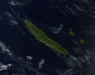
Grande Terre is the largest and principal island of New Caledonia, which is a territory of France.
The Poya River is a river of western-central New Caledonia. Its source lies near Mount Aopinie. The town of Poya lies on the river bank not far from the sea. The river mouth at Poya Bay is characterised by large mangroves.
Mount Aopinie is a mountain of central New Caledonia, with an elevation of 550 metres (1,800 ft).
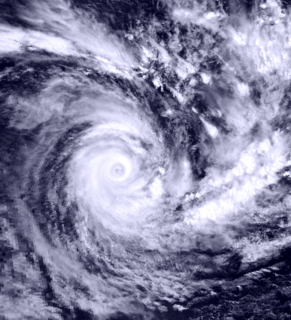
Severe Tropical Cyclone Drena was a powerful tropical cyclone that caused significant damage throughout New Zealand. A tropical depression formed on January 2, 1997. After crossing Vanuatu and emerging into the Coral Sea, the storm began to intensify, and by January 6, had attained peak intensity. After attaining peak intensity, Drena began to weaken. Cyclone Drena later brushed New Caledonia, bringing some damage. After transitioning into an extratropical cyclone on January 9, Drena brought impact to New Zealand. Damage totaled to $6.7 million and 3 people were killed. Roughly 140 people were evacuated after 44 homes were flooded. After the season, Drena was retired.
References
- ↑ "The impacts of opencast mining in New Caledonia". The United Nations University. Archived from the original on 27 July 2011. Retrieved 9 June 2011.CS1 maint: discouraged parameter (link)
- ↑ United States. Hydrographic Office (1928). Pacific islands pilot. U.S. Govt. Print. Off. Retrieved 10 June 2011.CS1 maint: discouraged parameter (link)
- ↑ United States. Hydrographic Office (1952). Sailing directions for the Pacific islands. G.P.O. Retrieved 10 June 2011.CS1 maint: discouraged parameter (link)
Coordinates: 21°25′S165°05′E / 21.417°S 165.083°E
| | This New Caledonian location article is a stub. You can help Wikipedia by expanding it. |