Praia da Aguda

Last updated

Aguda Beach (Praia da Aguda in Portuguese) is a small fishermen village located at about 13 km south of the city of Porto, in Arcozelo, a parish of Vila Nova de Gaia Municipality. It is known for its wide sandy beach (FEE Blue Flag beach) [1] and for its sea waters reach in marine life. Actually its waters are also, highly appreciated for therapeutics due to its high iodine content.

Porto Municipality in Norte, Portugal

Porto is the second-largest city in Portugal after Lisbon and one of the major urban areas of the Iberian Peninsula. The city proper has a population of 287,591 and the metropolitan area of Porto, which extends beyond the administrative limits of the city, has a population of 2.3 million (2011) in an area of 2,395 km2 (925 sq mi), making it the second-largest urban area in Portugal. It is recognized as a gamma-level global city by the Globalization and World Cities (GaWC) Study Group, the only Portuguese city besides Lisbon to be recognised as a global city.

Arcozelo (Vila Nova de Gaia) Civil parish in Norte, Portugal

Arcozelo is a freguesia in the municipality (concelho) of Vila Nova de Gaia. The population in 2011 was 14,352, in an area of 8.50 km².

Blue Flag beach Certification for high quality beaches

The Blue Flag is a certification by the Foundation for Environmental Education (FEE) that a beach, marina, or sustainable boating tourism operator meets its stringent standards.

Contents

Aguda Beach is one of the most calm and beloved beaches of Porto, and one of the most beautiful beaches of Costa Verde.

Costa Verde (Portugal) human settlement in Portugal

Costa Verde is a tourist and coastal region of northwest Portugal.

History

In mid-nineteenth century Aguda was a small group of wooden barracks that housed the fishermen engaged in the fish capture in this area. [2]

It was the introduction of the railway in 1864, that triggered the development of the small fishing core. With better accessibility the place quickly began to attract more people, especially during the summer, frequenting the beach. Among them, some of the wealthiest families of Porto, that began to build summer mansions on the place.

One of the earliest and most illustrious was Jorge Correia, owner of Vila Palmeira, recently renamed Roses Village (Vila Rosa in Portuguese). Jorge Correia, together with João Gomes da Silva Guerra, a real state builder of the region, were responsible for the urbanization plan of Aguda Beach, that involved the opening of new streets and the replacement of the wooden barracks for stone houses for the fishermen. Thus arose the Rua dos Pescadores (Fishermen Street), the first cluster of whitewashed houses. In 1912 the opening of an avenue linking the railway to the beach, definitely marked the development and urbanization of the place. In 1949 this avenue was named Jorge Correia, in his honour. [3] Coordinates: 41°02′56″N8°39′11″W / 41.049°N 8.653°W / 41.049; -8.653

Geographic coordinate system Coordinate system

A geographic coordinate system is a coordinate system that enables every location on Earth to be specified by a set of numbers, letters or symbols. The coordinates are often chosen such that one of the numbers represents a vertical position and two or three of the numbers represent a horizontal position; alternatively, a geographic position may be expressed in a combined three-dimensional Cartesian vector. A common choice of coordinates is latitude, longitude and elevation. To specify a location on a plane requires a map projection.

Notes

  1. "Blue Flag - Aguda". Praia da Aguda's listing on the Blue Flag listing site. The Foundation for Environmental Education. Retrieved 26 April 2015.
  2. Pinho Nunes, F. (1954). Monografia da Praia da Aguda. Vila Nova de Gaia. p. 5.
  3. Weber, Jesus, Santos, Mike, Paulo, Assunção (2002). Cem anos na Praia da Aguda. Porto: Edições Afrontamento. p. 91. ISBN   978-972-36-0567-9.CS1 maint: Multiple names: authors list (link)

Related Research Articles

Praia City in Santiago

Praia, is the capital and largest city of Cape Verde, an island nation in the Atlantic Ocean west of Senegal. It lies on the southern coast of Santiago island in the Sotavento Islands group. It is the island's ferry port and is home to one of the nation's four international airports. The city centre is known as Plateau due to its location on a small plateau.

Vila Nova de Gaia Municipality in Norte, Portugal

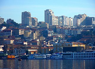
Vila Nova de Gaia, or simply Gaia, is a city and a municipality in Porto District in Norte Region, Portugal. It is located south of the city of Porto on the other side of the Douro River. The city proper had a population of 178,255 in 2001. The municipality has an area of 168.46 km². and a total population of 302,295 inhabitants (2011), making it the most populous municipality in Norte Region. Gaia together with Porto and 12 other municipalities makes up the commonly designated Porto Metropolitan Area.

Valadares (Vila Nova de Gaia) Civil parish in Portugal

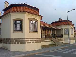
Valadares is a former civil parish in the municipality of Vila Nova de Gaia, Portugal. In 2013, the parish merged into the new parish Gulpilhares e Valadares. The population in 2011 was 10,678, in an area of 5.14 km².

Vila Nova may refer to the following places:

Miramar, Portugal village in Portugal

Miramar is a small seaside village near the towns of Gulpilhares and Arcozelo, in the municipality of Vila Nova de Gaia, in the subregion of Greater Porto, Portugal.

Porto Covo Civil parish in Alentejo, Portugal

Porto Covo is one of the two civil parishes in the municipality of Sines, located along the western Alentejo coast of Portugal, about 170 km (110 mi) south of Lisbon. The population in 2011 was 1,038, in an area of 50.72 km². Known for its beaches and ties to the ocean, the name Porto Covo likely translates as port of the covos, the term covo referring to a fishing net, used for capturing lobsters and crabs.

São Félix da Marinha Civil parish in Norte, Portugal

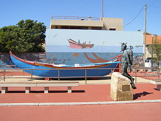
São Félix da Marinha is a Portuguese town and a parish in the municipality of Vila Nova de Gaia, in the district of Porto, in Northern Portugal. The population in 2011 was 12,706, in an area of 7.93 km².

Praia da Granja

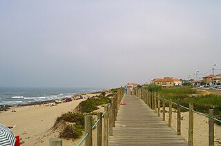
Praia da Granja is a FEE Blue Flag beach located in the Northwest of Portugal, and belongs to the Vila Nova de Gaia municipality, Porto District. This place is also located in the town of São Félix da Marinha. The northern boundary of the beach is bordered by the Ribeira da Granja.

Manuel Jorge da Silva Cruz, known as Tulipa, is a Portuguese retired footballer who played as a midfielder, and is a manager.

Fort of São João Baptista of Praia Formosa

The Fort of São João Baptista is the ruins of a 16th-century maritime fort situated on the western edge of Praia Formoso, in the civil parish of Almagreira, municipality of Vila do Porto, on the Portuguese island of Santa Maria.

Augusto Santos Silva Portuguese politician, school teacher and journalist

Augusto Ernesto dos Santos Silva, OMRI is the Portuguese Minister of Foreign Affairs and a university professor.

Vila Nova de Gaia is one of the leading tourism destinations in northern Portugal, located directly opposite Porto, on the South bank of Douro river. These two cities interconnect with each other through several bridges over Douro river. Vila Nova de Gaia is home to several notable attractions, such as the Port wine cellars, Dom Luís I Bridge, the Teleferico, Monastery of Serra do Pilar, Douro Estuary and 18 km long beaches.

References

See also