
Stutsman County is a county in the U.S. state of North Dakota. As of the 2020 census, the population was 21,593. Its county seat is Jamestown.

A marsh is — according to ecological definitions — a wetland that is dominated by herbaceous rather than woody plant species. More in general, the word can be used for any low-lying and seasonally waterlogged terrain. In Europe and in agricultural literature low-lying meadows that require draining and embanked polderlands are also referred to as marshes or marshland.
The Missouri Coteau, or Missouri Plateau, is a large plateau that stretches along the eastern side of the valley of the Missouri River in central North Dakota and north-central South Dakota in the United States. In the Canadian provinces of Saskatchewan and Alberta this physiographic region is classified as the Uplands Missouri Coteau, which is a part of the Great Plains Province or Alberta Plateau Region, which extends across the southwest corner of the province of Saskatchewan as well as the southeast corner of the province of Alberta. Historically, in Canada the area was known as the Palliser's Triangle and regarded as an extension of the Great American Desert and unsuitable for agriculture and thus designated by Canadian geographer and explorer John Palliser. The terrain of the Missouri Coteau features low hummocky, undulating, rolling hills, potholes, and grasslands. Apart from being a geographical area, the Missouri Coteau also has a cultural connection to the people of the area, the Métis people of South Dakota, along with other Indigenous groups. The history of this plateau is large, and the Missouri Coteau has a significance to these people.

A kettle is a depression or hole in an outwash plain formed by retreating glaciers or draining floodwaters. The kettles are formed as a result of blocks of dead ice left behind by retreating glaciers, which become surrounded by sediment deposited by meltwater streams as there is increased friction. The ice becomes buried in the sediment and when the ice melts, a depression is left called a kettle hole, creating a dimpled appearance on the outwash plain. Lakes often fill these kettles; these are called kettle hole lakes. Another source is the sudden drainage of an ice-dammed lake and when the block melts, the hole it leaves behind is a kettle. As the ice melts, ramparts can form around the edge of the kettle hole. The lakes that fill these holes are seldom more than 10 m (33 ft) deep and eventually fill with sediment. In acid conditions, a kettle bog may form but in alkaline conditions, it will be kettle peatland.

Paynes Prairie Preserve State Park is a Florida State Park, encompassing a 21,000-acre (85 km2) savanna in Alachua County, Florida lying between Micanopy and Gainesville. It is also a U.S. National Natural Landmark. It is crossed by both I-75 and U.S. 441. It is in the center of the Paynes Prairie Basin. The basin's primary source of drainage is Alachua Sink. During occasional wet periods, the basin will become full. A notable period occurred from 1871 to 1891 when the Alachua Sink was temporarily blocked. During this period, shallow draft steamboats were a frequent sight on Alachua Lake in the center of the prairie. The region was also historically known as the Alachua Savannah. Its drainage has been modified by several canals. Since 1927, Camps Canal has linked the basin to the River Styx which leads to Orange Lake and eventually the Atlantic Ocean through the St. Johns River. That reduced the basins water intake by half. Additional changes to the prairie's environment have been detrimental to its hydrology. In 1970, the state of Florida acquired the land and has been in the process of restoring the environment to a more natural condition ever since.
Ducks Unlimited (DU) is an American 501(c)(3) nonprofit organization dedicated to the conservation of wetlands and associated upland habitats for waterfowl, other wildlife, and people. It has had a membership of around 700,000 since January 2013.

The University of Wisconsin–Madison Arboretum is a teaching and research facility of the University of Wisconsin–Madison and the site of historic research in ecological restoration. In addition to its 1,260 acres (5 km2) in Madison, Wisconsin, the Arboretum also manages 520 acres (210 ha) of remnant forests and prairies throughout Wisconsin. It was designated a National Historic Landmark in 2021, in recognition for its role as a pioneer in the field of ecological restoration.
The Chase Lake Prairie Project is an effort to restore and protect the largest remaining region in the lower 48 states for waterfowl production. Located in U.S. state of North Dakota and consisting of 5,500,000 acres (22,000 km2) spread across 11 counties, this region is composed of thousands of lakes and ponds and grassland prairie. 97% of the land area is privately owned, with the U.S. Fish and Wildlife Service working with landowners to protect wetlands and associated prairie regions in a collaborative effort to ensure the region continues to provide habitat for the millions of birds and other wildlife that are dependent on the ecosystem.
The Valley City Wetland Management District is located in the U.S. state of North Dakota and consists of 76,000 acres (307 km2). The wetland district is a substation of the Arrowwood National Wildlife Refuge Complex, overseen by the U.S. Fish and Wildlife Service. 82 waterfowl production areas and four separate national wildlife refuges which are privately owned are in turn managed by the wetland district as easement refuges. The wetland district is in portions of 5 counties in the Prairie Pothole Region that was created by the retreat of glaciers 12,000 years ago, during the last glacial maximum. One third of the protected lands are wetlands with the balance consisting of prairie.
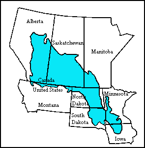
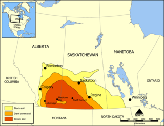
The Prairie Pothole Region is an expansive area of the northern Great Plains that contains thousands of shallow wetlands known as potholes. These potholes are the result of glacier activity in the Wisconsin glaciation, which ended about 10,000 years ago. The decaying ice sheet left behind depressions formed by the uneven deposition of till in ground moraines. These depressions are called potholes, glacial potholes, kettles, or kettle lakes. They fill with water in the spring, creating wetlands, which range in duration from temporary to semi-permanent. The region covers an area of about 800,000 sq. km and expands across three Canadian provinces and five U.S. states. The hydrology of the wetlands is variable, which results in long term productivity and biodiversity. The PPR is a prime spot during breeding and nesting season for millions of migrating waterfowl.

National Ecological Observatory Network (NEON) is a large facility program operated by Battelle Memorial Institute and funded by the National Science Foundation. In full operation since 2019, NEON gathers and provides long-term, standardized data on ecological responses of the biosphere to changes in land use and climate, and on feedback with the geosphere, hydrosphere, and atmosphere. NEON is a continental-scale research platform for understanding how and why our ecosystems are changing.

A biosurvey, or biological survey, is a scientific study of organisms to assess the condition of an ecological resource, such as a water body.

Straddling the headwaters of the Minnesota River in west-central Minnesota, Big Stone National Wildlife Refuge is within the heart of the tallgrass prairie's historic range. Today, less than one-percent of tallgrass prairie remains.

Tewaukon National Wildlife Refuge is located in southeastern North Dakota along the western edge of the northern tallgrass prairie, about 5 miles (8.0 km) south of Cayuga, in Sargent County. The Wild Rice River flows through the Refuge and then into Lake Tewaukon. Established in 1945, the 8,363-acre (33.84 km2) Refuge is located in the Prairie Pothole Region, one of the most biologically productive areas on earth. It lies within the Tewaukon Wetland Management District.
Detroit Lakes Wetland Management District is located in northwest Minnesota and includes the counties of Becker, Clay, Mahnomen, Norman, and Polk - an area of approximately 6,000 square miles (16,000 km2). The district is divided into three general landscape areas, roughly equal in size. From west to east, these are: the Red River Valley floodplain, the glacial moraine/prairie pothole region, and the hardwood/coniferous forest. The district currently manages over 42,000 acres (170 km2) of public land in 165 waterfowl production areas (WPAs). Additionally, district staff are responsible for more than 300 wetland and upland easements on private property, totaling more than 11,000 acres (45 km2).

Long Lake Wetland Management District encompasses three counties in south-central North Dakota, an area famed for its wealth of waterfowl-producing potholes and native prairie grasslands. Headquarters for the Wetland Management District is located in the Long Lake National Wildlife Refuge office near Moffit, North Dakota, which is about 35 miles southeast of Bismarck. Topographical landforms of the area include Missouri Coteau and Missouri River Slope. Precipitation averages just under 16 inches per year. Approximately 68 percent of the land in the three county area remains virgin sod - native mixed-grass prairie. The dominant land use is cattle grazing. The Coteau wetlands found in the northeastern portion of the Wetland Management District are classic prairie potholes of various sizes and types that are prime duck production habitat. These areas, when wet, are very productive. Soils in this area are generally deep and quite productive. Due to the rolling nature of the landscape on the Coteau, a lot of the land is also characterized as highly erodible. Conversely, many of the wetlands on Missouri River Slope portion of the Wetland Management District are large semi-permanent and permanent alkali wetlands. There are 21 wetland sites on the Missouri River Slope that have a history of periodic avian botulism outbreaks. These areas occasionally present localized problems for significant numbers of migratory birds. Soils on the Missouri River Slope are characteristically shallow with high proportions of sand and gravel. Much of the land is highly erodible. Since 1985, substantial land acreage in the three county area that was once farmed has been retired to Conservation Reserve Program grasslands. The program has assisted in restoring waterfowl populations for many species in the Wetland Management District which exceed the highest level ever recorded since surveys began.
The effects of climate change in Saskatchewan are now being observed in parts of the province. There is evidence of reduction of biomass in Saskatchewan's boreal forests that is linked by researchers to drought-related water stress stemming from global warming, most likely caused by greenhouse gas emissions. While studies, as early as 1988 have shown that climate change will affect agriculture, whether the effects can be mitigated through adaptations of cultivars, or crops, is less clear. Resiliency of ecosystems may decline with large changes in temperature. The provincial government has responded to the threat of climate change by introducing a plan to reduce carbon emissions, "The Saskatchewan Energy and Climate Change Plan", in June 2007.
Last Mountain Lake Bird Sanctuary is a National Historic Site of Canada, located in the rural municipality of Last Mountain Valley No. 250 in Saskatchewan. The migratory bird sanctuary was the first established in North America. The 47.36 km2 (18.29 sq mi) area is within the Last Mountain Lake National Wildlife Area, an International Biological Program site, and includes adjacent uplands.

Prairie Lake is a terminal wetland lake found in Stutsman County, North Dakota. It is on land that is administered by the North Dakota Department of Trust Lands.

