Pravoševo

Last updated
Pravoševo
Village
Serbia adm location map.svg
Red pog.svg
Pravoševo
Coordinates: 43°22′N19°47′E / 43.367°N 19.783°E / 43.367; 19.783
CountryFlag of Serbia.svg  Serbia
District Zlatibor District
Municipality Prijepolje
Population (2002)
  Total 85
Time zone CET (UTC+1)
  Summer (DST) CEST (UTC+2)

Pravoševo is a village in the municipality of Prijepolje, Serbia. According to the 2002 census, the village has a population of 85 people. [1]

Village Small clustered human settlement smaller than a town

A village is a clustered human settlement or community, larger than a hamlet but smaller than a town, with a population ranging from a few hundred to a few thousand. Though villages are often located in rural areas, the term urban village is also applied to certain urban neighborhoods. Villages are normally permanent, with fixed dwellings; however, transient villages can occur. Further, the dwellings of a village are fairly close to one another, not scattered broadly over the landscape, as a dispersed settlement.
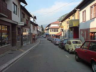
Prijepolje Town and municipality in Šumadija and Western Serbia, Serbia

Prijepolje is a town and municipality located in the Zlatibor District of southwestern Serbia. As of 2011 census, the town has 13,330 inhabitants, while the municipality has 37,059 inhabitants.

Serbia Republic in Southeastern Europe

Serbia, officially the Republic of Serbia, is a country situated at the crossroads of Central and Southeast Europe in the southern Pannonian Plain and the central Balkans. It borders Hungary to the north, Romania to the northeast, Bulgaria to the southeast, North Macedonia to the south, Croatia and Bosnia and Herzegovina to the west, and Montenegro to the southwest. The country claims a border with Albania through the disputed territory of Kosovo. Serbia's population numbers approximately seven million, most of whom are Orthodox Christians. Its capital, Belgrade, ranks among the oldest and largest citiеs in southeastern Europe.

Related Research Articles

Sucevița Commune in Suceava County, Romania

Sucevița is a commune in Suceava County, Romania. It is composed of two villages, Sucevița and Voievodeasa.

Ghelari Commune in Hunedoara County, Romania

Ghelari is a commune in Hunedoara County, Transylvania, Romania. It is composed of four villages: Ghelari, Govăjdia (Govasdia), Plop and Ruda.

Badovinci Village in Serbia

Badovinci is a village in Serbia. It is situated in the Bogatić municipality, in the Mačva District. The village has a Serb ethnic majority and its population numbering 5,406 people.

Drežnik (Užice) Village in Serbia

Drežnik is a village located in the Užice municipality of Serbia. In the 2002 census, the village had a population of 761.

Osdorp Neighborhood of Amsterdam in North Holland, Netherlands

Osdorp is neighbourhood of Amsterdam, Netherlands. A larger area was, from 1981 until 2010, a stadsdeel (borough) of Amsterdam and in 2010 was merged into the new borough of Amsterdam Nieuw-West.

Czekołdy Village in Podlaskie, Poland

Czekołdy is a village in the administrative district of Gmina Mońki, within Mońki County, Podlaskie Voivodeship, in northeastern Poland. It lies approximately 4 kilometres (2 mi) south of Mońki and 38 km (24 mi) north-west of the regional capital Białystok.

Vădastra Commune in Olt County, Romania

Vădastra is a commune in Olt County, Romania. It is composed of a single village, Vădastra. It also included Vișina Nouă village until 2004, when it was split off to form a separate commune.

Kazakhbarasi Place in Jalilabad, Azerbaijan

Kazakhbarasi is a village in the Jalilabad Rayon of Azerbaijan.

Qazaxbərəsi is a village in the municipality of Qaçaqkənd in the Neftchala Rayon of Azerbaijan.

Chestimensko is a village in Tervel Municipality, Dobrich Province, in northeastern Bulgaria.

Charkovo is a village in Gabrovo Municipality, in Gabrovo Province, in northern central Bulgaria.

Alin Potok Village in Zlatibor District, Serbia

Alin Potok is a village in the municipality of Čajetina, western Serbia. According to the 2011 census, the village has a population of 190 people.

Golovo Village in Zlatibor District, Serbia

Golovo is a village in the municipality of Čajetina, western Serbia. At the 2011 census, the village had a population of 169 people.

Kriva Reka (Čajetina) Village in Zlatibor District, Serbia

Kriva Reka is a village in the municipality of Čajetina, western Serbia. According to the 2011 census, the village has a population of 1,157 people.

Rakovica (Čajetina) Village in Zlatibor District, Serbia

Rakovica is a village in the municipality of Čajetina, western Serbia. According to the 2011 census, the village has a population of 60 people.

Rudine (Čajetina) Village in Zlatibor District, Serbia

Rudine is a village in the municipality of Čajetina, western Serbia. According to the 2011 census, the village has a population of 144 people.

Negbina Village in Zlatibor District, Serbia

Negbina is a village in the municipality of Nova Varoš, western Serbia. According to the 2002 census, the village has a population of 475 people.

Vrbnica (Sjenica) Village in Zlatibor District, Serbia

Vrbnica is a village in the municipality of Sjenica, Serbia. According to the 2002 census, the village has a population of 169 people.

Rzav (Višegrad) Village in Republika Srpska, Bosnia and Herzegovina

Rzav is a village in the municipality of Višegrad, Bosnia and Herzegovina.

Maslovsky, Maslovskaya, or Maslovskoye is the name of several rural localities in Russia.

References

  1. Popis stanovništva, domaćinstava i Stanova 2002. Knjiga 1: Nacionalna ili etnička pripadnost po naseljima. Republika Srbija, Republički zavod za statistiku Beograd 2003. ISBN   86-84433-00-9

Coordinates: 43°22′N19°47′E / 43.367°N 19.783°E / 43.367; 19.783

Geographic coordinate system Coordinate system

A geographic coordinate system is a coordinate system that enables every location on Earth to be specified by a set of numbers, letters or symbols. The coordinates are often chosen such that one of the numbers represents a vertical position and two or three of the numbers represent a horizontal position; alternatively, a geographic position may be expressed in a combined three-dimensional Cartesian vector. A common choice of coordinates is latitude, longitude and elevation. To specify a location on a plane requires a map projection.