Related Research Articles
The River Douglas, also known as the River Asland or Astland, flows through parts of Lancashire and Greater Manchester in North West England. It is a tributary of the River Ribble and has several tributaries, the major ones being the River Tawd and the River Yarrow.

Prescot is a town and civil parish within the Metropolitan Borough of Knowsley in Merseyside, United Kingdom. It lies about eight miles (13 km) to the east of Liverpool city centre. At the 2001 Census, the civil parish population was 11,184. The population of the larger Prescot East and West wards at the 2011 census totalled 14,139. Prescot marks the beginning of the A58 road which runs through to Wetherby, near Leeds in West Yorkshire. The town is served by Prescot railway station and Eccleston Park railway station in neighbouring Eccleston.

The M62 is a 107-mile-long (172 km) west–east trans-Pennine motorway in Northern England, connecting Liverpool and Hull via Manchester, Bradford, Leeds and Wakefield; 7 miles (11 km) of the route is shared with the M60 orbital motorway around Manchester. The road is part of the unsigned Euroroutes E20 and E22.

Thirlmere is a reservoir in the Borough of Allerdale in Cumbria and the English Lake District. The Helvellyn ridge lies to the east of Thirlmere. To the west of Thirlmere are a number of fells; for instance, Armboth Fell and Raven Crag both of which give views of the lake and of Helvellyn beyond.

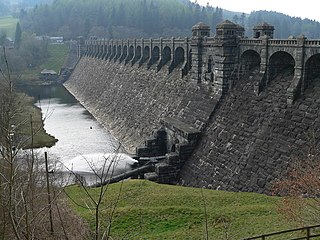
Lake Vyrnwy is a reservoir in Powys, Wales, built in the 1880s for Liverpool Corporation Waterworks to supply Liverpool with fresh water. It flooded the head of the Vyrnwy valley and submerged the village of Llanwddyn.
United Utilities Group plc (UU) is the United Kingdom's largest listed water company. It was founded in 1995 as a result of the merger of North West Water and NORWEB. The group manages the regulated water and waste water network in North West England, which includes Cumbria, Greater Manchester, Lancashire, Merseyside, most of Cheshire and a small area of Derbyshire, which have a combined population of more than seven million.

Anglezarke is a sparsely populated civil parish in the Borough of Chorley in Lancashire, England. It is an agricultural area used for sheep farming and is also the site of reservoirs that were built to supply water to Liverpool. The area has a large expanse of moorland with many public footpaths and bridleways. The area is popular with walkers and tourists; it lies in the West Pennine Moors in Lancashire, sandwiched between the moors of Withnell and Rivington, and is close to the towns of Chorley, Horwich and Darwen. At the 2001 census it had a population of 23, but at the 2011 census the population was included within Heapey civil parish. The area was subjected to depopulation after the reservoirs were built.

Anderton is a civil parish in the Borough of Chorley in Lancashire, England. It is now a suburb of Adlington, 5 miles (8 km) northwest of Bolton. Within its boundaries are the Rivington Reservoirs. Grimeford village is in the parish. In 2001, the parish had a population of 1,206, increasing to 1,316 at the 2011 census.
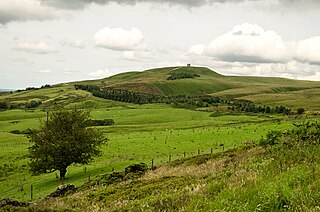
Rivington is a village and civil parish of the Borough of Chorley, Lancashire, England, occupying 2,538 acres. It is about 6 miles (9.7 km) southeast of Chorley and about 8+1⁄2 miles (13.7 km) northwest of Bolton. Rivington is a rural area consisting primarily of agricultural grazing land, moorland, with hill summits including Rivington Pike and Winter Hill within the West Pennine Moors. The area has a thriving tourist industry centred around reservoirs created to serve Liverpool in the Victorian era and Lever Park created as a public park by William Lever at the turn of the 20th century, with two converted barns, a replica of Liverpool Castle and open countryside. Rivington and Blackrod High School is located here. Rivington and its village had a population of 109 at the 2011 Census.

The West Pennine Moors is an area of the Pennines covering approximately 90 square miles (230 km2) of moorland and reservoirs in Lancashire and Greater Manchester, England. It is a Site of Special Scientific Interest.

Anglezarke Reservoir is the largest reservoir in the Rivington chain to the west of Anglezarke in Lancashire, England. Anglezarke Reservoir has three embankments: the Charnock Embankment, the longest, is 850 yards (777 m) long and 31 feet (9.45 m) high, the Knowsley Embankment is 240 yards (219.5 m) long and 45 feet (14 m) high and the Heapey Embankment is 280 feet (85.3 m) long and 32 feet (9.75 m) high. It is fed by the River Yarrow, which has been diverted from its original course which is now covered by the Knowsley Embankment. It served the city of Liverpool before its current status as a supply mainly for Wigan. The original `Rivington Pike Scheme' was undertaken by Thomas Hawksley between 1850 and 1857 for the Liverpool Corporation Waterworks. The scheme was to construct five reservoirs and a water treatment works at the south end of Lower Rivington with a 17-mile (27 km) pipeline to storage reservoirs at Prescot. Water from two higher level reservoirs, Rake Brook and Lower Roddlesworth, was carried south in `The Goit', a channel connecting them to the reservoirs.

Rivington Water Treatment Works is a water treatment plant in Rivington, Lancashire, England. It is located below the Lower Rivington Reservoir, the last in the Rivington chain of reservoirs. The first treatment works, a slow-sand filter plant on the site opened in 1860, supplying water to Liverpool. The present works was built in 1994, and in 2007 was the largest automated three-stage plant operated by United Utilities, the water is now disinfected by adding small amounts of chlorine. Most of its output supplies customers in the Wigan area.

The Street is a historical property on a bridleway of the same name in Heath Charnock in the Borough of Chorley, Lancashire, England. It is located on the western banks of the Upper Rivington reservoir and close to the boundary with the village of Rivington. It has been converted to apartments.
Lower Rivington Reservoir is at the end of the Rivington chain of reservoirs in Lancashire, England, with Upper Rivington Reservoir to the north, and Rivington Water Treatment Works to the south. The Rivington chain primarily supplies 70,000 households in the Wigan area. The chain was built to supply Liverpool.
Upper Roddlesworth Reservoir is a reservoir on the River Roddlesworth near Abbey Village in Lancashire, England.

Llanwddyn is a village and community in Montgomeryshire, Powys, Wales. The community is centred on the Lake Vyrnwy reservoir. The original Llanwddyn village, about 2 miles (3.2 km) northwest, was submerged when the reservoir was created in the 1880s.

Norton is an area in the eastern part of the town of Runcorn, Cheshire, England. It was originally a separate village 3 miles (5 km) to the east of Runcorn, but in the 1970s and 1980s became absorbed within Runcorn by the expansion of its new town.
The Last Days of Dolwyn is a 1949 British drama film directed by Emlyn Williams and starring Edith Evans, Emlyn Williams, Richard Burton and Anthony James. The screenplay focuses on an impoverished Welsh village which becomes the site of a bitter power struggle between a callous developer and a stubborn dowager.
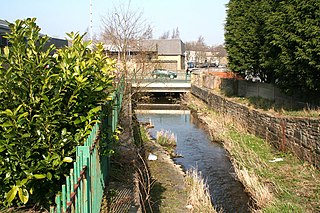
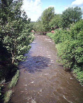
Walverden Water is a minor river in Lancashire, England. It is approximately 2.6 miles (4.2 km) long and has a catchment area of 5.04 square miles (1,304.23 ha).
Liverpool Corporation Waterworks and its successors have provided a public water supply and sewerage and sewage treatment services to the city of Liverpool, England. In 1625 water was obtained from a single well and delivered by cart, but as the town grew, companies supplied water to homes through pipes. There were two main companies by the 1840s, but the water supply was intermittent, and there was general dissatisfaction with the service. Liverpool Corporation decided that such an important service should be provided by a public body, and sought to take over the water supply companies.
References
Source: Moore, Jim. Underground Liverpool. The Bluecoat Press 1998. ISBN 1-872568-43-2