
The Dryanovo Monastery is a functioning Bulgarian Orthodox monastery situated in the Andaka River Valley, in Bulgarka Nature Park in the central part of Bulgaria five kilometers away from the town of Dryanovo. It was founded in the 12th century, during the Second Bulgarian Empire, and is dedicated to Archangel Michael. Twice burnt down and pillaged during the Ottoman rule of Bulgaria, the monastery was restored at it present place in 1845. It was the site of several battles during the April Uprising of 1876.

Kurta is an abandoned village in the former South Ossetian autonomous oblast of Georgia. Populated largely by ethnic Georgians, it was one of the towns that remained under the control of Georgia between the unilateral secession of South Ossetia after the 1991–1992 South Ossetia War and the 2008 South Ossetia War.

Inalegolo is a village in Kgalagadi District of Botswana. It is located in the north-east part of the district, in Kalahari Desert, and it has a primary school. The population was 533 in 2011 census. The chief of the village is Kgosi Seka Boraetsile.

Araks, is a village with 2,113 inhabitants (2001) in the western part of the Armavir Province of Armenia. It was founded as a state farm in 1940. The Battle of Sardarapat of 1918, took place near the village of Araks. In 1968, the Sardarapat Battle Memorial was erected on the site of the battle. Additionally there is the state owned Armenia Ethnography Museum.

Józefowo is a village in the administrative district of Gmina Nowinka, within Augustów County, Podlaskie Voivodeship, in north-eastern Poland. It lies approximately 5 kilometres (3 mi) north-west of Nowinka, 12 km (7 mi) north of Augustów, and 94 km (58 mi) north of the regional capital Białystok.
Hryćki is a village in the administrative district of Gmina Siemiatycze, within Siemiatycze County, Podlaskie Voivodeship, in northeastern Poland.
Wronowo is a village in the administrative district of Gmina Raczki, within Suwałki County, Podlaskie Voivodeship, in north-eastern Poland. It lies approximately 4 kilometres (2 mi) south of Raczki, 18 km (11 mi) south-west of Suwałki, and 96 km (60 mi) north of the regional capital Białystok.

Birinci Şordəhnə is a village in the Agdash Rayon of Azerbaijan.
Bəxtiyarlı is a village in the Qubadli Rayon of Azerbaijan. Bəxtiyarlı is the Azeri village in Qubadli
Tarovlu is a village in the Qubadli Rayon of Azerbaijan.
Kajetanów is a village in the administrative district of Gmina Wysokie, within Lublin County, Lublin Voivodeship, in eastern Poland.
Radomirka is a village in the administrative district of Gmina Wysokie, within Lublin County, Lublin Voivodeship, in eastern Poland.
Gródek is a village in the administrative district of Gmina Baranów, within Puławy County, Lublin Voivodeship, in eastern Poland.
Tchórzew-Kolonia is a village in the administrative district of Gmina Borki, within Radzyń Podlaski County, Lublin Voivodeship, in eastern Poland. It lies approximately 6 kilometres (4 mi) south of Borki, 15 km (9 mi) south-west of Radzyń Podlaski, and 47 km (29 mi) north of the regional capital Lublin.
Pucharki is a village in the administrative district of Gmina Tarnawatka, within Tomaszów Lubelski County, Lublin Voivodeship, in eastern Poland.
Knieja is a settlement in the administrative district of Gmina Karsin, within Kościerzyna County, Pomeranian Voivodeship, in northern Poland. It lies approximately 6 kilometres (4 mi) north-west of Karsin, 20 km (12 mi) south of Kościerzyna, and 67 km (42 mi) south-west of the regional capital Gdańsk.

Klečkovac is a village in the municipality of Sokolac, Bosnia and Herzegovina.
Bojince is a village in the municipality of Kruševac, Serbia. According to the 2002 census, the village has a population of 82 people.

Vodice is a village in the municipality of Smederevska Palanka, Serbia. According to the 2002 census, the village has a population of 930 people.
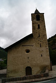
Església de Sant Joan de Sispony is a church located in Sispony, La Massana Parish, Andorra. It is a heritage property registered in the Cultural Heritage of Andorra. It was built in the 17th century.


