The Pacific-Antarctic Ridge is a divergent tectonic plate boundary located on the seafloor of the South Pacific Ocean, separating the Pacific Plate from the Antarctic Plate. It is regarded as the southern section of the East Pacific Rise in some usages, generally south of the Challenger Fracture Zone and stretching to the Macquarie Triple Junction south of New Zealand.
The East Pacific Rise (EPR) is a mid-ocean rise, at a divergent tectonic plate boundary, located along the floor of the Pacific Ocean. It separates the Pacific plate to the west from the North American plate, the Rivera plate, the Cocos plate, the Nazca plate, and the Antarctic plate. It runs south from the Gulf of California in the Salton Sea basin in Southern California to a point near 55°S130°W, where it joins the Pacific-Antarctic Ridge (PAR) trending west-south-west towards Antarctica, near New Zealand. Much of the rise lies about 3,200 km (2,000 mi) off the South American coast and reaches a height about 1,800–2,700 m (5,900–8,900 ft) above the surrounding seafloor.

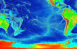
A mid-ocean ridge (MOR) is a seafloor mountain system formed by plate tectonics. It typically has a depth of about 2,600 meters (8,500 ft) and rises about 2,000 meters (6,600 ft) above the deepest portion of an ocean basin. This feature is where seafloor spreading takes place along a divergent plate boundary. The rate of seafloor spreading determines the morphology of the crest of the mid-ocean ridge and its width in an ocean basin.

The Phoenix plate was a tectonic plate that existed during the early Paleozoic through late Cenozoic time. It formed a triple junction with the Izanagi and Farallon plates in the Panthalassa Ocean as early as 410 million years ago, during which time the Phoenix plate was subducting under eastern Gondwana.

The Kerguelen hotspot is a volcanic hotspot at the Kerguelen Plateau in the Southern Indian Ocean. The Kerguelen hotspot has produced basaltic lava for about 130 million years and has also produced the Kerguelen Islands, Naturaliste Plateau, Heard Island, the McDonald Islands, the Comei large igneous province in south Tibet, and the Rajmahal Traps. One of the associated features, the Ninety East Ridge, is distinguished by its over 5,000 km (3,100 mi) length, being the longest linear tectonic feature on Earth. The total volume of magma erupted in 130 million years with associated features has been estimated to be about 25,000,000 km3 (6,000,000 cu mi). However, as well as large igneous provinces and seamounts the hotspot has interacted with other seafloor spreading features, so this volume figure has some uncertainty.

The Izu–Bonin–Mariana (IBM) arc system is a tectonic plate convergent boundary in Micronesia. The IBM arc system extends over 2800 km south from Tokyo, Japan, to beyond Guam, and includes the Izu Islands, the Bonin Islands, and the Mariana Islands; much more of the IBM arc system is submerged below sealevel. The IBM arc system lies along the eastern margin of the Philippine Sea Plate in the Western Pacific Ocean. It is the site of the deepest gash in Earth's solid surface, the Challenger Deep in the Mariana Trench.

The following outline is provided as an overview of and introduction to Oceanography.

The Owen Fracture Zone (OFZ), though misnamed as a fracture zone, is a transform fault in the northwest Indian Ocean that separates the Arabian and African plates from the Indian plate. Extending north-northeast from where the Carlsberg Ridge meets the Sheba ridge in the south to the Makran Subduction Zone in the north, it represents the port side of the northward motion of the Indian subcontinent during the Late Cretaceous–Palaeogene break-up of Gondwana. Slip along the Owen Fracture Zone is occurring at 2 mm (0.079 in)/yr, the slowest rate on Earth, which means the Arabian plate moves northward faster than the Indian plate.

The Rodrigues triple junction (RTJ), also known as the central Indian [Ocean] triple junction (CITJ) is a geologic triple junction in the southern Indian Ocean where three tectonic plates meet: the African plate, the Indo-Australian plate, and the Antarctic plate. The triple junction is named for the island of Rodrigues which lies 1,000 km (620 mi) north-west of it.

The Southwest Indian Ridge (SWIR) is a mid-ocean ridge located along the floors of the south-west Indian Ocean and south-east Atlantic Ocean. A divergent tectonic plate boundary separating the Somali plate to the north from the Antarctic plate to the south, the SWIR is characterised by ultra-slow spreading rates (only exceeding those of the Gakkel Ridge in the Arctic) combined with a fast lengthening of its axis between the two flanking triple junctions, Rodrigues (20°30′S70°00′E) in the Indian Ocean and Bouvet (54°17′S1°5′W) in the Atlantic Ocean.

The Southeast Indian Ridge (SEIR) is a mid-ocean ridge in the southern Indian Ocean. A divergent tectonic plate boundary stretching almost 6,000 km (3,700 mi) between the Rodrigues triple junction in the Indian Ocean and the Macquarie triple junction in the Pacific Ocean, the SEIR forms the plate boundary between the Australian and Antarctic plates since the Oligocene (anomaly 13).

The South American–Antarctic Ridge or simply American-Antarctic Ridge is the tectonic spreading center between the South American plate and the Antarctic plate. It runs along the sea-floor from the Bouvet triple junction in the South Atlantic Ocean south-westward to a major transform fault boundary east of the South Sandwich Islands. Near the Bouvet triple junction the spreading half rate is 9 mm/a (0.35 in/year), which is slow, and the SAAR has the rough topography characteristic of slow-spreading ridges.

The Macquarie triple junction is a geologically active tectonic boundary located at 61°30′S161°0′E at which the historic Indo-Australian plate, Pacific plate, and Antarctic plate collide and interact. The term triple junction is given to particular tectonic boundaries at which three separate tectonic plates meet at a specific, singular location. The Macquarie triple junction is located on the seafloor of the southern region of the Pacific Ocean, just south of New Zealand. This tectonic boundary was named in respect to the nearby Macquarie Island, which is located southeast of New Zealand.

The 1,600 kilometres (990 mi) long Macquarie Fault Zone is a major right lateral-moving transform fault along the seafloor of the south Pacific Ocean which runs from New Zealand southwestward towards the Macquarie Triple Junction. It is also the tectonic plate boundary between the Australian plate to the northwest and the Pacific plate to the southeast. As such it is a region of high seismic activity and recorded the largest strike-slip event on record up to 23 May 1989, of at least 8.0

Gondwana was a large landmass, sometimes referred to as a supercontinent. The remnants of Gondwana make up around two-thirds of today's continental area, including South America, Africa, Antarctica, Australia, Zealandia, Arabia, and the Indian Subcontinent.

Bollons Seamount or Bollons Tablemount is a seamount just east of the International Date Line, a few hundred miles off the coast of New Zealand. It represents a continental fragment that separated from Zealandia as a result of rifting. The seamount was involved in a 2002 survey and collection project defined to find the edge of New Zealand's continental shelf. The Bollons Seamount has been shown to be a site of extensive Cretaceous-era rifting in the area towards the southern Chatham Rise between 83.7 and 78.5 MYA.

Charlie–Gibbs fracture zone is a system of two parallel fracture zones. It is the most prominent interruption of the Mid-Atlantic Ridge between the Azores and Iceland, with the longest faults in the North Atlantic, and is ecologically an important biosystems boundary. It can be traced over more than 2,000 kilometres (1,200 mi), from north-east of Newfoundland to south-west of Ireland. It took 90 million years for the fault to grow to this length.

The Agulhas Basin is an oceanic basin located south of South Africa where the South Atlantic Ocean and south-western Indian Ocean meet. Part of the African plate, it is bounded by the Agulhas Ridge to the north and the Southwest Indian Ridge to the south; by the Meteor Rise to the west and the Agulhas Plateau to the east. Numerous bathymetric anomalies hint at the basin's dynamic tectonic history.
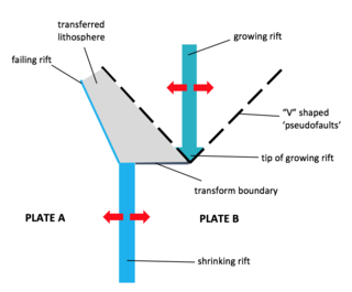
A propagating rift is a seafloor feature associated with spreading centers at mid-ocean ridges and back-arc basins. They are more commonly observed on faster rate spreading centers. These features are formed by the lengthening of one spreading segment at the expense of an offset neighboring spreading segment. Hence, these are remnant features produced by migration of the tip of a spreading center. In other words, as the tip of a spreading center migrates or grows, the plate itself grows at the expense of the shrinking plate, transferring lithosphere from the shrinking plate to the growing plate.

