
The Rural Municipality of Gimli is a rural municipality located in the Interlake Region of south-central Manitoba, Canada, on the western shore of Lake Winnipeg. It is about 75 kilometres (47 mi) north of the provincial capital Winnipeg. The rural municipality's population in the 2016 Canadian Census was 6,181, making it the 12th largest rural municipality by population. The RM of Gimli has an area of 318.75 km2 (123.07 sq mi), making it the sixth smallest rural municipality by area.
Lynn Lake is a town in the northwest region of Manitoba, Canada, approximately 1,071 km (665 mi) from Winnipeg. The town is the fourth-largest town in Manitoba in terms of land area. It is centred on the original urban community of Lynn Lake. The town was named after Lynn Smith, chief engineer of Sherritt Gordon Mines Ltd. There are many outfitters in the Lynn Lake area, offering services for most wilderness experiences, including sport fishing and bear and moose hunting.

Fort Resolution is a hamlet in the South Slave Region of the Northwest Territories, Canada. The community is situated at the mouth of the Slave River, on the shores of Great Slave Lake, and at the end of the Fort Resolution Highway. It is the headquarters of the Deninu Kųę́ First Nation, whose Chief is Louis Balsillie.

Gillam is a town on the Nelson River in northern Manitoba, Canada. It is situated between Thompson and Churchill on the Hudson Bay Railway line.
Snow Lake is a town in Manitoba, Canada, located 685 km north of Winnipeg at the end of Provincial Road 392. The main industry is, and always has been, mining; currently with one mine producing Zinc, and another lithium. The official Town of Snow Lake is a very large, overwhelmingly rural area that is centered about the urban community of Snow Lake, which lies very near its geographical center. The Town is as large in area as a typical rural municipality in the more southern parts of Manitoba.
Ashern is an unincorporated community recognized as a local urban district located in the Municipality of West Interlake in Manitoba's Interlake Region. The RM of Siglunes was incorporated in 1917. Ashern was named after A. S. Hern, a timekeeper of the firm that constructed the railway that served the Western Interlake.

Minaki is an unincorporated area and community in Unorganized Kenora District in northwestern Ontario, Canada. It is located at the point where the Canadian National Railways transcontinental main line crosses the Winnipeg River, between Wade to the west and Ena Lake at the east, and was accessible only by rail until about 1960. It was a fuelling and watering point in the days of steam locomotives; now few trains stop in Minaki, though the thrice-weekly Via Rail transcontinental Canadian passenger trains will stop on request at the Minaki railway station.

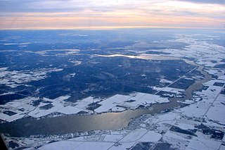
Lockport is a small unincorporated community in Manitoba, Canada. It is located 28 kilometres (17 mi) north of the city of Winnipeg along the Red River. The community is split between the Rural Municipalities of St. Andrews and St. Clements.

Ulukhaktok is a small hamlet on the west coast of Victoria Island, in the Inuvik Region of the Northwest Territories, Canada.
Ethelbert is an unincorporated urban community in the Municipality of Ethelbert, Manitoba, Canada.

Riverton is an unincorporated urban community in the Municipality of Bifrost – Riverton within the Canadian province of Manitoba that held village status prior to January 1, 2015. It is located approximately 110 kilometres north of Winnipeg. The CPR's train conductor is reputed to have named the community.
Pine Dock is a small fishing community by Lake Winnipeg in Manitoba, Canada. It had a population that was largest in the 1970s. Since this time its population has decreased. There is a small public beach and community town hall that continues to operate. During the 1970s to 1980s there was a small general store and a gas station, and an elementary school run by the Frontier School Division, however these are no longer operating. There is still a government dock and fishing station that continues to be used by local fishing industry. The next closest community is located on Matheson Island, Manitoba, that is 15 miles north of Pine Dock on Provincial Road 234, and accessed by a cable Ferry. South of Pine Dock are several recreational cottage developments including Beaver Creek Provincial Park (Manitoba), Mill Creek and Little Deer.

Island Lake is a small community in northeast Manitoba, Canada. The community consists of an archipelago near the north shore of Island Lake which includes the following islands: Stevenson, Wass, Hamilton, Boothe, Chapins, RC Mission, Gravel, and Lindsays.
Lac du Bonnet is a town in Manitoba, Canada located 115 km (71 mi) northeast of Winnipeg on the west shore of the Winnipeg River. It is surrounded by the Rural Municipality of Lac du Bonnet. The word "Bonnet" is pronounced by locals as "bonny."

Oak Lake is an unincorporated urban community in the Rural Municipality of Sifton within the Canadian province of Manitoba that held town status prior to January 1, 2015. It is located 52 km (32 mi) west of Brandon along the Trans-Canada Highway. The lake after which it was named is in the rural municipality's western area.

Victoria Beach is a rural municipality (RM) in the Eastman Region of Manitoba, Canada, located on the southeastern shores of Lake Winnipeg, approximately 100 kilometres (62 mi) north of Winnipeg.

Matheson Island is a community and an island located in the Canadian province of Manitoba, at the narrows of Lake Winnipeg. A designated place in Canadian census data, the community had a population of 136 in the 2021 Canadian census. Commercial fishing is the number one source of income for the community and area, the Matheson Island Marketing Co-Op works with approximately 110 local fishers.

Gimli is an unincorporated community in the Rural Municipality of Gimli on the west side of Lake Winnipeg in Manitoba, Canada. The community's first European settlers were Icelanders who were part of the New Iceland settlement in Manitoba. The community maintains a strong connection to Iceland and Icelandic culture today, including the annual Icelandic Festival. It was incorporated as a village on March 6, 1908, and held town status between December 31, 1946, and January 1, 2003, when it amalgamated with the RM of Gimli. Census Canada now recognizes the community as a population centre for census purposes. The 2021 Canadian census recorded a population of 2,345 in the population centre of Gimli.
