Related Research Articles

The Sabine River is a 360-mile (580 km) long river in the Southern U.S. states of Texas and Louisiana, From the 32nd parallel north and downstream, it serves as part of the boundary between the two states and empties into Sabine Lake, an estuary of the Gulf of Mexico.

Orange County is a county located in the very southeastern corner of the U.S. state of Texas, sharing a boundary with Louisiana, within the Golden Triangle of Texas. As of the 2020 census, its population was 84,808. The county seat is the city of Orange, and it falls within the Beaumont–Port Arthur metropolitan area.

Sabine County is a county located on the central eastern border of the U.S. state of Texas. As of the 2020 census, its population was 9,894. The county was organized on December 14, 1837, and named for the Sabine River, which forms its eastern border.

Newton County is the easternmost county in the U.S. state of Texas. As of the 2020 census, its population was 12,217. Its county seat is Newton. The county is named for John Newton, a veteran of the American Revolutionary War.

Sabine Parish is a parish located in the U.S. state of Louisiana. As of the 2020 census, the population was 22,155. The parish seat and largest town is Many.

Vinton is a town in Calcasieu Parish, Louisiana, United States. The population was 3,400 in 2020. It is part of the Lake Charles metropolitan statistical area.

Deweyville is a census-designated place (CDP) in Newton County, on the central eastern border of Texas, United States. The population was 571 at the 2020 census, down from 1,023 at the 2010 census.

Sabine Pass is the natural outlet of Sabine Lake into the Gulf of Mexico. It borders Jefferson County, Texas, and Cameron Parish, Louisiana.
Sabine Pass is a neighborhood in Port Arthur, Texas. It had been incorporated in 1861 before being formally annexed by Port Arthur in 1978. However, Sabine Pass retains its own distinct identity with its own school district, post office, and port authority. The Port Arthur Convention and Visitors Bureau stated that Sabine Pass is "often regarded as" being a "self-contained" community.
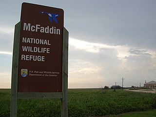
The McFaddin and Texas Point National Wildlife Refuges are located in proximity in southern Jefferson County on the upper Texas coast at Sabine Pass. The refuges have a combined 105.96 square miles (274.4 km2) of fish and wildlife habitat. McFaddin, much the larger one, located at around 29°40′00″N94°09′00″W, has a total area of 58,861.43 acres (238.2038 km2), while the smaller Texas Point, located at around 29°42′00″N93°53′00″W, has 8,952.02 acres (36.2275 km2).

Area code 409 is a telephone area code in the North American Numbering Plan (NANP) for the U.S. state of Texas. The numbering plan area comprises the Beaumont and Galveston areas. It was created on March 19, 1983, in an area code split of area code 713, the first since 619 split from 714 four months earlier. Initially, it consisted of a horseshoe-shaped area that almost completely surrounded Houston, but in 2000 it was divided into three sections. Area code 409 was retained by the eastern segment, while the central portion, centered on Nacogdoches, received area code 936 and the western portion centered on Bryan–College Station, was assigned area code 979.
Echo, Texas is a populated place which was founded in 1880. The Louisiana Western Extension Railroad Company was given the task of completing the last section of the Texas and New Orleans Railroad crossing the Sabine River, linking Houston with New Orleans. The swampland directly east of Orange was considered unsuitable for the railway construction, so the company pushed the line to the north and east and established a quarantine station. The site was given the name Echo, because the sounds of the railway reverberated in the nearby river swamp. Years later, the quarantine station would be removed, but this site located three miles northeast of Orange would still function as a freight yard for the Southern Pacific Railroad as well as an industrial site. In 1965, Echo would also be the construction starting point for the Sabine River and Northern Railroad, which would link the Southern Pacific to the Gulf, Colorado and Santa Fe Railway servicing the timber industry of the region.
Texla is a ghost town in northern Orange County, Texas, United States, in the southeastern part of the state. It is located northwest of Orange, just west of Mauriceville. The site was originally called Bruce, after the postmaster Charles G. Bruce, who served when the office opened in 1905. The first sawmill to operate there was known as the Harrell-Votaw Lumber Company with proximity to the Orange and Northwestern Railway. The following year, the R. W. Wier Lumber Company out of Houston took over operations. The site was renamed Texla, due to its proximity to Louisiana. The owner Wier sold out to the Miller-Link Lumber Company in 1917. The peak population of the town reached an estimated 600 residents. In 1918 the mill was destroyed by fire, but was rebuilt in 1919 with a double-circular mill of the same size. Within a year, the Peavy-Moore Lumber Company of Deweyville took ownership, and operated the site until the nearby timber became exhausted. In 1929, the mill was dismantled and the site was abandoned.
From 1945 until 1977, a sawmill operated under the name Texla Lumber Company in nearby Mauriceville, according to the Texas Forestry Museum.
Burkeville is an unincorporated community in northern Newton County, Texas, United States. It sits at the intersection of State Highways 63 and 87, 10 miles west of the Sabine River. The Burkeville Independent School District serves the resident students.
Mauldin or Mauldin Logging Camp is a ghost town in Montgomery County, Arkansas, United States. It is classified as a populated place. Established in 1918 by Billy Mauldin in cooperation with Thomas Rosborough, it became heavily populated by 1922 by workers drawn to industries cutting and processing virgin timber in the area. It was located between Mount Ida and Pencil Bluff.

Prairie Bluff, also known as Dale and Daletown, is a ghost town in Wilcox County, Alabama.
Belgrade is a ghost town in Newton County, in the U.S. state of Texas. Located near Farm to Market Road 1416 and one mile west of the Sabine River, Belgrade was a thriving community until the beginning of the Civil War. Now abandoned, a cemetery still remains, as well as a centennial marker. It was named after Belgrade, the capital of Serbia.

The Deweyville Swing Bridge, also known as Deweyville-Starks Swing Bridge and Sabine River Bridge, is a swing bridge which carries Texas State Highway 12 and Louisiana Highway 12 across the Sabine River at the Texas-Louisiana border. The bridge connects Deweyville, Texas to rural Calcasieu Parish, Louisiana, near the community of Starks. The Texas Highway Department and Louisiana Highway Commission built the bridge as a joint effort in 1936–38; the two highway departments used federal funding from Depression-era relief programs to complete the project. The bridge was one of four federally funded bridges between Texas and Louisiana built during the Great Depression. The swing bridge design, in which the center section of the bridge can rotate, allowed a variety of boats to pass by on the swift river. The bridge is the oldest surviving swing bridge of its design in Texas and one of three such bridges in the state.
Belzora is a ghost town located in Smith County, Texas, United States.
References
- ↑ Princeton, Texas: Handbook of Texas Online, University of Texas at Austin
Municipalities and communities of Newton County, Texas, United States | ||
|---|---|---|
| City |  | |
| CDPs | ||
| Other communities | ||
| Ghost towns | ||
30°19′34″N93°48′06″W / 30.3260°N 93.8018°W
| | This article about a location in Newton County, Texas is a stub. You can help Wikipedia by expanding it. |