Related Research Articles

A weather station is a facility, either on land or sea, with instruments and equipment for measuring atmospheric conditions to provide information for weather forecasts and to study the weather and climate. The measurements taken include temperature, atmospheric pressure, humidity, wind speed, wind direction, and precipitation amounts. Wind measurements are taken with as few other obstructions as possible, while temperature and humidity measurements are kept free from direct solar radiation, or insolation. Manual observations are taken at least once daily, while automated measurements are taken at least once an hour. Weather conditions out at sea are taken by ships and buoys, which measure slightly different meteorological quantities such as sea surface temperature (SST), wave height, and wave period. Drifting weather buoys outnumber their moored versions by a significant amount.

A severe thunderstorm watch is a statement issued by weather forecasting agencies to advise the public that atmospheric conditions in a given region may lead to the development of severe thunderstorms within the region over a period of several hours. The criteria for issuing a watch varies by country, and may also include torrential rainfall and tornadoes. A watch may also be issued several hours ahead of the arrival of a mature and organized complex of storms, or more clustered or discrete storm activity.

In meteorology, precipitation is any product of the condensation of atmospheric water vapor that falls from clouds due to gravitational pull. The main forms of precipitation include drizzle, rain, sleet, snow, ice pellets, graupel and hail. Precipitation occurs when a portion of the atmosphere becomes saturated with water vapor, so that the water condenses and "precipitates" or falls. Thus, fog and mist are not precipitation; their water vapor does not condense sufficiently to precipitate, so fog and mist do not fall. Two processes, possibly acting together, can lead to air becoming saturated with water vapor: cooling the air or adding water vapor to the air. Precipitation forms as smaller droplets coalesce via collision with other rain drops or ice crystals within a cloud. Short, intense periods of rain in scattered locations are called showers.
The National Weather Service (NWS) is an agency of the United States federal government that is tasked with providing weather forecasts, warnings of hazardous weather, and other weather-related products to organizations and the public for the purposes of protection, safety, and general information. It is a part of the National Oceanic and Atmospheric Administration (NOAA) branch of the Department of Commerce, and is headquartered in Silver Spring, Maryland, within the Washington metropolitan area. The agency was known as the United States Weather Bureau from 1891 until it adopted its current name in 1970.

METAR is a format for reporting weather information. A METAR weather report is predominantly used by aircraft pilots, and by meteorologists, who use aggregated METAR information to assist in weather forecasting.

The Weather Prediction Center (WPC), located in College Park, Maryland, is one of nine service centers under the umbrella of the National Centers for Environmental Prediction (NCEP), a part of the National Weather Service (NWS), which in turn is part of the National Oceanic and Atmospheric Administration (NOAA) of the U.S. Government. Until March 5, 2013, the Weather Prediction Center was known as the Hydrometeorological Prediction Center (HPC). The Weather Prediction Center serves as a center for quantitative precipitation forecasting, medium range forecasting, and the interpretation of numerical weather prediction computer models.

The National Severe Storms Laboratory (NSSL) is a National Oceanic and Atmospheric Administration (NOAA) weather research laboratory under the Office of Oceanic and Atmospheric Research. It is one of seven NOAA Research Laboratories (RLs).
This article describes severe weather terminology used by the National Weather Service (NWS) in the United States, a government agency operating within the Department of Commerce as an arm of the National Oceanic and Atmospheric Administration (NOAA).
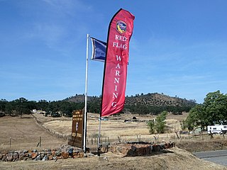
A red flag warning is a forecast warning issued by the National Weather Service (NWS) in the United States to inform the public, firefighters, and land management agencies that conditions are ideal for wildfire combustion, and rapid spread. These include drought conditions or a dry season, very low humidity, high or erratic winds, and the possibility of lightning. Firefighting agencies often respond to such a warning by altering their staffing and equipment resources dramatically. To the public, the warning means high fire danger with increased probability of a quickly spreading vegetation fire in the area within 24 hours.

The quantitative precipitation forecast is the expected amount of melted precipitation accumulated over a specified time period over a specified area. A QPF will be created when precipitation amounts reaching a minimum threshold are expected during the forecast's valid period. Valid periods of precipitation forecasts are normally synoptic hours such as 00:00, 06:00, 12:00 and 18:00 GMT. Terrain is considered in QPFs by use of topography or based upon climatological precipitation patterns from observations with fine detail. Starting in the mid-to-late 1990s, QPFs were used within hydrologic forecast models to simulate impact to rivers throughout the United States. Forecast models show significant sensitivity to humidity levels within the planetary boundary layer, or in the lowest levels of the atmosphere, which decreases with height. QPF can be generated on a quantitative, forecasting amounts, or a qualitative, forecasting the probability of a specific amount, basis. Radar imagery forecasting techniques show higher skill than model forecasts within 6 to 7 hours of the time of the radar image. The forecasts can be verified through use of rain gauge measurements, weather radar estimates, or a combination of both. Various skill scores can be determined to measure the value of the rainfall forecast.

Convective storm detection is the meteorological observation, and short-term prediction, of deep moist convection (DMC). DMC describes atmospheric conditions producing single or clusters of large vertical extension clouds ranging from cumulus congestus to cumulonimbus, the latter producing thunderstorms associated with lightning and thunder. Those two types of clouds can produce severe weather at the surface and aloft.

Airport weather stations are automated sensor suites which are designed to serve aviation and meteorological operations, weather forecasting and climatology. Automated airport weather stations have become part of the backbone of weather observing in the United States and Canada and are becoming increasingly more prevalent worldwide due to their efficiency and cost-savings.
Surface weather observations are the fundamental data used for safety as well as climatological reasons to forecast weather and issue warnings worldwide. They can be taken manually, by a weather observer, by computer through the use of automated weather stations, or in a hybrid scheme using weather observers to augment the otherwise automated weather station. The ICAO defines the International Standard Atmosphere (ISA), which is the model of the standard variation of pressure, temperature, density, and viscosity with altitude in the Earth's atmosphere, and is used to reduce a station pressure to sea level pressure. Airport observations can be transmitted worldwide through the use of the METAR observing code. Personal weather stations taking automated observations can transmit their data to the United States mesonet through the Citizen Weather Observer Program (CWOP), the UK Met Office through their Weather Observations Website (WOW), or internationally through the Weather Underground Internet site. A thirty-year average of a location's weather observations is traditionally used to determine the station's climate. In the US a network of Cooperative Observers make a daily record of summary weather and sometimes water level information.
Montreal is the second largest city in Canada and the largest city in the province of Quebec, located along the Saint Lawrence River at its junction with the Ottawa River. The city is geographically constrained, with the majority on the Island of Montreal in the Hochelaga Archipelago, and has several prominent features, including the eponymous Mount Royal. The region experiences four distinct seasons and is classified as a humid continental climate, with very cold and snowy winters and warm and humid summers.

Rain is a form of precipitation where water droplets that have condensed from atmospheric water vapor fall under gravity. Rain is a major component of the water cycle and is responsible for depositing most of the fresh water on the Earth. It provides water for hydroelectric power plants, crop irrigation, and suitable conditions for many types of ecosystems.
A weather warning generally refers to an alert issued by a meteorological agency to warn citizens of approaching dangerous weather. A weather watch, on the other hand, typically refers to an alert issued to indicate that conditions are favorable for the development of dangerous weather patterns, although the dangerous weather conditions themselves are not currently present.
Ife South is a Local Government Area in Osun State, Nigeria. Its headquarters are in the town of Ifetedo at 7°11′00″N4°42′00″E.
Wet bias is the phenomenon whereby some weather forecasters report an overestimated and exaggerated probability of precipitation to increase the usefulness and actionability of their forecast. The Weather Channel has been empirically shown, and has also admitted, to having a wet bias in the case of low probability of precipitation but not at high probabilities of precipitation. Some local television stations have been shown as having significantly greater wet bias, often reporting a 100% probability of precipitation in cases where it rains only 70% of the time.

Preceded by more than a week of heavy rain, a slow-moving storm system dropped tremendous precipitation across much of Texas and Oklahoma during the nights of May 24–26, 2015, triggering record-breaking floods. Additionally, many areas reported tornado activity and lightning. Particularly hard hit were areas along the Blanco River in Hays County, Texas, where entire blocks of homes were leveled. On the morning of May 26, the National Weather Service issued a flash flood emergency for southwest Harris County and northeast Fort Bend County. The system also produced deadly tornadoes in parts of Mexico, Texas, and Oklahoma. This flood significantly contributed to the wettest month ever for Texas and Oklahoma.
References
- ↑ Enyedi, Angie (27 August 2010). "What are PoPs?". National Weather Service, Jacksonville, FL. Archived from the original on 10 June 2015. Retrieved 27 November 2018.
- ↑ "What does a 30% chance of rain mean?". 23 May 2024.
- ↑ Gorski, Chris (21 August 2014). "How Do Daily Weather Forecasts Relate To Hourly Forecasts? It Depends". Inside Science. Retrieved 4 December 2018.
- ↑ National Weather Service. "Get your hourly weather forecast from the NWS". Weather.gov. Retrieved 4 December 2018.
- ↑ Bialik, Carl (2008-12-09). "Deciphering a 20% Chance of Rain". The Wall Street Journal.
- ↑ Silver, Nate (2012-09-07). "The Weatherman Is Not a Moron". The New York Times.
- ↑ "Weather and Meteorology - Glossary: Chance of Precipitation (COP)". Environment Canada. Retrieved 2015-06-07.
- ↑ "Guide to Environment Canada's Public Forecasts: Chance of Precipitation". Environment Canada. Retrieved 2015-06-07.
- ↑ "The science of 'probability of precipitation'". Met Office. 2014-08-14. Archived from the original on 2018-10-16.
- ↑ "Forecast Terms". National Weather Service, Binghamton, NY Weather Forecast Office. Retrieved 2015-06-07.
- ↑ The NWS alone has published other sets of terms, such as those in NOAA Technical Memorandum NWS AR-44 and NWS Instruction 10-503 (p. 18).
- ↑ "Chance of a shower? You decide, as Met Office launches new style weather forecasts". The Telegraph. 2011-11-10.
- ↑ Joslyn, Susan; Nadav-Greenberg, Limor; Nichols, Rebecca M. (February 2009). "Probability of Precipitation: Assessment and Enhancement of End-User Understanding". Bulletin of the American Meteorological Society. 90 (2): 185–193. Bibcode:2009BAMS...90..185J. doi: 10.1175/2008BAMS2509.1 .
- ↑ "2011 Golden Bull Awards". Plain English Campaign. Retrieved 2015-06-07.
- ↑ "Plain English award for Met Office 'gobbledygook'". BBC News. 2011-12-09. Retrieved 2015-06-07.
- ↑ "A golden conundrum". Met Office. 2011-12-09.
| Authority control databases: National |
|---|