Related Research Articles

The San Francisco–Oakland Bay Bridge, commonly referred to as the Bay Bridge, is a complex of bridges spanning San Francisco Bay in California. As part of Interstate 80 and the direct road between San Francisco and Oakland, it carries about 260,000 vehicles a day on its two decks. It includes one of the longest bridge spans in the United States.

Interstate 880 (I-880) is a north–south auxiliary Interstate Highway in the San Francisco Bay Area of Northern California. It runs from I-280 and State Route 17 (SR 17) in San Jose to I-80 and I-580 in Oakland, running parallel to the eastern shore of San Francisco Bay. For most of its route, I-880 is officially known as the Nimitz Freeway, after World War II fleet admiral Chester W. Nimitz, who retired to the Bay Area. The northernmost five miles (8.0 km) is also commonly referred to as the Cypress Freeway, after the former alignment of the freeway and its subsequent replacement.
Interstate 580 (I-580) is an approximately 76-mile-long (122 km) east–west auxiliary Interstate Highway in Northern California. The heavily traveled spur route of I-80 runs from US Route 101 (US 101) in San Rafael in the San Francisco Bay Area to I-5 at a point outside the southern city limits of Tracy in the Central Valley. I-580 forms a concurrency with I-80 between Albany and Oakland, the latter of which is the location of the MacArthur Maze interchange immediately east of the San Francisco–Oakland Bay Bridge. I-580 provides a connection from the Bay Area to the southern San Joaquin Valley and Southern California via I-5, as I-5 bypasses the Bay Area to the east.

Interstate 280 (I-280) is a 57.22-mile-long (92.09 km) major north–south auxiliary Interstate Highway in the San Francisco Bay Area of Northern California. It runs from I-680 and US Route 101 (US 101) in San Jose to King and 5th streets in San Francisco, running just to the west of the larger cities of San Francisco Peninsula for most of its route.
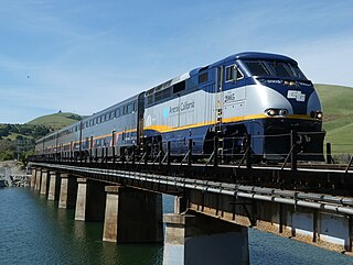
The Capitol Corridor is a 168-mile (270 km) passenger train route in Northern California operated by Amtrak between San Jose, in the Bay Area, and Auburn, in the Sacramento Valley. The route is named after the two points most trains operate between, San Jose and Sacramento. The route runs roughly parallel to I-880 and I-80. Some limited trips run between Oakland and San Jose. A single daily round trip runs between San Jose and Auburn, in the foothills of the Sierra Nevada. Capitol Corridor trains started in 1991.

The San Joaquins is a passenger train service operated by Amtrak in California's San Joaquin Valley. Seven daily round trips run between its southern terminus at Bakersfield and Stockton, with onward service to Sacramento and Oakland. For Fiscal year 2025, two additional trips to Sacramento will be added.
State Route 24 is a heavily traveled east–west state highway in the U.S. state of California that serves the eastern side of the San Francisco Bay Area. A freeway throughout its entire length, it runs from the Interstate 580/Interstate 980 interchange in Oakland, and through the Caldecott Tunnel under the Berkeley Hills, to the Interstate 680 junction in Walnut Creek. It lies in Alameda County, where it is highly urban, and Contra Costa County, where it passes through wooded hillsides and suburbs. SR 24 is a major connection between the San Francisco–Oakland Bay Bridge/MacArthur Maze complex and the inland cities of the East Bay.
State Route 160 is a state highway in the U.S. state of California consisting of two sections. The longer, southern, section is a scenic highway through the alluvial plain of the Sacramento River, linking SR 4 in Antioch with Sacramento via the Antioch Bridge. The northern section, separated from the southern by Sacramento city streets, is the North Sacramento Freeway, running from the 16th Street Bridge over the American River to Interstate 80 Business towards Roseville.
State Route 123 is a 7.39-mile (11.89 km) state highway in the U.S. state of California in the San Francisco Bay Area. Named San Pablo Avenue for almost its entire length except for its northernmost 0.10 miles (0.16 km), SR 123 is a major north–south state highway along the flats of the urban East Bay. Route 123 runs between Interstate 580 in Oakland in the south and Interstate 80 at Cutting Boulevard in Richmond in the north. San Pablo Avenue itself, a portion of Historic US 40, continues well past the SR 123 designation south to Downtown Oakland and north to Crockett.

The Central Freeway is a roughly one-mile (1.5 km) elevated freeway in San Francisco, California, United States, connecting the Bayshore/James Lick Freeway with the Hayes Valley neighborhood. Most of the freeway is part of US 101, which exits at Mission Street on the way to the Golden Gate Bridge. The freeway once extended north to Turk Street, and initially formed part of a loop around downtown, but was damaged along with the Embarcadero in the 1989 Loma Prieta earthquake; both highways have since been replaced with the surface-level Octavia Boulevard and Embarcadero, respectively.

The Carquinez Bridge is a pair of parallel bridges spanning the Carquinez Strait at the northeastern end of San Francisco Bay. They form the part of Interstate 80 between Crockett and Vallejo, California, United States.

The MacArthur Maze is a large freeway interchange in Oakland, California. It splits traffic coming off the east end of the San Francisco–Oakland Bay Bridge into three freeways: the Eastshore (I-80/I-580), MacArthur (I-580) and Nimitz (I-880).

The eastern span replacement of the San Francisco–Oakland Bay Bridge was a construction project to replace a seismically unsound portion of the Bay Bridge with a new self-anchored suspension bridge (SAS) and a pair of viaducts. The bridge is in the U.S. state of California and crosses the San Francisco Bay between Yerba Buena Island and Oakland. The span replacement took place between 2002 and 2013, and is the most expensive public works project in California history, with a final price tag of $6.5 billion, a 2,500% increase from the original estimate of $250 million, which was an initial estimate for a seismic retrofit of the span, not the full span replacement ultimately completed. Originally scheduled to open in 2007, several problems delayed the opening until September 2, 2013. With a width of 258.33 ft (78.74 m), comprising 10 general-purpose lanes, it is the world's widest bridge according to Guinness World Records.

State Route 17 is a state highway in the U.S. state of California that runs from State Route 1 in Santa Cruz to I-280 and I-880 in San Jose. SR 17, a freeway and expressway, carries substantial commuter and vacation traffic through the Santa Cruz Mountains at Patchen Pass between Santa Cruz and the San Francisco Bay Area.
Interstate 80 (I-80) is a transcontinental Interstate Highway in the United States, stretching from San Francisco, California, to Teaneck, New Jersey. The segment of I-80 in California runs east from San Francisco across the San Francisco–Oakland Bay Bridge to Oakland, where it turns north and crosses the Carquinez Bridge before turning back northeast through the Sacramento Valley. I-80 then traverses the Sierra Nevada, cresting at Donner Summit, before crossing into the state of Nevada within the Truckee River Canyon. The speed limit is at most 65 mph (105 km/h) along the entire route instead of the state's maximum of 70 mph (110 km/h) as most of the route is in either urban areas or mountainous terrain. I-80 has portions designated as the Eastshore Freeway and Alan S. Hart Freeway.

California's transportation system is complex and dynamic. Although known for its car culture and extensive network of freeways and roads, the state also has a vast array of rail, sea, and air transport. Several subway, light rail, and commuter rail networks are found in many of the state's largest population centers. In addition, with the state's location on the West Coast of the United States, several important ports in California handle freight shipments from the Pacific Rim and beyond. A number of airports are also spread out across the state, ranging from small general aviation airports to large international hubs like Los Angeles International Airport and San Francisco International Airport.

C.C. Myers, Inc. was a Rancho Cordova, California based construction company specializing in building highways and bridges. Started in 1977 by Clinton C. Myers, the company re-formed as an Employee Owned Venture in 2008, or ESOP company. The company filed for Chapter 7 bankruptcy and turned its assets over to the court to be distributed to creditors in 2016.
James E. Roberts was a noted American civil engineer. He was recognized with industry and government awards for his leadership in bridge engineering, especially in the area of seismic retrofit. He was the state bridge engineer at Caltrans during the Loma Prieta earthquake and Northridge earthquake. His public service career lasted more than 50 years in the US Army, US Army Reserves and Caltrans. Roberts career spanned over 50 years and covered some of the most active years for engineering experienced in California from the design and construction heyday of the 1950s and 1960s to his leadership during the reconstruction efforts and seismic retrofitting programs created after two significant California earthquakes the 1989 Loma Prieta earthquake and the 1994 Northridge earthquake.

The Yerba Buena Tunnel, also known as the Yerba Buena Island Tunnel, is a highway tunnel in San Francisco, California. It is the part of San Francisco–Oakland Bay Bridge complex that crosses Yerba Buena Island. The Yerba Buena Tunnel carries ten lanes of Interstate 80 (I-80) on two decks, connecting the two component spans of the Bay Bridge, the western suspension span and the eastern self-anchored suspension span. At the opening of the Bay Bridge in 1936, it was the world's largest-bore tunnel.

The San Mateo–Hayward Bridge is a bridge crossing the American state of California's San Francisco Bay, linking the San Francisco Peninsula with the East Bay. The bridge's western end is in Foster City, a suburb on the eastern edge of San Mateo. The eastern end of the bridge is in Hayward. It is the longest fixed-link bridge in California and the 25th longest in the world by length. The bridge is owned by the state of California, and is maintained by California Department of Transportation (Caltrans), the state highway agency. Further oversight is provided by the Bay Area Toll Authority (BATA).
References
- ↑ Ashton, Adam (12 September 2018). "California state engineers say yes to 8.5 percent raise, other perks". Sacramento Bee. Retrieved 9 December 2018.
- ↑ CA Dept. of Personnel Administration, Bargaining Process , 2007-07-17.
- ↑ Public Employment Relations Board, " Laws Archived 2011-11-18 at the Wayback Machine ," PERB: Public Employment Relations Board, Retrieved 2011-10-26.
- ↑ Ronald Yank, Bargaining Unit Contracts - Bargaining Unit 9, (PECG) - Professional Engineers Archived 2011-12-20 at the Wayback Machine , Calif. Dept. of Personnel Administration, July 2, 2003 to July 2, 2008.
- ↑ Sacramento Bee, Engineers' Union Takes Labor Savings Ideas to Legislature, 2011-03-09.
- ↑ KCRA.com, Good Start to Cell Phone Turn In? Archived 2012-04-03 at the Wayback Machine , 2011-06-08.
- ↑ Los Angeles Times, Unions Sue to Halt Furloughs, 2008-12-23.
- ↑ CNN.com, California Supreme Court Upholds Furlough Order for State Workers, 2010-10-04.
- ↑ San Francisco Chronicle, SF's Doyle Drive Deal Blocked by Court, 2010-12-23.
- ↑ CBS Sacramento, On the Money: Cutting Out Caltrans, 2011-03-07.