Gmina Korczyna is a rural gmina in Krosno County, Subcarpathian Voivodeship, in south-eastern Poland. Its seat is the village of Korczyna, which lies approximately 7 kilometres (4 mi) north-east of Krosno and 38 km (24 mi) south of the regional capital Rzeszów.

Draganowa is a village in the administrative district of Gmina Chorkówka, within Krosno County, Subcarpathian Voivodeship, in south-eastern Poland. It lies approximately 7 kilometres (4 mi) south-west of Chorkówka, 13 km (8 mi) south-west of Krosno, and 56 km (35 mi) south-west of the regional capital Rzeszów.
Faliszówka is a village in the administrative district of Gmina Chorkówka, within Krosno County, Subcarpathian Voivodeship, in south-eastern Poland. It lies approximately 7 kilometres (4 mi) west of Chorkówka, 13 km (8 mi) south-west of Krosno, and 54 km (34 mi) south-west of the regional capital Rzeszów.
Kobylany is a village in the administrative district of Gmina Chorkówka, within Krosno County, Subcarpathian Voivodeship, in south-eastern Poland. It lies approximately 6 kilometres (4 mi) south-west of Chorkówka, 12 km (7 mi) south-west of Krosno, and 54 km (34 mi) south-west of the regional capital Rzeszów. The village has a population of 1,100.
Leśniówka is a village in the administrative district of Gmina Chorkówka, within Krosno County, Subcarpathian Voivodeship, in south-eastern Poland. It lies approximately 5 kilometres (3 mi) north-west of Chorkówka, 9 km (6 mi) west of Krosno, and 49 km (30 mi) south-west of the regional capital Rzeszów.

Chyrowa is a village in the administrative district of Gmina Dukla, within Krosno County, Subcarpathian Voivodeship, in south-eastern Poland, close to the border with Slovakia. It lies approximately 6 kilometres (4 mi) south-west of Dukla, 19 km (12 mi) south-west of Krosno, and 62 km (39 mi) south-west of the regional capital Rzeszów.
Mszana is a village in the administrative district of Gmina Dukla, within Krosno County, Subcarpathian Voivodeship, in south-eastern Poland, close to the border with Slovakia. It lies approximately 9 kilometres (6 mi) south of Dukla, 23 km (14 mi) south of Krosno, and 66 km (41 mi) south-west of the regional capital Rzeszów.
Ropianka is a village in the administrative district of Gmina Dukla, within Krosno County, Subcarpathian Voivodeship, in south-eastern Poland, close to the border with Slovakia. It lies approximately 10 kilometres (6 mi) south of Dukla, 24 km (15 mi) south of Krosno, and 67 km (42 mi) south-west of the regional capital Rzeszów.
Teodorówka is a village in the administrative district of Gmina Dukla, within Krosno County, Subcarpathian Voivodeship, in south-eastern Poland, close to the border with Slovakia. It lies approximately 3 kilometres (2 mi) south-west of Dukla, 17 km (11 mi) south-west of Krosno, and 60 km (37 mi) south-west of the regional capital Rzeszów.
Dobieszyn is a village in the administrative district of Gmina Jedlicze, within Krosno County, Subcarpathian Voivodeship, in south-eastern Poland. It lies approximately 4 kilometres (2 mi) south-east of Jedlicze, 5 km (3 mi) west of Krosno, and 45 km (28 mi) south-west of the regional capital Rzeszów.
Bajdy is a village in the administrative district of Gmina Wojaszówka, within Krosno County, Subcarpathian Voivodeship, in south-eastern Poland. It lies approximately 3 kilometres (2 mi) south-west of Wojaszówka, 12 km (7 mi) north-west of Krosno, and 39 km (24 mi) south-west of the regional capital Rzeszów.
Bratkówka is a village in the administrative district of Gmina Wojaszówka, within Krosno County, Subcarpathian Voivodeship, in south-eastern Poland. It lies approximately 4 kilometres (2 mi) south-east of Wojaszówka, 10 km (6 mi) north of Krosno, and 37 km (23 mi) south-west of the regional capital Rzeszów.
Łączki Jagiellońskie is a village in the administrative district of Gmina Wojaszówka, within Krosno County, Subcarpathian Voivodeship, in south-eastern Poland. It lies approximately 3 kilometres (2 mi) north-east of Wojaszówka, 14 km (9 mi) north of Krosno, and 34 km (21 mi) south-west of the regional capital Rzeszów.
Odrzykoń is a village in the administrative district of Gmina Wojaszówka, within Krosno County, Subcarpathian Voivodeship, in south-eastern Poland. It lies approximately 7 kilometres (4 mi) south-east of Wojaszówka, 8 km (5 mi) north of Krosno, and 37 km (23 mi) south-west of the regional capital Rzeszów.
Pietrusza Wola is a village in the administrative district of Gmina Wojaszówka, within Krosno County, Subcarpathian Voivodeship, in south-eastern Poland. It lies approximately 4 kilometres (2 mi) north of Wojaszówka, 16 km (10 mi) north of Krosno, and 34 km (21 mi) south-west of the regional capital Rzeszów. Its approximate population is 300.
Rzepnik is a village in the administrative district of Gmina Wojaszówka, within Krosno County, Subcarpathian Voivodeship, in south-eastern Poland. It lies approximately 6 kilometres (4 mi) east of Wojaszówka, 13 km (8 mi) north of Krosno, and 32 km (20 mi) south-west of the regional capital Rzeszów.
Ustrobna is a village in the administrative district of Gmina Wojaszówka, within Krosno County, Subcarpathian Voivodeship, in south-eastern Poland. It lies approximately 4 kilometres (2 mi) south of Wojaszówka, 9 km (6 mi) north-west of Krosno, and 39 km (24 mi) south-west of the regional capital Rzeszów.
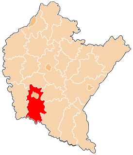
Wojaszówka is a village in Krosno County, Subcarpathian Voivodeship, in south-eastern Poland. It is the seat of the gmina called Gmina Wojaszówka. It lies approximately 13 kilometres (8 mi) north-west of Krosno and 37 km (23 mi) south-west of the regional capital Rzeszów.
Wojkówka is a village in the administrative district of Gmina Wojaszówka, within Krosno County, Subcarpathian Voivodeship, in south-eastern Poland. It lies approximately 2 kilometres (1 mi) east of Wojaszówka, 12 km (7 mi) north of Krosno, and 36 km (22 mi) south-west of the regional capital Rzeszów.