Gmina Brzesko is an urban-rural gmina in Brzesko County, Lesser Poland Voivodeship, in southern Poland. Its seat is the town of Brzesko, which lies approximately 50 kilometres (31 mi) east of the regional capital Kraków.
Gmina Dębno is a rural gmina in Brzesko County, Lesser Poland Voivodeship, in southern Poland. Its seat is the village of Dębno, which lies approximately 8 kilometres (5 mi) east of Brzesko and 57 km (35 mi) east of the regional capital Kraków.
Gmina Szczurowa is a rural gmina in Brzesko County, Lesser Poland Voivodeship, in southern Poland. Its seat is the village of Szczurowa, which lies approximately 17 kilometres (11 mi) north of Brzesko and 52 km (32 mi) east of the regional capital Kraków.

Wokowice is a village in the administrative district of Gmina Brzesko, within Brzesko County, Lesser Poland Voivodeship, in southern Poland. It lies approximately 8 kilometres (5 mi) north-east of Brzesko and 55 km (34 mi) east of the regional capital Kraków.
Bielcza is a village in the administrative district of Gmina Borzęcin, within Brzesko County, Lesser Poland Voivodeship, in southern Poland. It lies approximately 7 kilometres (4 mi) south of Borzęcin, 10 km (6 mi) north-east of Brzesko, and 56 km (35 mi) east of the regional capital Kraków.
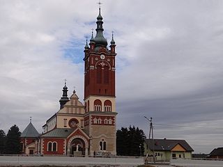
Borzęcin is a village in Brzesko County, Lesser Poland Voivodeship, in southern Poland. It is the seat of the gmina called Gmina Borzęcin. It lies approximately 14 kilometres (9 mi) north-east of Brzesko and 55 km (34 mi) east of the regional capital Kraków. It is located on the Uszwica river and divided into two sołectwos, Upper Borzęcin and Lower Borzęcin. Currently it has a population of about 3,700 inhabitants.
Jagniówka is a village in the administrative district of Gmina Borzęcin, within Brzesko County, Lesser Poland Voivodeship, in southern Poland. It lies approximately 5 kilometres (3 mi) north of Borzęcin, 19 km (12 mi) north of Brzesko, and 56 km (35 mi) east of the regional capital Kraków.
Łęki is a village in the administrative district of Gmina Borzęcin, within Brzesko County, Lesser Poland Voivodeship, in southern Poland. It lies approximately 8 kilometres (5 mi) south-west of Borzęcin, 7 km (4 mi) north-east of Brzesko, and 53 km (33 mi) east of the regional capital Kraków.
Waryś is a village in the administrative district of Gmina Borzęcin, within Brzesko County, Lesser Poland Voivodeship, in southern Poland. It lies approximately 5 kilometres (3 mi) south-east of Borzęcin, 14 km (9 mi) north-east of Brzesko, and 59 km (37 mi) east of the regional capital Kraków.
Dołęga is a village in the administrative district of Gmina Szczurowa, within Brzesko County, Lesser Poland Voivodeship, in southern Poland. It lies approximately 5 kilometres (3 mi) south-east of Szczurowa, 16 km (10 mi) north of Brzesko, and 55 km (34 mi) east of the regional capital Kraków.
Kwików is a village in the administrative district of Gmina Szczurowa, within Brzesko County, Lesser Poland Voivodeship, in southern Poland. It lies approximately 2 kilometres (1 mi) north of Szczurowa, 19 km (12 mi) north of Brzesko, and 52 km (32 mi) east of the regional capital Kraków.
Rajsko is a village in the administrative district of Gmina Szczurowa, within Brzesko County, Lesser Poland Voivodeship, in southern Poland. It lies approximately 4 kilometres (2 mi) west of Szczurowa, 16 km (10 mi) north of Brzesko, and 48 km (30 mi) east of the regional capital Kraków.
Szczurowa is a village in Brzesko County, Lesser Poland Voivodeship, in southern Poland. It is the seat of the gmina called Gmina Szczurowa. It lies approximately 17 kilometres (11 mi) north of Brzesko and 52 km (32 mi) east of the regional capital Kraków.
Zaborów is a village in the administrative district of Gmina Szczurowa, within Brzesko County, Lesser Poland Voivodeship, in southern Poland. It lies approximately 4 kilometres (2 mi) north-east of Szczurowa, 20 km (12 mi) north of Brzesko, and 54 km (34 mi) east of the regional capital Kraków.
Grębocin is a village in the administrative district of Gmina Nowe Brzesko, within Proszowice County, Lesser Poland Voivodeship, in southern Poland. It lies approximately 5 kilometres (3 mi) north-west of Nowe Brzesko, 6 km (4 mi) south-east of Proszowice, and 32 km (20 mi) east of the regional capital Kraków.
Szpitary is a village in the administrative district of Gmina Nowe Brzesko, within Proszowice County, Lesser Poland Voivodeship, in southern Poland. It lies approximately 2 kilometres (1 mi) north-west of Nowe Brzesko, 8 km (5 mi) south-east of Proszowice, and 33 km (21 mi) east of the regional capital Kraków.
Ułanowice is a village in the administrative district of Gmina Klimontów, within Sandomierz County, Świętokrzyskie Voivodeship, in south-central Poland. It lies approximately 6 kilometres (4 mi) west of Klimontów, 27 km (17 mi) west of Sandomierz, and 59 km (37 mi) south-east of the regional capital Kielce.
Kruszyna is a village in the administrative district of Gmina Zaklików, within Stalowa Wola County, Subcarpathian Voivodeship, in south-eastern Poland. It lies approximately 12 kilometres (7 mi) south of Zaklików, 11 km (7 mi) north-east of Stalowa Wola, and 71 km (44 mi) north of the regional capital Rzeszów.
Kalinowo is a village in the administrative district of Gmina Giżycko, within Giżycko County, Warmian-Masurian Voivodeship, in northern Poland. It lies approximately 7 kilometres (4 mi) west of Giżycko and 81 km (50 mi) east of the regional capital Olsztyn.


