History
When the Siegfried Line (in German the Westwall) was built in 1939, a standby bunker was constructed for the Wehrmacht inside the Kalvarienberg. The underground bunker was located 20 to 30 metres below the top of the hill and consisted of a 100-metre-long and a 60-metre-long tunnel. After the Second World War, French troops dumped 500 tons of ammunition there, which was supposed to be used to blow up the fortifications of the Siegfried Line. The population of Prüm knew about this storage and was concerned about it.
On 15 July 1949, there was a fire in the bunker. Prüm's Volunteer Fire Service sounded a fire alarm shortly before 7.00 pm and tried to put out the fire, but was unable to get into the deep galleries to reach the source of the fire. There was time to successfully extract them and to evacuate large parts of the population of Prüm, actions which saved many lives. The ammunition dump blew up around 8.22 pm. In the process, 250,000 m³ of rock, earth and bunker debris were thrown into the air, falling on Prüm. Twelve people were killed, 15 were injured and 965 people were left homeless. The water supply collapsed, telephone lines and some roads were completely destroyed. The hospital, school and post office, as well as numerous residential buildings were left in ruins. The explosion crater measured 190 × 90 metres and was over 20 metres deep. The explosion was even registered by earthquake observatories.
This was the second time in short succession that Prüm had been devastated. During the war, 92 percent of the town had been destroyed by air raids and ground fighting. As Prüm was not completely rebuilt until 1949, 900 of its former inhabitants still lived outside the town.
After the explosion, the Luxembourg army from the garrison in Bitburg and the French army with its medical services gave assistance to the town. The fire brigades, teams from the German Red Cross from across the Eifel and the fire services of Koblenz and Neuwied were also involved in the rescue operation. Minister-President Peter Altmeier and Minister Johann Junglas hurried to the disaster area at night. There was much sympathy in the country and so the town was able to be rebuilt with the aid of donations.
The cause of the accident, which devastated Prüm and the surrounding area, was never ascertained. The suspicion that it was an act of sabotage was still held by some of the population even 60 years later. At the end of the 1990s, the Minister of Defence, Rudolf Scharping and the French National Archives, worked jointly to try and find an explanation but without success.
In 1979, a seven-metre-high commemorative cross, made of basalt and created by artist, Johann Baptist Lenz from Oberkail, was erected on the Kalvarienberg in remembrance of the explosion.

The Eifel is a low mountain range in western Germany, eastern Belgium and northern Luxembourg. It occupies parts of southwestern North Rhine-Westphalia, northwestern Rhineland-Palatinate and the southern area of the German-speaking Community of Belgium.
Vulkaneifel is a district (Kreis) in the northwest of the state Rhineland-Palatinate, Germany. It is the least densely populated district in the state and the fourth most sparsely populated district in Germany. The administrative centre of the district is in Daun. Neighboring districts are Euskirchen, Ahrweiler, Mayen-Koblenz, Cochem-Zell, Bernkastel-Wittlich, and Bitburg-Prüm.
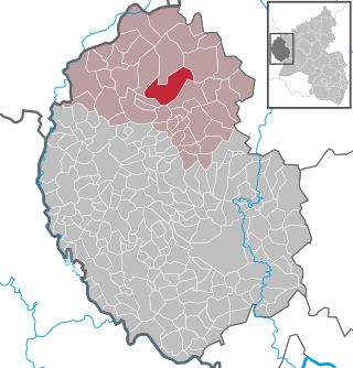
Prüm is a town in the Westeifel (Rhineland-Palatinate), Germany. Formerly a district capital, today it is the administrative seat of the Verbandsgemeinde Prüm.

Mayen is a town in the Mayen-Koblenz District of the Rhineland-Palatinate Federal State of Germany, in the eastern part of the Volcanic Eifel Region. As well as the main town, additional settlements include Alzheim, Kürrenberg, Hausen-Betzing, Hausen and Nitztal. Mayen is the administrative centre of the Vordereifel ‘Collective Municipality’, although it is not part of the municipality.

Andernach is a town in the district of Mayen-Koblenz, in Rhineland-Palatinate, Germany, of about 30,000 inhabitants. It is situated towards the end of the Neuwied basin on the left bank of the Rhine between the former tiny fishing village of Fornich in the north and the mouth of the small river Nette in the southeast, just 13 miles (21 km) north of Koblenz, with its five external town districts: Kell, Miesenheim, Eich, Namedy, and Bad Tönisstein.
There have been many extremely large explosions, accidental and intentional, caused by modern high explosives, boiling liquid expanding vapour explosions (BLEVEs), older explosives such as gunpowder, volatile petroleum-based fuels such as gasoline, and other chemical reactions. This list contains the largest known examples, sorted by date. An unambiguous ranking in order of severity is not possible; a 1994 study by historian Jay White of 130 large explosions suggested that they need to be ranked by an overall effect of power, quantity, radius, loss of life and property destruction, but concluded that such rankings are difficult to assess.

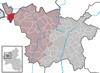
Waxweiler is a municipality in the county of Bitburg-Prüm, in Rhineland-Palatinate, western Germany. It is located in the Eifel, south of Prüm and is accessible through the Autobahn 60. The parish of about 1100 inhabitants lies 345 meters above sea level.
Ormont is an Ortsgemeinde situated in the Vulkaneifel district in Rhineland-Palatinate, Germany. It belongs to the Verbandsgemeinde of Gerolstein, whose seat is in the municipality of Gerolstein.

Salm is an Ortsgemeinde – a municipality belonging to a Verbandsgemeinde, a kind of collective municipality – in the Vulkaneifel district in Rhineland-Palatinate, Germany. It belongs to the Verbandsgemeinde of Gerolstein, whose seat is in the like-named town.

Stadtkyll is an Ortsgemeinde – a municipality belonging to a Verbandsgemeinde, a kind of collective municipality – in the Vulkaneifel district in Rhineland-Palatinate, Germany. It belongs to the Verbandsgemeinde of Gerolstein, whose seat is in the municipality of Gerolstein. Stadtkyll is a state-recognized climatic spa (Luftkurort).

An explosion crater is a type of crater formed when material is ejected from the surface of the ground by an explosion at or immediately above or below the surface.
The Schnee Eifel is a heavily wooded landscape in Germany's Central Uplands, up to 699.1 m above sea level (NHN), that forms part of the western Eifel in the area of the German-Belgian border. The name may have been derived in the 19th century from the Schneifel chain of hills, which had nothing to do with snow (Schnee), but with the name for a forest swathe (Schneise).

A calvary, also called calvary hill, Sacred Mount, or Sacred Mountain, is a type of Christian sacred place, built on the slopes of a hill, composed by a set of chapels, usually laid out in the form of a pilgrims' way. It is intended to represent the passion of Jesus Christ and takes its name after Calvary, the hill in Jerusalem where Jesus was crucified.

Bitburg-Erdorf station is a station on the Eifel Railway in Bitburg in the German state of Rhineland-Palatinate. The Nims–Sauer Valley railway (Nims-Sauertalbahn) branched off here to the now closed Bitburg Town station, the remaining part of which is only used for freight traffic and occasional excursion trains. Today Bitburg-Erdorf station is the only station in Bitburg that is served by regular passenger services.
The Eifel Literatur Festival is a volunteer-organized literature event held in the Eifel mountains in the German state of Rhineland-Palatinate every two years as part of the state's "Cultural Summer".
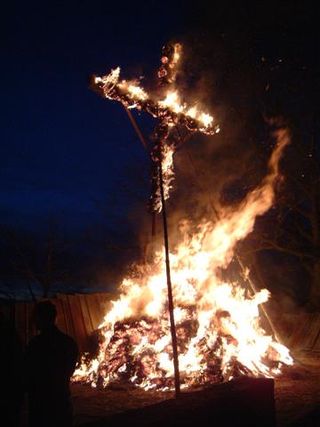
Hüttenbrennen, sometimes also referred to as Burgbrennen, is an old-fashioned bonfire custom in many part of the Eifel mountains in Germany. It is celebrated every year on "Straw Sunday", the first Sunday after Shrove Tuesday, also observed as Funkensonntag.

The Neuerburg is a castle and fortress in the western Eifel mountains in the Enzbach valley above the town of Neuerburg in the county of Eifelkreis Bitburg-Prüm in the German state of Rhineland-Palatinate. After being restored from 1926 onwards, it has been used as a Jugendburg.
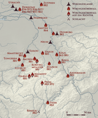
The Viking raids in the Rhineland were part of a series of invasions of Francia by the Vikings that took place during the final decades of the 9th century. From the Rhineland, which can be regarded as the nucleus of Frankish culture, the Franks had previously conquered almost the whole of Central Europe and established a great empire.

The Prümerburg is a ruined hill castle on a roughly 30-metre-high lias-sandstone rock on the upper edge of the valley of the Prüm in the municipality of Prümzurlay in the county of Bitburg-Prüm in the German state of Rhineland-Palatinate.


