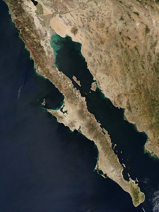
The Baja California peninsula is a peninsula in northwestern Mexico. It separates the Gulf of California from the Pacific Ocean. The peninsula extends from Mexicali, Baja California, in the north to Cabo San Lucas, Baja California Sur, in the south.

The Gulf of California, also known as the Sea of Cortés or Sea of Cortez, or less commonly as the Vermilion Sea, is a marginal sea of the Pacific Ocean that separates the Baja California Peninsula from the Mexican mainland. It is bordered by the states of Baja California, Baja California Sur, Sonora, and Sinaloa with a coastline of approximately 4,000 km (2,500 mi). Rivers that flow into the Gulf of California include the Colorado, Fuerte, Mayo, Sinaloa, Sonora, and the Yaqui. The surface of the gulf is about 160,000 km2 (62,000 sq mi). Maximum depths exceed 3,000 meters (9,800 ft) because of the complex geology, linked to plate tectonics.
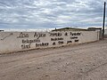
Bahía de los Ángeles is a coastal bay on the Gulf of California, located along the eastern shore of the Baja California Peninsula in the state of Baja California, Mexico. The town of the same name is located at the east end of Federal Highway 12 about 42 miles (68 km) from the Parador Punta Prieta junction on Federal Highway 1. The area is part of the San Quintín Municipality.

La Paz is the capital city of the Mexican state of Baja California Sur. The city had a 2020 census population of 250,141 inhabitants, making it the most populous city in the state. Its metropolitan population is somewhat larger because of the surrounding towns, such as El Centenario, Chametla and San Pedro. It is in La Paz Municipality, which is the fourth-largest municipality in Mexico in geographical size and reported a population of 292,241 inhabitants on a land area of 20,275 km2 (7,828 sq mi).

Puerto Peñasco is a small city located in Puerto Peñasco Municipality in the northwest of the Mexican state of Sonora, 100 kilometres (62 mi) from the border with the U.S. state of Arizona. According to the 2020 census, it has a population of 62,689 inhabitants. It is located on the northern shores of the Sea of Cortez on the small strip of land that joins the Baja California Peninsula with the rest of Mexico. The area is part of the Altar Desert, one of the driest and hottest areas of the larger Sonoran Desert.

Puerto Escondido is a small port and tourist center in the municipality of San Pedro Mixtepec Distrito 22 in the Mexican state of Oaxaca. Prior to the 1930s, there was no town. The bay had been used as a port intermittently to ship coffee, but there was no permanent settlement due to the lack of potable water. The name "Puerto Escondido" had roots in the legend of a woman who escaped her captors and hid here. The Nahuatl word for this area was Zicatela, meaning “place of large thorns". Today, it refers to the area's most famous beach.

Loreto is a city and municipal seat of Loreto Municipality, Baja California Sur, on the West Coast of Mexico. Located on the Gulf of California, the city had a population of 20,385 inhabitants in 2019. Loreto is a regional economic and cultural center, as well as a major tourist destination on the Baja California Peninsula.

Bahía de Banderas is a bay on the Pacific Coast of Mexico, within the Mexican states of Jalisco and Nayarit. It is also the name of an administrative municipality, located on the bay in Nayarit state. The port and resort city of Puerto Vallarta is on the bay.
Huatulco, formally Bahías de Huatulco, centered on the town of La Crucecita, is a tourist development in Mexico. It is located on the Pacific coast in the state of Oaxaca. Huatulco's tourism industry is centered on its nine bays, thus the name Bahias de Huatulco, but has since been unofficially shortened to simply Huatulco. Huatulco has a wide variety of accommodation from rooms for rent, small economy hotels, luxury villas, vacation condominia, bed and breakfasts, as well as several luxury resorts standing on or near the shores of Tangolunda Bay. The Camino Real Zaashila, Quinta Real Huatulco, Las Brisas, Dreams Resort & Spa, and the Barceló are examples of the most popular larger resorts in the area.

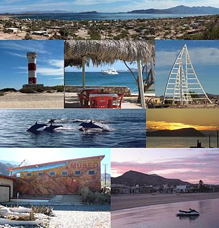
San Felipe is a coastal city in San Felipe Municipality, Baja California, located on the Gulf of California. The population of San Felipe was reported as 17,143 inhabitants in the 2020 Mexican Census. San Felipe is historically a fishing town. Today it is also a popular tourist destination, known for its beaches, nature, and desert racing, as home to the San Felipe 250.

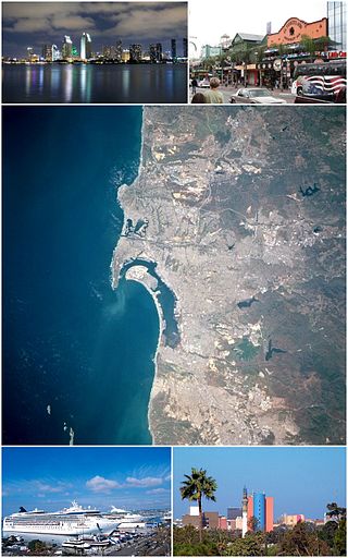
Mission Bay is a human-made saltwater bay located south of the Pacific Beach community of San Diego, California created from approximately 2,000 acres (810 ha) of historical wetland, marsh, and saltwater bay habitat. The bay is part of the recreational Mission Bay Park, the largest man-made aquatic park in the United States, consisting of 4,235 acres (17.14 km2), approximately 46% land and 54% water. The combined area makes Mission Bay Park the ninth largest municipally-owned park in the United States.

The San Antonio River is a major waterway that originates in central Texas in a cluster of springs in midtown San Antonio, about 4 miles north of downtown, and follows a roughly southeastern path through the state. It eventually feeds into the Guadalupe River about 10 miles from San Antonio Bay on the Gulf of Mexico. The river is 240 miles long and crosses five counties: Bexar, Goliad, Karnes, Refugio, and Wilson.

Bahía Kino is a town part of the Hermosillo Municipality in Sonora, Mexico on the Gulf of California; it was named after Eusebio Kino. It has a population of approximately 7,000 people. The name also applies to the adjacent bay between Tiburón Island and Punta San Nicolás, Sonora. The names Bahía de Kino, Bahía Kino and Kino Bay are used interchangeably.

Ocotillo Wells is an unincorporated community in San Diego County, California, United States. It is 3 miles (4.8 km) west of the Imperial County line on California State Route 78 at an elevation of 163 feet (50 m). The name became official in 1962 when it was adopted for federal use by the US Board on Geographic Names. A federally recognized variant name, Ocotillo, can cause confusion with the community of Ocotillo, California in Imperial County, 29 mi (47 km) to the south on Interstate 8.
The Colorados Archipelago is a chain of isles and cays on Cuba's north-western coast.
Federal Highway 5 is a tollfree part of the federal highways corridors, and follows the northeast length of the state of Baja California from the US-Mexico border in Mexicali at the northern point at San Felipe in the south. The highway is entirely inside the Mexicali Municipality. However, a state highway from San Felipe to Puertecitos is usually considered part of Fed. 5. From San Felipe to the south, the road follows the seacoast of the Gulf of California.

Slates Hot Springs is the site of a hot spring in the Big Sur region of Monterey County, California. It is located 8 miles (13 km) north-northwest of Lopez Point, at an elevation of 118 feet.

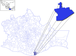
San Felipe is the newest municipality in the Mexican state of Baja California. Inaugurated on 1 January 2022, it is located approximately 190 kilometres (120 mi) south of Mexicali, the state capital.