Easthampton is a city in Hampshire County, Massachusetts, United States. The city is in the Pioneer Valley near the five colleges in the college towns of Northampton and Amherst. The population was 16,211 at the 2020 census.

The city of Northampton is the county seat of Hampshire County, Massachusetts, United States. As of the 2020 census, the population of Northampton was 29,571.

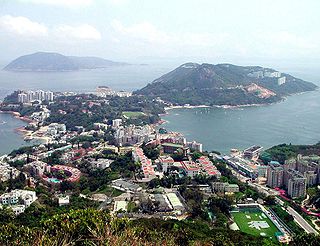
Stanley, or Chek Chue, is a coastal town and a popular tourist attraction in Hong Kong. It is located on a peninsula on Hong Kong Island. It is east of Repulse Bay and west of Shek O, adjacent to Chung Hom Kok and Tai Tam. Administratively, it is part of the Southern District.

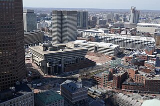
Government Center is an area in downtown Boston, centered on City Hall Plaza. Formerly the site of Scollay Square, it is now the location of Boston City Hall, courthouses, state and federal office buildings, and a major MBTA subway station, also called Government Center. Its development was controversial, as the project displaced thousands of residents and razed several hundred homes and businesses.

Western Massachusetts, known colloquially as "western Mass," is a region in Massachusetts, one of the six U.S. states that make up the New England region of the United States. Western Massachusetts has diverse topography; 22 colleges and universities including UMass in Amherst, MA, with approximately 100,000 students; and such institutions as Tanglewood, the Springfield Armory, and Jacob's Pillow.

Forest Park in Springfield, Massachusetts, is one of the largest urban, municipal parks in the United States, covering 735 acres (297 ha) of land overlooking the Connecticut River. Forest Park features a zoo, aquatic gardens, and outdoor amphitheater, in addition to design elements like winding wooded trails, and surprising, expansive views. The site of America's first public, municipal swimming pool, currently, during the holiday months Forest Park hosts a popular high-tech lighting display, known as Bright Nights. Contrary to popular belief, the park was not designed by Frederick Law Olmsted, although it was designed by his firm.

Wood Island station is a MBTA Blue Line rapid transit station located off Bennington Street in the Day Square section of East Boston, Boston, Massachusetts. The station is adjacent to and named for the former Wood Island Park, a once heavily used recreational area for East Boston residents. Most of the park was destroyed in the mid 1960s to expand Logan International Airport. It was built in 1952, replacing a pair of Boston, Revere Beach and Lynn Railroad stations that served the area.

The Mill River is a 13.5-mile-long (21.7 km) tributary of the Connecticut River arising in the western hilltowns of Hampshire County, Massachusetts. It is notable for dropping in elevation, along with its West Branch, more than 700 feet (210 m) over 15 miles (24 km).

The Auburn Mall, managed by Simon Property Group, which owns 56.1% of it, is an enclosed shopping mall located on Route 12 in Auburn, Massachusetts, United States, near the intersection of the Massachusetts Turnpike and I-290/I-395.
North Quincy is a neighborhood of Quincy, Massachusetts. It is separated from the city of Boston by the Neponset River, and borders the Quincy neighborhoods of Squantum, Montclair and Wollaston. It contains the smaller neighborhoods of Atlantic and Norfolk Downs, as well as much of Wollaston Beach.

The Hampden County Memorial Bridge is a reinforced-concrete arch bridge that spans the Connecticut River between Springfield, Massachusetts and West Springfield, Massachusetts, constructed in 1922. The bridge is owned by Massachusetts Highway Department and is located on Massachusetts Route 147. It spans 209 feet (64 m) and rises 29.71 feet (9.06 m) above the river.
Mondawmin Mall is a three-level shopping mall in West Baltimore, Maryland, United States. The mall was a development of the Mondawmin Corporation, a firm set up in 1952 by James Rouse and Hunter Moss under the Moss-Rouse Company. When it first opened in October 1956, it had an open-air plan and was called the Mondawmin Center. It was later enclosed and renamed the Mondawmin Mall.

The Oxbow, also known as the Ox-Bow, is an extension of the Connecticut River, located in Northampton, Massachusetts. It is well-known for its appearance in the 1836 painting The Oxbow by Thomas Cole.

City Hall Plaza in Boston, Massachusetts, is a large, open, public space in the Government Center area of the city. The architectural firm Kallmann McKinnell & Knowles designed the plaza in 1962 to accompany Boston's new City Hall building. The multi-level, irregularly shaped plaza consists of red brick and concrete. The Government Center MBTA station is located beneath the plaza; its entrance is at the southwest corner of the plaza.
Boston Road is Springfield, Massachusetts's principal commercial and retail corridor, located on the eastern edge of the city. The Boston Road neighborhood, historically known as Springfield Plain, is named for being a major waypoint on the Boston Post Road system.
This is a list of roundabouts in the state of Massachusetts in the United States. Intersections that are called traffic circles or roundabouts in the rest of the US are referred to as "rotaries" in Massachusetts, as well as other parts of New England including parts of Connecticut, New Hampshire, Maine Rhode Island, & Vermont.

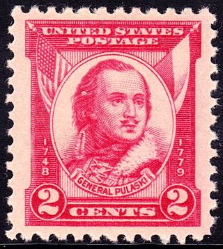
Casimir Pulaski was a Polish nobleman, soldier and military commander who has been called "the father of the American cavalry". He has had hundreds of monuments, memorial plaques, streets, parks and similar objects named after him.
Cambridge Discovery Park, formerly known as Acorn Park, is a 30 acres (12 ha) office and laboratory campus in Cambridge, Massachusetts. It is located along Massachusetts Route 2, and is connected to the Alewife Red Line subway terminus and bus station by a walking path, and to the Minuteman Bikeway.

Harvard University's Smith Campus Center is a Brutalist administrative and service building located at Harvard Square in Cambridge, Massachusetts, directly opposite the Wadsworth Gate to Harvard Yard. It houses Harvard administrative offices, an infirmary of the University Health Services, and a retail/restaurant arcade.


