Punch, United States Virgin Islands | |
|---|---|
Village | |
| Country | |
| Island | Saint Croix |
| Time zone | UTC-4 (AST) |
Punch is a settlement on the island of Saint Croix in the United States Virgin Islands.
Punch, United States Virgin Islands | |
|---|---|
Village | |
| Country | |
| Island | Saint Croix |
| Time zone | UTC-4 (AST) |
Punch is a settlement on the island of Saint Croix in the United States Virgin Islands.

The United States Virgin Islands are a group of several dozen islands and cays located in the Caribbean, about 1,100 miles (1,770 km) southeast of Florida, 600 miles (966 km) north of Venezuela, 40 miles (64 km) east of Puerto Rico, and immediately west and south of the British Virgin Islands.
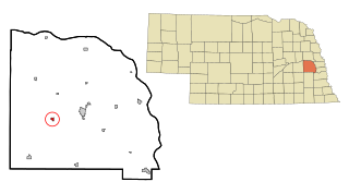
Weston is a village in Saunders County, Nebraska, United States. The population was 324 at the 2010 census.

Rome Township is a township in Bradford County, Pennsylvania, United States. The population was 1,191 at the 2010 census.

McMillan is a town in Marathon County, Wisconsin, United States. It is part of the Wausau, Wisconsin Metropolitan Statistical Area. The population was 1,968 at the 2010 census. The unincorporated community of McMillan is located in the town. A section of the Mead Wildlife Area is also located in the town.
Kingshill is a settlement on the island of Saint Croix in the United States Virgin Islands. Kingshill is home to the University of the Virgin Islands campus in St. Croix. The St. Croix campus opened in 1964.

Cruz Bay, U.S. Virgin Islands is the main town on the island of Saint John in the United States Virgin Islands. According to the 2000 census, Cruz Bay had a population of 2,743.
The area code (340) is the local telephone area code of U.S. Virgin Islands. The (340) area code was created during a split from the original (809) area code, which began permissive dialing on 1 June 1997 and ended 30 June 1998.

Wulfila Glacier is located on the southern slopes of Breznik Heights, Greenwich Island in the South Shetland Islands, Antarctica, south-southwest of Solis Glacier and west of Zheravna Glacier. It is bounded by Oborishte Ridge to the northwest, Nevlya Peak to the north, Terter Peak and Razgrad Peak to the northeast, and Ephraim Bluff to the southeast. The glacier extends 3 km in northwest-southeast direction and 2 km in northeast-southwest direction. It drains southwestwards into McFarlane Strait between Ephraim Bluff and the base of Provadiya Hook, feeding the head of Doris Cove.

Henderson, formerly known as Henderson Island, is an unincorporated community and a U.S. Post Office in Adams County, Colorado, United States. Henderson has the ZIP Code 80640. Portions of the Henderson area have been annexed by Commerce City, Brighton, and Thornton.

Grand Island is an unincorporated community in Colusa County, California, on the Sacramento River. It lies at an elevation of 33 feet.
Lewiston is an unincorporated community in Spotsylvania County, in the U.S. state of Virginia.
Grove Place is a settlement on the island of Saint Croix in the United States Virgin Islands.

La Grange is a settlement on the island of Saint Croix in the United States Virgin Islands.
Paradise is a settlement on the island of Saint Croix in the United States Virgin Islands.
Sion Farm is a settlement on the island of Saint Croix in the United States Virgin Islands.
Upper Bethlehem is a settlement on the island of Saint Croix in the United States Virgin Islands.
Bloomfield is an unincorporated community in Muskingum County, in the U.S. state of Ohio.
Omba is an historic town in eastern Douglas County, Missouri, United States. The GNIS classifies it as a populated place. The townsite is located along State Route AA between Missouri Route 181 and the North Fork River.
Jordan Creek is a stream in western Dallas and eastern Polk counties of south central Missouri. It is a tributary of Lindley Creek.
Coordinates: 17°44′32″N64°52′06″W / 17.74222°N 64.86833°W
| | This Saint Croix, United States Virgin Islands location article is a stub. You can help Wikipedia by expanding it. |