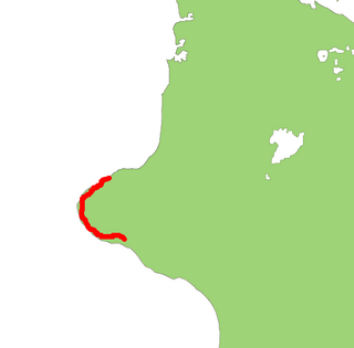
New Plymouth is the major city of the Taranaki Region on the west coast of the North Island of New Zealand. It is named after the English city of Plymouth from where the first English settlers migrated. The New Plymouth District, which includes New Plymouth City and several smaller towns, is the 10th largest district in New Zealand, and has a population of 74,184 – about two-thirds of the total population of the Taranaki Region and 1.7% of New Zealand's population. This includes New Plymouth City (58,300), Waitara (6,483), Inglewood (3,380), Oakura (1,359), Okato (561) and Urenui (429).

Inglewood is a town in the Taranaki Region of New Zealand's North Island. The population was 3,090 in the 2006 census, an increase of 144 from 2001. In 2013 it had risen to 3,243.

Waitara is a town in the northern part of the Taranaki region of the North Island of New Zealand. Waitara is located just off State Highway 3, 15 kilometres (9.3 mi) northeast of New Plymouth. Its population was 6312 in the 2013 census, an increase of 24 from 2006.
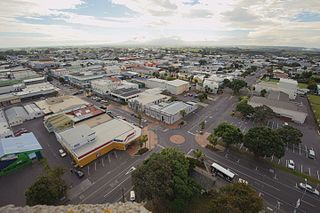
Hawera is the second-largest town in the Taranaki region of New Zealand's North Island, with a population of 12,150. It is near the coast of the South Taranaki Bight. The origins of the town lie in a government military base that was established in 1866, and the town of Hawera grew up around a blockhouse in the early 1870s.
Ngaere is a village situated on State Highway 3, 4 kilometres (2.5 mi) south of Stratford, New Zealand. The name "Ngaere" literally means "swamp" in English, and before settlement, the area was covered by a vast and ancient wetland.
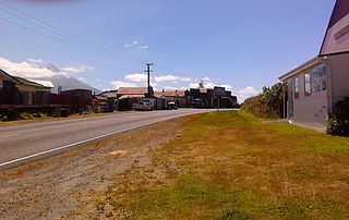
Lepperton is a small village in North Taranaki, New Zealand. It is approximately 6 km (3.7 mi) inland from Waitara township, 5 km (3.1 mi) west of the Waitara River, and 1 km (0.62 mi) east of State Highway 3A, which connects Inglewood to Waitara.
Midhirst is a small village in Taranaki, New Zealand, approximately 4 km north of Stratford, on State Highway 3. Inglewood is 17 km (11 mi) north of Midhirst, and New Plymouth is 35 km (22 mi) to the northwest.
Mokoia is a small settlement in south Taranaki, in the western North Island of New Zealand. It is located on State Highway 3, 10 kilometres (6.2 mi) to the east of Hawera and about 17 km northwest of Patea.
Oakura is a small township in New Plymouth District, Taranaki, in the western North Island of New Zealand. It is located on State Highway 45, 15 kilometres south-west of New Plymouth. Okato is 12 km further south-west. The Oakura River flows past the town and into the North Taranaki Bight. To the south is the Kaitake Range, part of Egmont National Park.
Alton is a small rural community in south Taranaki, in the western North Island of New Zealand. It is located between the towns of Hawera and Patea.
Cardiff is a settlement in inland Taranaki, in the western North Island of New Zealand. It is located five kilometres southwest of Stratford close to Egmont National Park.
Urenui is a settlement in northern Taranaki, in the North Island of New Zealand. It is located on State Highway 3 close to the shore of the North Taranaki Bight, 13 kilometres east of Waitara and 6 km south-west of Mimi. The Urenui River flows past the settlement into the North Taranaki Bight.
Tongaporutu is a settlement in northern Taranaki, in the North Island of New Zealand. It is located on State Highway 3 at the mouth of the Tongaporutu River, 15 kilometres south of Mokau.Tongaporutu is well known in New Zealand for its 'Three Sisters' rock formations and its Maori petroglyphs carved into cave rock walls. However,both the Maori rock carvings and the 'Three Sisters formations are constantly being eroded by the Tasman sea.

Awakino is a settlement in the south of Waitomo District, in the North Island of New Zealand. It is located on State Highway 3 at the mouth of the Awakino River, five kilometres north of Mokau. It is 79 km southwest of Te Kuiti, and 98 km northeast of New Plymouth.
Uruti is a locality in northern Taranaki, in the North Island of New Zealand. It is located on State Highway 3, north-east of Mimi and south-west of Ahititi. The Uruti Stream meets the Mimi River at this point. The river flows past the settlement into the North Taranaki Bight.

Puke Ariki is a combined museum and library at New Plymouth, New Zealand. It also includes a visitor information centre and cafe.
Francis Joseph Mace, also known as Frank Mace, was a Taranaki settler whose exploits during the Taranaki Wars earned him much praise. Chief among his awards was the New Zealand Cross, the highest colonial gallantry award available in New Zealand.
Bell Block is a town in Taranaki, New Zealand. State Highway 3 runs through it. It is 6 km north-east of the centre of New Plymouth and 1 km from the outer edge of New Plymouth at Waiwhakaiho. Waitara is about 9 km to the north-east. New Plymouth Airport is located immediately to the north-east of Bell Block.