
Europa Point, is the southernmost point of Gibraltar. Although not the southernmost point of the Iberian Peninsula, Europa Point defines the boundary between the Straits of Gibraltar in the Atlantic Ocean, and the Alboran Sea within the Mediterranean. At the end of the Rock of Gibraltar, the area is flat and occupied by such features as a playing field and a few buildings. On a clear day, views of North Africa can be seen across the Strait of Gibraltar including Ceuta and the Rif Mountains of Morocco; as well as the Bay of Gibraltar and the Spanish towns along its shores. It is reached from the old town by Europa Road.
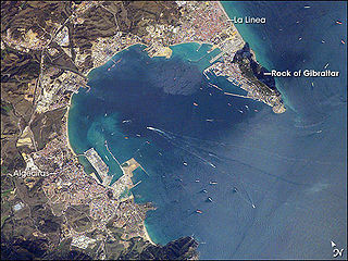
The Bay of Gibraltar, is a bay at the southern end of the Iberian Peninsula. It is around 10 km (6.2 mi) long by 8 km (5.0 mi) wide, covering an area of some 75 km2 (29 sq mi), with a depth of up to 400 m (1,300 ft) in the centre of the bay. It opens to the south into the Strait of Gibraltar and the Mediterranean Sea.

Pascual Madoz Ibáñez was a Spanish politician and statistician.

Villel de Mesa is a municipality in the province of Guadalajara, in the autonomous community of Castile-La Mancha, Spain.

Malagón is a municipality in Ciudad Real, Castile-La Mancha, Spain. As of 2010, it has a population of 8,731.

Belmontejo is a municipality in Cuenca, Castile-La Mancha, Spain. It had a population of 250 as at 2014/15.
Olivares is a city located in the Province of Seville, Spain. According to the 2016 census (INE), the city has a population of 9480 inhabitants. It is located in the Aljarafe, the comarca downstream of the Guadalquivir and west of Seville. It borders Albaida to the west, Gerena to the north, Salteras to the east, and Sanlúcar la Mayor and Villanueva del Ariscal to the south. After the establishment of the House of Olivares, it grew in size and influence, becoming an important urban center in the Aljarafe.

Villalar de los Comuneros is a municipality located in the province of Valladolid, Castile and León, Spain. According to the 2004 census (INE), the municipality had a population of 449 inhabitants.

Bahía del Carnero is a cove with little shelter on the coast of the Arauco Province, Bío Bío Region, Chile to the south of the Punta de Lavapié and north of Lebu at 37° 25' S. At its northern end it contains the mouth of Caleta Yani 37°22′17.54″S73°39′58.96″W and at the southern end, the Caleta Ranquil where it is protected by the promontory of Millonhue. Its coast is low and little forested, and drains the Quiapo River.

Senterada is a village in the province of Lleida and autonomous community of Catalonia, Spain. The municipality includes a small exclave to the north.

Duke of Aliaga is a hereditary title in the Peerage of Spain, accompanied by the dignity of Grandee and granted in 1487 by Ferdinand II to Juan Fernández de Híjar, Count of Aliaga, Duke of Híjar and later also Duke of Lécera.

Juan Fernández de Híjar y Cabrera was a Spanish noble of the House of Híjar. He was the son of Juan Fernández de Híjar, the fifth Baron of Hijar and first lord of Lécera. His mother was Juan Fernandez' second wife, Timbor de Cabrera, daughter of Bernardo de Cabrera, first Count of Módica, XXIV Viscount of Cabrera, XXVI Viscount of Bas, and II Viscount of Osuna.

Cala Arenas is a beach situated near the city of Algeciras in Spain, within the El Estrecho Natural Park. It is located at the southern end of the Bay of Gibraltar and faces the Strait of Gibraltar. It measures about 400 metres (1,300 ft) long by about 30 metres (98 ft) deep. The beach is somewhat difficult to access, but can be reached via coastal paths from Punta Carnero and Punta del Fraile. It consists of a series of three small coves of similar appearance, with beaches of rocks and small stones. Both the terrestrial and marine environment of the area lies within the natural park. Its surroundings are largely undisturbed by human activity; the nearest settlement is the coastal community of Getares, a small outlying development of the city of Algeciras located about 1 km to the north. The beach is framed by cliffs and the Isla de las Palomas lies a short distance offshore.

Punta Carnero Lighthouse is an active lighthouse located on the headland known as Punta Carnero to the south of Algeciras, Spain. The lighthouse was designed and built by Jaime Font, who also designed the lighthouse at Chipiona. Opened in 1874, it overlooks the Strait of Gibraltar.

The Aqueduct of Algeciras is one of the most important buildings in Algeciras, Spain. Numerous textbooks, dictionaries and guidebooks cite this building as Arabic or Roman, but it was built in the eighteenth century.

The siege of Algeciras (1369) was undertaken during the period of the Reconquest of Spain by Muhammad V, the Emir of Granada to reclaim the city of Al-Hadra Al-Yazirat, called Algeciras by the Christians, in the Kingdom of Castile. The siege lasted just three days, and the sultan was victorious. The Muslims thus regained a major city which had been in Castilian hands since Alfonso XI of Castile took it from the Moroccans after the long 1342–1344 siege. Ten years after the capture of the city, in 1379 the sultan of Granada decided to completely destroy the city to prevent it falling into Christian hands. It was impossible to defend the place at a time when the Muslim kings of the Iberian Peninsula had lost much of military power they enjoyed in earlier centuries.

The ruins of Fuerte de San Diego are the remains of a castle located in Algeciras, Spain. The castle was built in 1730 following the Capture of Gibraltar in 1704.

Fuerte de Punta Carnero was a fort near Algeciras in Spain. It was built before 1735 and was destroyed in 1810 to deny it to the French. Today all that remains are ruined foundations which are a registered Bien de Interés Cultural landmark.

Amorós is a locality belonging to the municipality of Sant Guim de Freixenet, in the Province of Lleida, Catalonia, Spain. As of 2020, it has a population of 12. A standalone municipality in the past, it was absorbed by the municipality of Sant Guim de Freixenet in between 1842 and 1857. The Madoz dictionary described its location as lying "on a plain with free ventilation and a healthy climate".
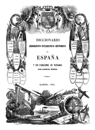
The Diccionario geográfico-estadístico-histórico de España y sus posesiones de Ultramar is a geographic handbook of Spain. Originally published in 16 volumes between 1845 and 1850, it was edited and directed by Pascual Madoz. A widely known work in Spain, used as reference work, it stands out in terms of the sheer amount of information, its systematization as well as for covering the whole geography of Spain.
