 | |
 Punta Cometa | |
| Geography | |
|---|---|
| Location | Pacific Ocean |
| Coordinates | 15°39′30″N96°33′22″W / 15.65833°N 96.55611°W |
Punta Cometa is a peninsula on the Pacific Coast of Mexico.
| | |
| Punta Cometa | |
| Geography | |
|---|---|
| Location | Pacific Ocean |
| Coordinates | 15°39′30″N96°33′22″W / 15.65833°N 96.55611°W |
Punta Cometa is a peninsula on the Pacific Coast of Mexico.
It extends into the Pacific Ocean within Mazunte municipality of Oaxaca state, in western Mexico.
It is the southernmost point in the state of Oaxaca. [1] [2]

Oaxaca, officially the Free and Sovereign State of Oaxaca, is one of the 32 states that compose the Federative Entities of the United Mexican States. It is divided into 570 municipalities, of which 418 are governed by the system of usos y costumbres with recognized local forms of self-governance. Its capital city is Oaxaca de Juárez.

The Isthmus of Tehuantepec is an isthmus in Mexico. It represents the shortest distance between the Gulf of Mexico and the Pacific Ocean. Before the opening of the Panama Canal, it was a major overland transport route known simply as the Tehuantepec Route. The name is taken from the town of Santo Domingo Tehuantepec in the state of Oaxaca; this was derived from the Nahuatl term Tēcuāntepēc.
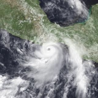
Hurricane Pauline was one of the deadliest Pacific hurricanes to make landfall in Mexico. The sixteenth tropical storm, eighth hurricane, and seventh major hurricane of the 1997 Pacific hurricane season, Pauline developed out of a tropical wave from Africa on September 16, 1997, moving across South America and into the Pacific Ocean. On October 5, the depression intensified into a tropical storm early the next day and by October 7, Pauline had reached hurricane intensity. It initially moved eastward, then turned northwestward and quickly strengthened to reach peak winds of 135 mph (217 km/h). It paralleled the Mexican coastline a short distance offshore before weakening and making landfall near Puerto Ángel, Oaxaca, on October 9, and dissipated the next day.

Mazunte is a small beach town on the Pacific coast of Oaxaca, Mexico. It is located 22 km southwest of San Pedro Pochutla on coastal Highway 200. Mazunte is located some 10 km to the west of Puerto Ángel and just about 1 km from San Agustinillo and 264 km south of the capital of Oaxaca. There are two etymologies for the name. Some sources state that “Mazunte” is derived from a Nahuatl phrase, “maxotetia” which means “please deposit eggs here.” However, older residents of the community state that it is from the word “mizontle,” used by locals to refer to a crab species that used to be very abundant in the area.

San Pedro Pochutla is a city and municipality located in the south of Oaxaca state, Mexico next to the Pacific Ocean. It is an important commercial, transportation and administrative hub for the Pochutla District in the east of the Costa Region. Pochutla is located at the junction of coastal Highway 200 and Highway 175 to Oaxaca, with 175 functioning as the town's main thoroughfare. Its name means "place of kapok trees ", and most of the city is built on a lakebed which was drained during the colonial period. The municipality is best known as being the home of the oceanside communities of Puerto Ángel and Zipolite.

Hurricane Rick was the second-latest hurricane in the calendar year to make landfall in Mexico. The eighteenth named storm and ninth and final hurricane of the 1997 Pacific hurricane season, Rick was a short-lived Category 2 hurricane on the Saffir-Simpson Hurricane Scale that weakened before making landfall in Mexico on November 10. It hit almost a month after the more powerful Hurricane Pauline made landfall in the same area. Most of the damage associated with Pauline was exacerbated by the weaker Rick, which struck during rebuilding efforts.

The Costa Chica of Guerrero is an area along the south coast of the state of Guerrero, Mexico, extending from just south of Acapulco to the Oaxaca border. Geographically, it consists of part of the Sierra Madre del Sur, a strip of rolling hills that lowers to coastal plains to the Pacific Ocean. Various rivers here form large estuaries and lagoons that host various species of commercial fish.

Mermejita is a small beach village in the central part of Oaxaca's coast, west of San Agustinillo and Mazunte and east of Chacahua. Until recently, the area was completely uninhabited, but now it is attracting adventurers who are building Robinson Crusoe-style houses, using local materials. It is known as a nudist beach, and one of only two places in Oaxaca where the rare leatherback turtle nests.

Arriaga Municipality is a municipality in the Mexican state of Chiapas, in southern Mexico. It covers an area of 653.3 km2 (252.2 sq mi) and is bordered by the Pacific Ocean and the neighbouring state of Oaxaca, as well as by the Chiapas municipalities of Cintalapa, Jiquipilas, Villaflores and Tonalá.
Cuajinicuilapa is a municipality in the Mexican state of Guerrero. The municipal seat lies at Cuajinicuilapa. The municipality covers an area of 857.1 km². In 2020, the municipality had a total population of 26,627, up from 25,537 in 2005.
Mario Alberto González, better known by his ring name Rey Cometa, is a Mexican luchador, working for the Mexican professional wrestling promotion Consejo Mundial de Lucha Libre (CMLL). Rey Cometa first gained national exposure when he worked for Asistencia Asesoría y Administración (AAA) from 2005 until 2008. In AAA, he was a part of the group Real Fuerza Aérea, consisting of young high flying wrestlers. As is usual with masked wrestlers in Mexico, Cometa's real name was not a matter of public record until he lost his mask in a match in September 2012. With his brother Espíritu Negro as Los Atrapa Sueños, they are one-time Mexican National Tag Team Champions and one-time Mexican National Trios Champions in their first reign. He is also a former holder of the Mexican National Welterweight Championship.

Tropical Storm Carlos was the first of five tropical cyclones to make landfall during the 2003 Pacific hurricane season. It formed on June 26 from a tropical wave to the south of Mexico. It quickly strengthened as it approached the coast, and early on June 27 Carlos moved ashore in Oaxaca with winds of 65 mph (105 km/h). The storm rapidly deteriorated to a remnant low, which persisted until dissipating on June 29. Carlos brought heavy rainfall to portions of southern Mexico, peaking at 337 mm (13.3 in) in two locations in Guerrero. Throughout its path, the storm damaged about 30,000 houses, with a monetary damage total of 86.7 million pesos. At least nine people were killed throughout the country, seven due to mudslides and two from river flooding; there was also a report of two missing fishermen.

Tropical Storm Cristina was the third tropical cyclone to make landfall along the Pacific Coast of Mexico in 10 days. On July 1, an area of disturbed weather developed into a tropical depression off the coast of Central America. The depression strengthened into Tropical Storm Cristina on July 2 as it moved west-northwest. Cristina was almost a hurricane at the time of its landfall near Puerto Ángel on July 3. The cyclone dissipated over the mountains of Mexico on the same day. Tropical Storm Cristina claimed 13 lives and left 62 missing. Eleven fishing boats were reported missing and 350 people were left homeless

The Costa Region or Costa Chica lies on the Pacific coast of the state of Oaxaca, Mexico, south of the more mountainous Sierra Sur inland from the coast. It includes the districts of Jamiltepec, Juquila and Pochutla.
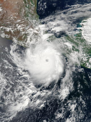
Hurricane Carlotta was the easternmost tropical cyclone in the Eastern Pacific to make landfall at hurricane intensity since 1966. The third tropical cyclone and third named storm of the 2012 Pacific hurricane season, Carlotta developed slowly into a tropical depression from a tropical wave southwest of Central America on June 14. It moved generally west-northwestward and by the following day, strengthened into tropical storm strength. Thereafter, gradual intensification occurred and the storm reached hurricane strength on June 15. Rapid intensification ensued further, as Carlotta peaked as a 110 mph (180 km/h) Category 2 hurricane on the same day. At 0100 UTC the following day, Carlotta made landfall near Puerto Escondido, the easternmost landfalling Pacific hurricane in recorded history at the time. The next day the storm began to weaken as it moved onshore Southwestern Mexico. Carlotta continued to weaken rapidly, eventually dissipating on June 16.

Tropical Storm Carlotta was a moderately strong tropical cyclone that caused flooding in several states in southwestern and central Mexico. Carlotta, the third named storm of the 2018 Pacific hurricane season, formed as the result of a breakdown in the Intertropical Convergence Zone. On June 12, a broad area of low pressure developed several hundred miles south of Mexico and strengthened into a tropical storm by June 15. The next day, the system stalled unexpectedly within a favorable environment, which led to more intensification than originally anticipated. Early on June 17, Carlotta reached peak intensity with maximum sustained winds of 65 mph (100 km/h) and a minimum central pressure of 997 mbar while located only 30 mi (50 km) south-southeast of Acapulco. The system then began to interact with land and experience wind shear, which resulted in the storm weakening to tropical depression status later in the day. The system weakened to a remnant low early on June 19 and dissipated several hours later.

Tropical Storm Vicente was an unusually small tropical cyclone that made landfall as a tropical depression in the Mexican state of Michoacán on October 23, 2018, causing deadly mudslides. The 21st named storm of the 2018 Pacific hurricane season, Vicente originated from a tropical wave that departed from Africa's western coast on October 6. The wave traveled westward across the Atlantic and entered the Eastern Pacific on October 17. The disturbance became better defined over the next couple of days, forming into a tropical depression early on October 19. Located in an environment favorable for further development, the system organized into Tropical Storm Vicente later that day.

Tropical Storm Ileana was a small tropical cyclone that affected western Mexico in early August 2018, causing deadly flooding. The eleventh tropical cyclone and ninth named storm of the 2018 Pacific hurricane season, Ileana originated from a tropical wave that the National Hurricane Center began monitoring on July 26 as the wave left the west coast of Africa. The wave traveled across the Atlantic Ocean with no thunderstorm activity, before crossing into the Eastern Pacific Ocean early on August 4. Rapidly developing, the disturbance organized into a tropical depression on the evening of the same day. Initially, the depression was well-defined, but it soon degraded due to northerly wind shear. Despite the unfavorable conditions, the system began to strengthen on August 5, becoming Tropical Storm Ileana. A day later, on August 6, Ileana began to develop an eyewall structure as it reached its peak intensity with winds of 65 mph (100 km/h) and a pressure of 998 mbar (29.47 inHg). The storm gradually became intertwined with the nearby Hurricane John; over the next day, the circulation of John disrupted Ileana before ultimately absorbing it on August 7.
Cometa may refer to:

Pontobdella californiana is a species of marine leech found off the southern Pacific coast of North America. They are relatively large, greenish, tubercle-covered leeches who parasitize skates and rays. The species was scientifically described in 2015 based on previously-collected specimens and has since been recorded elsewhere.
{{###MULTILINE_MARKER_TAG###}}
| | This article about a location in the Mexican state of Oaxaca is a stub. You can help Wikipedia by expanding it. |