
The River Teign is a river in the county of Devon, England. It is 31 mi (50 km) long and rises on Dartmoor, becomes an estuary just below Newton Abbot and reaches the English Channel at Teignmouth.

Newton Abbot is a market town and civil parish on the River Teign in the Teignbridge District of Devon, England. Its population was 24,029 in 2011, and was estimated at 26,655 in 2019. It grew rapidly in the Victorian era as the home of the South Devon Railway locomotive works. This later became a major steam engine shed, retained to service British Railways diesel locomotives until 1981. It now houses the Brunel industrial estate. The town has a race course nearby, the most westerly in England, and a country park, Decoy. It is twinned with Besigheim in Germany and Ay in France.

The River Axe is a river in South West England. The river is formed by water entering swallets in the limestone and rises from the ground at Wookey Hole Caves in the Mendip Hills in Somerset, and runs through a V-shaped valley. The geology of the area is limestone and the water reaches Wookey Hole in a series of underground channels that have eroded through the soluble limestone. The river mouth is in Weston Bay on the Bristol Channel.

The Riviera Line is the railway between the city of Exeter, towns Dawlish and Teignmouth, and the English Riviera resorts of Torbay in Devon, England. Its tracks are shared with the Exeter to Plymouth Line along the South Devon sea wall. It is part of the Network Rail Route 12.

Newton Abbot railway station serves the market town of Newton Abbot in Devon, England. It is 214 miles 5 chains (345 km) from London Paddington. The station today is managed by Great Western Railway, who provide train services along with CrossCountry.

Abbotskerswell is a village and civil parish in the English county of Devon. The village is in the north part of the parish and is located two miles (3 km) south of the town of Newton Abbot, 7 miles (11 km) from the seaside resort of Torquay and 32 miles (51 km) from the city of Plymouth. The A381 road between Newton Abbot and Totnes runs down the western side of the parish and the main railway line between these two towns forms part of its eastern boundary.

Bradley is a medieval manor house in Newton Abbot, Devon, England. It is set amongst woodland and meadows in the valley of the River Lemon about a half mile to the west of the main town. The house is now in the ownership of the National Trust.
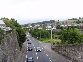
Kingskerswell is a village and civil parish within Teignbridge local government district in the south of Devon, England. The village grew up where an ancient track took the narrowest point across a marshy valley and it is of ancient foundation, being mentioned in the Domesday Book. It has a church dating back to the 14th century and the ruins of a manor house of similar date. The coming of the railway in the 1840s had a large effect on the village, starting its conversion into a commuter town. The village is a major part of the electoral ward called Kerswell-with-Combe. This ward had a population of 5,679 at the 2011 census.
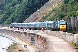
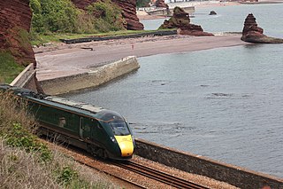
The South Devon Railway sea wall is situated on the south coast of Devon in England. A footpath runs alongside the railway between Dawlish Warren and Dawlish, then another footpath forms a continuation to the sea front promenade at Teignmouth. Both of these form part of the South West Coast Path.

Coffinswell is a small village in South Devon, England, just off the A380, the busy Newton Abbot to Torquay road. It lies within Teignbridge District Council.

The River Lemon is a 9.9 miles river in the county of Devon in southwest England. It is a tributary of the River Teign, starting on Dartmoor by Haytor, and ending in Newton Abbot. It rises on the south-east side of Dartmoor near Haytor, joins with the River Sig and the Langworthy Brook at Sigford, then passes the village of Bickington. Lower down, it is joined by the Kestor Brook and it then flows through the woods in Bradley Valley, past the manor house of Bradley, and through the town of Newton Abbot where it flows through a 440-yard-long (400 m) tunnel below the town centre. Just below the town, the river joins the River Teign at 50.517°N 3.607°W, near the head of its estuary.
The South Devon Railway Company built and operated the railway from Exeter to Plymouth and Torquay in Devon, England. It was a 7 ft 1⁄4 in broad gauge railway built by Isambard Kingdom Brunel.

The Haldon Hills, usually known simply as Haldon, is a ridge of high ground in Devon, England. It is situated between the River Exe and the River Teign and runs northwards from Teignmouth, on the coast, for about 24 km (15 mi) until it dwindles away north west of Exeter at the River Yeo, just south of Crediton. The highest points of just over 250 metres (820 ft) lie to the south west of Exeter. The southernmost part is known as Little Haldon; it is partially separated from the main bulk of the hills by a col formed by the valleys of the Dawlish Water to the east and the valley at Rixdale to the west.

The Hackney Canal was a short canal in Devon, England, that linked the Hackney Clay Cellars to the River Teign. It was privately built by Lord Clifford in 1843, and throughout its life carried ball clay for use in the production of pottery. It closed in 1928, when its function was replaced by road vehicles.
Berry's Wood is an Iron Age hill fort situated close to Newton Abbot in Devon, England. The fort is situated at about 75 metres above sea level on a commanding promontory above the River Lemon with views down the Teign Estuary. It lies on the hilltop above Bradley Manor.

Annery kiln is a former limekiln of the estate of Annery, in the parish of Monkleigh, North Devon. It is situated on the left bank of the River Torridge near Half-Penny Bridge, built in 1835, which connects the parishes of Monkleigh and Weare Giffard. Running by it today is A386 road from Bideford to Great Torrington. Weare Giffard is the start of the tidal section of the River Torridge, and thus the kiln was sited here to import by river raw materials for the kiln, the product of which was lime fertiliser for use on inland agricultural fields. The old lime kiln is thus situated between the River Torridge and the now filled-in Rolle Canal built circa 1827 and railway that ran formerly from Bideford to Torrington, opened in 1872 and closed in 1966. The old trackbed now forms a stretch of the Tarka Trail.

The county of Somerset is in South West England, bordered by the Bristol Channel and the counties of Bristol and Gloucestershire to the north, and Wiltshire to the east, Dorset to the south, and Devon to the west. The climate, influenced by its proximity to the Atlantic Ocean and the prevailing westerly winds, tends to be mild, damp and windy.
The Exeter–Plymouth line, also called the South Devon Main Line, is a central part of the trunk railway line between London Paddington and Penzance in the southern United Kingdom. It is a major branch of the Great Western Main Line and runs from Exeter St Davids to Plymouth, from where it continues as the Cornish Main Line. It was one of the principal routes of the Great Western Railway which in 1948 became part of the Western Region of British Railways and is presently operated by Network Rail.

Highweek, less commonly called Highweek Village is an ecclesiastical parish, former manor and village, now a suburb of Newton Abbot, but still retaining its village identity, in the civil parish of Newton Abbot, in the Teignbridge district, in the county of Devon, England. It is prominent and recognisable due to its high location on a ridge on the north western edge of the town. The area is the centre of the modern electoral ward of Bradley. That ward's population at the 2011 census was 5,043.

Teigngrace is a civil parish centred on a hamlet that lies about two miles north of the town of Newton Abbot in Devon, England. According to the 2001 census, its population was 235, compared to 190 a century earlier. The western boundary of the parish mostly runs along the A382 road; its short northern boundary along the A38; and its eastern partly along the rivers Bovey and Teign. It comes to a point at its southern extremity, near Newton Abbot Racecourse. The parish is surrounded, clockwise from the north, by the parishes of Bovey Tracey, Kingsteignton, Newton Abbot and a small part of Ilsington.

