Pushmataha County, Sequoyah

Last updated

Pushmataha County was a proposed political subdivision created by the Sequoyah Constitutional Convention. The convention, meeting in Muskogee, Indian Territory in 1905, established the political and administrative layout of a prospective U.S. state it called the State of Sequoyah.

Contents

The State of Sequoyah's proposed boundaries. Sequoyah map.jpg
The State of Sequoyah's proposed boundaries.

Sequoyah was an attempt by the Five Civilized Tribes and others in the Indian Territory—who did not wish to be incorporated into an American state—to establish full statehood for the territory. Although their attempt to achieve statehood was unsuccessful, many of their deliberations in establishing proposed counties proved useful to the framers of Oklahoma, who met just two years later for the purpose of establishing the State of Oklahoma.

The boundaries of modern-day Choctaw, Pushmataha and McCurtain counties in Oklahoma are derived largely from the work of the Sequoyah Constitutional Convention. [1]

The First Pushmataha County

The revered Choctaw Indian warrior and statesman Chief Pushmataha, namesake of the Pushmataha District in the Choctaw Nation, was similarly honored by the framers of Sequoyah, who designated a county in his honor. Neighboring counties were to be named for territorial and U.S. officials, including Bixby County for Tams Bixby (contiguous with today’s Atoka County, Oklahoma) and Hitchcock County for Ethan Allan Hitchcock (contiguous with today’s Choctaw County, Oklahoma).

Sequoyah’s framers drew county boundaries to respond to the Public Land Survey System established by the American government for the Indian Territory. With its orderly grid of townships and ranges, it was deemed well-suited for the demands of a modern society. The Choctaw Nation’s counties, while drawn with great thought and using recognizable, logical landmarks as their county borders, would not be economically viable after statehood. Some counties, such as Cedar County, did not include towns of any size or significance, and would be bereft of any means of raising local taxes or revenue. [2]

The issue of establishing county seats was an important one. Prior to and after Oklahoma’s statehood in 1907 the issue would consume several counties, mostly in the western part of the state, in which leading towns battled for legal supremacy. In the case of the proposed Pushmataha County, Sequoyah however, its future leaders agreed to designate the area’s most important and promising town as seat of government.

Pushmataha County, Sequoyah with Antlers as its county seat, was proposed, in general, to assume the territory then encompassed by portions of Jack’s Fork County, Cedar County, Kiamitia County (Kiamichi County) and Wade County of the Choctaw Nation.

The southeastern region of the proposed State of Sequoyah, like that of the State of Oklahoma which followed, presented special problems. The Kiamichi Mountains then, as now, occupy vast areas making population centers virtually impossible to achieve. Pushmataha County, Sequoyah was drawn with its principal commercial center—Antlers—in its southeastern corner. This was necessary to balance the competing needs of merchants in Antlers, Hugo, Atoka and other towns, as well as revenues projected to be obtained by the future county governments.

This was not an ideal arrangement as it required certain residents of the far-flung county to have to travel by train to reach their county seat. But no other arrangement appeared viable. Very logically, the town of Albion was drawn outside the county borders, grouped with Talihina, Wilburton and Poteau in a neighboring county to be called Wade County. Several years later, as Oklahoma was created, this situation was reversed and Albion was added to what is now Pushmataha County, Oklahoma.

The Second Pushmataha County

The usefulness of these arrangements did not escape the attention of Oklahoma’s framers, who in 1907 borrowed, largely intact, the concept and proposed boundaries of Pushmataha County, Hitchcock County, and McCurtain County for present-day Pushmataha County, Choctaw County and McCurtain County.

County seats stayed as designated by the framers of Sequoyah, and county boundaries stayed generally the same. In the case of Pushmataha County only two differences may be noted: Albion and its surrounding townships and ranges were added; and Daisy and its surrounding townships and ranges were removed.

The recorded minutes of the Sequoyah Constitutional Convention’s committee on counties have been lost, so no additional information on the proposed Pushmataha County is available. [3]

Related Research Articles

Pushmataha County, Oklahoma County in Oklahoma, United States

Pushmataha County is a county in the southeastern part of the U.S. state of Oklahoma. As of the 2010 census, the population was 11,572. Its county seat is Antlers.

Choctaw County, Oklahoma County in Oklahoma, United States

Choctaw County is a county located in the U.S. state of Oklahoma. As of the 2010 census, the population was 15,205. Its county seat is Hugo.

State of Sequoyah proposed state in what is now eastern Oklahoma

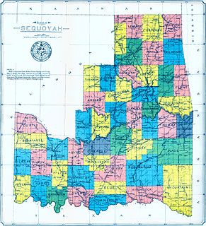
The State of Sequoyah was a proposed state to be established from the Indian Territory in the eastern part of present-day Oklahoma. In 1905, with the end of tribal governments looming, Native Americans of the Five Civilized Tribes—the Cherokee, Choctaw, Chickasaw, Creek (Muscogee), and Seminole—in Indian Territory proposed to create a state as a means to retain control of their lands. Their intention was to have a state under Native American constitution and governance. The proposed state was to be named in honor of Sequoyah, the Cherokee who created a writing system in 1825 for the Cherokee language.

Kiamichi River

The Kiamichi River is a river in southeastern Oklahoma, United States of America. A tributary of the Red River of the South, its headwaters rise on Pine Mountain in the Ouachita Mountains near the Arkansas border. From its source in LeFlore County, Oklahoma, it flows approximately 177 miles (285 km) to its confluence with the Red River south at Hugo, Oklahoma.

Kiamitia County, also known as Kiamichi County, was a political subdivision of the Choctaw Nation, Indian Territory. The county formed part of the nation's Pushmataha District, or Third District, one of three administrative super-regions.

Hitchcock County was a proposed political subdivision created by the Sequoyah Constitutional Convention. The convention, meeting in Muskogee, Indian Territory in 1905, established the political and administrative layout of a prospective U.S. state it called the State of Sequoyah.

Cedar County was a political subdivision of the Choctaw Nation in the Indian Territory. The county formed part of the nation’s Apukshunnubbee District, or Second District, one of three administrative super-regions.

Jack's Fork County, also known as Jack Fork County, was a political subdivision of the Choctaw Nation of Indian Territory. The county formed part of the nation's Pushmataha District, or Third District, one of three administrative super-regions.

Jackson County was a political subdivision of the Choctaw Nation of Indian Territory, prior to Oklahoma being admitted as a state. The county formed part of the Nation's Pushmataha District, or Third District, one of three administrative super-regions.

Nashoba County was a political subdivision of the Choctaw Nation of Indian Territory. The county formed part of the Nation’s Apukshunnubbee District, or Second District, one of three administrative super-regions in the Nation. This territory was later made part of the state of Oklahoma.

Pushmataha District

Pushmataha District was one of three administrative super-regions comprising the former Choctaw Nation in the Indian Territory. Also called the Third District, it encompassed the southwestern one-third of the nation.

Blue County was a political subdivision of the Choctaw Nation of Indian Territory, prior to Oklahoma being admitted as a state. The county formed part of the Nation’s Pushmataha District, or Third District, one of three administrative super-regions.

Wade County was a political subdivision of the Choctaw Nation of Indian Territory, prior to Oklahoma being admitted as a state. The county formed part of the Nation's Apukshunnubbee District, or First District, one of three administrative super-regions.

Atoka County, Choctaw Nation Former political subdivision of the Choctaw Nation

Atoka County was a political subdivision of the Choctaw Nation of Indian Territory, prior to Oklahoma being admitted as a state. The county formed part of the Nation's Pushmataha District, or Third District, one of three administrative super-regions.

Towson County was a political subdivision of the Choctaw Nation of Indian Territory, prior to Oklahoma being admitted as a state. The county formed part of the Nation's Apukshunnubbee a District, or Second District, one of three administrative super-regions.

Bok Tuklo County was a political subdivision of the Choctaw Nation of Indian Territory, prior to Oklahoma being admitted as a state. The county formed part of the Nation’s Apukshunnubbee District, or Second District, one of three administrative super-regions. The subdivision was located within the current McCurtain County.

Bok Tuklo County was a political subdivision of the Choctaw Nation of Indian Territory, prior to Oklahoma being admitted as a state. The county formed part of the Nation’s Apukshunnubbee District, or Second District, one of three administrative super-regions.

Eagle County was a political subdivision of the Choctaw Nation of Indian Territory, prior to Oklahoma being admitted as a state. The county formed part of the Nation's Apukshunnubbee District, or Second District, one of three administrative super-regions.

Red River County was a political subdivision of the Choctaw Nation of Indian Territory, prior to Oklahoma being admitted as a state. The county formed part of the Nation's Apukshunnubbee District, or Second District, one of three administrative super-regions.

Sugar Loaf County was a political subdivision of the Choctaw Nation of Indian Territory, prior to Oklahoma being admitted as a state. The county formed part of the Nation's Moshulatubbee District, or First District, one of three administrative super-regions.

References

  1. Edwin C. McReynolds, Historical Atlas of Oklahoma, 1965.
  2. County boundaries included the Kiamichi River—separating Cedar from Jack’s Fork counties; Frazier Creek—separating Cedar and Towson counties; Beaver Creek—separating Jack’s Fork and Kiamitia (Kiamichi) counties; the Winding Stair Mountains—separating Jack’s Fork and Cedar counties from Wade County; and the Middle Boggy Creek, separating Jack’s Fork and Atoka counties.
  3. Amos Maxwell, The Sequoyah Constitutional Convention, 1953.