
Southern Norway is the geographical region (landsdel) along the Skagerrak coast of southern Norway. The region is an informal description since it does not have any governmental function. It roughly corresponds to the old petty kingdom of Agder as well as the two present-day counties of Vest-Agder and Aust-Agder. The total combined area of Vest-Agder and Aust-Agder counties is 16,493 square kilometres (6,368 sq mi). The name is relatively new, having first been used in Norway around 1900.

Kongshavn or Kongshamn is a village in the municipality of Arendal in Aust-Agder county, Norway. Its population (2009) was 862. Kongshavn is located on the north side of the island of Tromøya, across the Tromøysundet strait from the village of Eydehavn. It is about 11 kilometres (6.8 mi) east of the town of Arendal and it is directly west of the village of Åmdalsøyra.
Barbu is part of the town of Arendal in Aust-Agder county, Norway. It is also a former municipality which existed from 1878 until 1902 when it was merged into Arendal. The 15.7-square-kilometre (6.1 sq mi) municipality was located just to the north of the 0.34-square-kilometre (84-acre) town of Arendal. The administrative centre of the small, urban municipality was called Barbu as well. Barbu Church was the church for the municipality. Today, the name Barbu refers to the village-like place located in head of the Galtesundet strait. Barbu is also a parish (sogn) in the Arendal prosti (deanery) within the Diocese of Agder og Telemark.

Tromøy is a former municipality in Aust-Agder county, Norway. The 30-square-kilometre (12 sq mi) municipality existed from 1878 until its dissolution in 1992. The municipal area is now part of the municipality of Arendal. The administrative centre was the village of Brekka where the historic Tromøy Church is located. The municipality encompassed all of the island of Tromøya as well as many smaller surrounding islands such as Merdø, Gjesøya, Skilsøy, and Tromlingene.
MacGregor Pusnes formerly known as Aker Pusnes, Aker Kværner Pusnes and Maritime Pusnes, established in 1875, is a designer and supplier of all types of deck machinery and mooring systems for marine and offshore applications. In addition, Aker Pusnes has developed and supplied bow loading and offloading systems for both simple and sophisticated operations offshore. The company is a subsidiary of Aker Solutions and located on Tromøya island near the city of Arendal in Aust-Agder county, Norway.

Eydehavn or Eydehamn is a village in the municipality of Arendal in Aust-Agder county, Norway. The village is located about 10 kilometres (6.2 mi) northeast of the centre of the town of Arendal, about 2 kilometres (1.2 mi) northeast of the village of Saltrød, about 2 kilometres (1.2 mi) south of the village of Strengereid, and just across the Tromøysundet strait from Kongshamn on the island of Tromøy. The village is named after Sam Eyde, the Norwegian engineer and industrialist. The local sports team is called IL Sørfjell. Eydehavn has about 1,100 residents as of 2015.

Tromøya or Tromøy is the largest island in Southern Norway. The 28.6-square-kilometre (11.0 sq mi) island is entirely located in the municipality of Arendal in Aust-Agder county, Norway. The island has about 5,300 residents which gives it a population density of about 185 inhabitants per square kilometre (480/sq mi). The island is located directly across the harbor from the town of Arendal. The highest point on the island is the 95-metre (312 ft) tall Vardåsen. The island is separated from the mainland to the north by the Tromøysundet strait and it is separated from the island of Hisøya to the southwest by the Galtesundet strait.

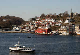
Brattekleiv is a village in Arendal municipality in Aust-Agder county, Norway. The village is located along the Galtesundet strait on the southwestern shore of the island of Tromøy. The village lies about 1 kilometre (0.62 mi) southwest of the town of Arendal which is located across the strait. The smaller industrial village of Pusnes lies immediately north of Brattekleiv, the small village of Revesand lies just south of the village, and the village of Færvik lies a short distance to the east.

Færvik is a village in Arendal municipality in Aust-Agder county, Norway. The village is located on the southwestern part of the island of Tromøy. It sits east of Pusnes and Brattekleiv and north of Revesand. Færvik Church is located just southwest of the village. Færvik was the administrative centre of the old Tromøy municipality from 1878 until 1992.

Kolbjørnsvik is a village in Arendal municipality in Aust-Agder county, Norway. The village is located on the northern part of the island of Hisøya, across the harbour from the town of Arendal. The village of His and the Hisøy Church lie about 2 kilometres (1.2 mi) south of Kolbjørnsvik. The former municipality of Hisøy had its municipal government located in this village. Today, the village is considered to be part of the town of Arendal, so separate population statistics are not kept.

Nedenes is a village in Arendal municipality in Aust-Agder county, Norway. The village is located in the southern part of Arendal, just north of the municipal border with Grimstad. The Norwegian County Road 420 runs through the village heading north to the village of Rød and onwards to the island of Hisøya to the north. Engene Church is located in Nedenes.
Sagene is a village in Arendal municipality in Aust-Agder county, Norway. The village is located about 2 kilometres (1.2 mi) northwest of the village of Strengereid in the Moland area of Arendal. The lake Langangsvannet lies just east of the village.

Saltrød is a village in Arendal municipality in Aust-Agder county, Norway. The village is located along the Norwegian County Road 410, about 5 kilometres (3.1 mi) northeast of the town of Arendal and about 2 kilometres (1.2 mi) southwest of the village of Eydehavn. The village lies along the Tromøysundet strait, looking across the water towards the island of Tromøy. Stokken Church is located in Saltrød.
Åmdalsøyra or Omdalsøyra is a village in Arendal municipality in Aust-Agder county, Norway. The village is located along the Tromøysundet strait on the northern shore of the island of Tromøy. The village of Kongshavn lies just to the southwest of Åmdalsøyra and the village of Eydehavn lies just across the strait on the mainland.

Aust-Agder District Court is a court of first instance under Agder Court of Appeal in Norway. The former district courts of Holt, Nedenes and Sand was incorporated in Aust-Agder District Court from September 2004.

Østre Agder is a district or region in Aust-Agder county in southern Norway. The district covers the eastern, coastal areas of the county including the eight municipalities of Arendal, Tvedestrand, Risør, Grimstad, Gjerstad, Vegårshei, Åmli, and Froland. The city of Arendal is the largest city in the region. Other cities in the district include Tvedestrand, Grimstad, and Risør. This region is bounded by Telemark county to the north, by the Setesdal region to the northwest, and by the Kristiansand Region to the southwest.


