Harran is a rural town and district of Urfa in southeastern Turkey. It is approximately 40 kilometres southeast of Urfa and 20 kilometres from the Syrian border crossing at Akçakale.

Aššur (; Sumerian: 𒀭𒊹𒆠 AN.ŠAR2KI, Assyrian cuneiform: Aš-šurKI, "City of God Aššur"; Syriac: ܐܫܘܪ Āšūr; Old Persian 𐎠𐎰𐎢𐎼Aθur, Persian: آشور: Āšūr; Hebrew: אַשּׁוּר, ʾAššūr, Arabic: اشور), also known as Ashur and Qal'at Sherqat, was the capital of the Old Assyrian city-state (2025–1364 BC), the Middle Assyrian Empire (1363–912 BC), and for a time, of the Neo-Assyrian Empire (911–609 BC). The remains of the city lie on the western bank of the Tigris River, north of the confluence with its tributary, the Little Zab, in what is now Iraq, more precisely in the al-Shirqat District of the Saladin Governorate.
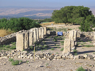
Tel Hazor, also Chatsôr, translated in LXX as Hasōr, named in Arabic Tell Waqqas / Tell Qedah el-Gul, is an archaeological tell at the site of ancient Hazor, located in Israel, Upper Galilee, north of the Sea of Galilee, in the northern Korazim Plateau. Both as a Middle Bronze Age Canaanite city and as an Israelite one, Hazor was the largest fortified city in the country and one of the most important in the Fertile Crescent. It maintained commercial ties with Babylon and Syria, and imported large quantities of tin for the bronze industry. In the Book of Joshua, Hazor is described as "the head of all those kingdoms". Though some scholars do not consider the Book of Joshua to be historically accurate, archaeological excavations have emphasized its importance.
Aššur-rabi II, inscribed maš-šur-GAL-bi, "(the god) Aššur is great," was king of Assyria 1012–972 BC. Despite his lengthy reign, one of the longest of the Assyrian monarchs, his tenure seems to have been an unhappy one judging by the scanty and laconic references to his setbacks from later sources.

Tell Barri is a tell, or archaeological settlement mound, in north-eastern Syria in the Al-Hasakah Governorate. Its ancient name was Kahat as proven by a threshold found on the south-western slope of the mound. Tell Barri is situated along the Wadi Jaghjagh, a tributary of the Khabur River.

Šamuḫa is an ancient settlement near the village of Kayalı Pinar, c. 40 km west of Sivas, in the Sivas Province of Turkey. Located on the northern bank of Kizil Irmak river, it was a city of the Hittites, a religious centre and, for a few years, a military capital for the empire. Samuha's faith was syncretistic. Rene Lebrun in 1976 called Samuha the "religious foyer of the Hittite Empire".

The Neo-Assyrian Empire was the fourth and penultimate stage of ancient Assyrian history and the final and greatest phase of Assyria as an independent state. Beginning with the accession of Adad-nirari II in 911 BC, the Neo-Assyrian Empire grew to dominate the ancient Near East throughout much of the 8th and 7th centuries BC, becoming the largest empire in history up to that point. Because of its geopolitical dominance and ideology based in world domination, the Neo-Assyrian Empire is by many researchers regarded to have been the first world empire in history. At its height, the empire was the strongest military power in the world and ruled over all of Mesopotamia, the Levant and Egypt, as well as portions of Anatolia, Arabia and modern-day Iran and Armenia.
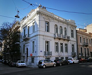
The Swedish Institute at Athens was founded in 1946 and is one of 19 foreign archaeological institutes operating in Athens, Greece. The Institute is one of three Swedish research institutes in the Mediterranean, along with the Swedish Institute of Classical Studies in Rome and the Swedish Research Institute in Istanbul. Besides the premises in Athens the institute has an office in Stockholm and a guesthouse in Kavala. It also owns the Nordic Library along with the Danish Institute at Athens, the Finnish Institute at Athens and the Norwegian Institute at Athens.
Kayalıpınar, a hamlet in the Sivas Province, Turkey, is a Hittite archaeological site, under excavation since 2004. It is identified with the ancient Samuha settlement.

Monkodonja is a hillfort occupied about 1850/1750-1500/1450 BC during the Bronze Age, located near the city of Rovinj in the Croatian region of Istria.
Kaman-Kalehöyük is a multi-period archaeological site in Kırşehir Province, Turkey, around 100 km south east of Ankara, 6 km east of the town center of Kaman. It is a tell or mound site that was occupied during the Bronze Age, Iron Age and Ottoman periods. Excavations in the mound have been carried out since 1986 under the direction of Sachihiro Omura, on behalf of the Middle Eastern Culture Center in Japan and the Japanese Anatolian Archeology Institute. The distance to Hattusa, the Hittite capital, is about 100km.
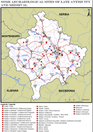
Part of series of articles upon Archaeology of Kosovo
Part of series of articles upon Archaeology of Kosovo
The archaeological sites Randlev and Hesselbjerg refer to two closely related excavations done throughout the 20th century near the village of Randlev in the Odder Municipality of Denmark, three kilometers southeast of the town of Odder. Randlev is known primarily for its Romanesque church constructed sometime around 1100 A.D. Hesselbjerg refers to the large Viking-Age cemetery discovered on the Hesselbjerg family farm and the site Randlev refers to the nearby settlement from the same period. Although both Randlev and Hesselbjerg were contemporaneous and encompass a similar area, Hesselbjerg refers more specifically to the 104 graves discovered prior to the later excavation at the site Randlev, which pertains to the Viking Age settlement. The settlement consisted of a farm complex that was likely active during the ninth and tenth centuries; finds from the site such as silver hoards and elaborate jewelry indicate that the farm was likely prosperous, a conjecture which is supported by the extremely fertile land surrounding the area. Artifacts were found in the vicinity of the Hesselbjerg and Randlev sites as early as 1932 when a local farmer discovered a silver hoard, but serious excavations were not conducted until 1963. These excavations ended in 1970; however, Moesgård Museum returned to the site in 1997 and continued analysis until 2010.

Gird-î Qalrakh is a tell, or archaeological settlement mound, in the Shahrizor Plain in Iraqi Kurdistan, Iraq. The archaeological site covers an area of 3 hectares according to the excavators; a geomagnetic survey indicated a size of 15 ha. At 26m high, Gird-î Qalrakh has been described as one of the highest mounds in the Shahrizor Plain. Excavations have been carried out in 2016, 2017 and 2019 by a team from the Goethe University Frankfurt. This research showed that the site has been almost continuously occupied from the third millennium BC into the Islamic period. Important discoveries include a substantial stone-built wall from the Neo-Assyrian period, and a well-preserved loom from the Sassanian period. Together with the numerous seals that have been discovered, this suggests that textile production may have been important at Gird-î Qalrakh during this period.
Karen Radner is an Austrian Assyriologist, the Alexander von Humboldt Professor of Ancient History at the University of Munich.
The post-imperial period was the final stage of ancient Assyrian history, covering the history of the Assyrian heartland from the fall of the Neo-Assyrian Empire in 609 BC to the final sack and destruction of Assur, Assyria's ancient religious capital, by the Sasanian Empire c. AD 240. There was no independent Assyrian state during this time, with Assur and other Assyrian cities instead falling under the control of the successive Median, Neo-Babylonian, Achaemenid, Seleucid and Parthian empires. The period was marked by the continuance of ancient Assyrian culture, traditions and religion, despite the lack of an Assyrian kingdom. The ancient Assyrian dialect of the Akkadian language went extinct however, completely replaced by Aramaic by the 5th century BC.
Tell Hazna I is a Syrian archaeological site located in al-Hasakah, to the north east of Al-Hasakah, inhabited during the Early Dynastic I–II Periods, and Uruk and Ubaid periods.

Kurd Qaburstan, is an ancient Near East archaeological site in Erbil Governorate, in the Kurdistan Region of Iraq, It is considered one of the most important The archaeological hills in Erbil 22 kilometers southwest of Erbil. It lies halfway between the Upper and Lower Zab rivers. The modern village of Yedi Kizlar covers to southeastern part of the lower town. The site dates back to the late 3rd millennium BC but was primarily occupied during the first half of the 2nd millennium, in the Old Babylonian and Mitanni periods. It has been suggested as the site of the ancient city of Qabra. Nearby promising excavations are at Tell Baqrta and Qasr Shemamok (Kilizi).