
This is a list of the extreme points of Azerbaijan, the points that are farther north, south, east or west than any other location.
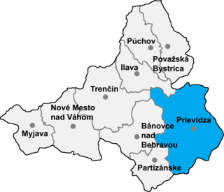
Nitrianske Rudno is a village and municipality in Prievidza District in the Trenčín Region of western Slovakia.

Csikéria is a village in Bács-Kiskun county, in the Southern Great Plain region of Hungary.

Imrehegy is a village in Bács-Kiskun county, in the Southern Great Plain region of southern Hungary.

Kötegyán is a village in Békés County, in the Southern Great Plain region of south-east Hungary.

Mártély is a village in Csongrád county, in the Southern Great Plain region of southern Hungary.

The Iori is a river in the South Caucasus that originates in the Greater Caucasus Mountains in eastern Georgia and continues in Azerbaijan, where it is also known as Gabirry (Qabirry) and flows into the Mingachevir reservoir. It is 320 kilometres (200 mi) long. It starts in the mountains north of Tbilisi, flows south toward that city, swings east and flows through the lowlands parallel to and between the Alazani River (north) and the Kura River (south).
Gənclər is a village and municipality in the Quba Rayon of Azerbaijan. It has a population of 328.

Borikovo is a village in the municipality of Smolyan, located in the Smolyan Province of southern Bulgaria. The village covers an area of 22.267 km² and is located 171.2 km from Sofia. As of 2007, the village had a population of 46 people.
Bukata is a village in the municipality of Smolyan, located in the Smolyan Province of southern Bulgaria. The village covers an area of 7.63 km² and is located 171.46 km from Sofia. As of 2007, the village had a population of 82 people.
Bukatsite is a village in the municipality of Smolyan, located in the Smolyan Province of southern Bulgaria. The village covers an area of 10.048 km² and is located 171.46 km from Sofia. As of 2007, the village had a population of 44 people.
Divino das Laranjeiras is a municipality in the state of Minas Gerais in the Southeast region of Brazil.
Kirtachi is a village and rural commune in Niger.
Alsószenterzsébet is a village in Zala County, Hungary.
Belsősárd is a village in Zala County, Hungary.
Nagyrécse is a village in Zala County, Hungary.

Rédics is a village in Zala County, Hungary.

Rosalie is an unincorporated community in Jackson County, Alabama, United States. On November 30, 2016, a devastating tornado struck the area.
Lnozavod is the name of several rural localities in Russia.


