
Ajdabiya is a former district of Libya. It lay in the northeastern part of the country. Its capital was Ajdabiya. As of 2007, it was subsumed within the enlarged Al Wahat District.

Zlitan was one of the municipalities (baladiyah) of Libya from 1983 to 1995. It lay in the northwestern part of the country, on the Mediterranean coast. In 1995 most of the municipality was included as part of Misrata District, where it remains as of 2009.
Bishr ibn al-Ḥārith better known as Bishr al-Ḥāfī was a Muslim saint born near Merv in about 767 C.E. He converted and studied Muslim tradition under Al-Fozail ibn Iyaz. Bishr became famous as one of the greatest saints in the area.
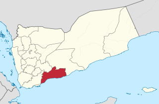
Abyan is a governorate of Yemen. The Abyan region was historically part of the Fadhli Sultanate. It was a base to the Aden-Abyan Islamic Army militant group. Its capital is the city of Zinjibar. This governorate is noted for its agriculture, in particular the cultivation of date palms and animal husbandry.
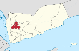
Sanaa, also spelled San'a' or Sana, is a governorate of Yemen. Its capital is Sanaa, which is also the national capital. However, the city of Sanaa is not part of the governorate but instead forms the separate governorate of Amanat Al-Asemah. The Governorate covers an area of 13,850 km2 (5,350 sq mi). As of 2004, the population was 2,918,379 inhabitants. Within this place is Jabal An-Nabi Shu'ayb or Jabal Hadhur, the highest mountain in the nation and the Arabian Peninsula.
The Battle of Al-Safra took place in late 1811, when Tusun Pasha's forces engaged with Saudi forces led by Saud bin Abdulaziz. It was a resounding Saudi victory against the Ottoman forces.

Montaza is the name of both a district and a park in Alexandria, Egypt. The district includes the park, but the two are legally distinct.
Ras Lanuf is a Mediterranean town in northern Libya, on the Gulf of Sidra in Tripolitania. The town is also home to the Ra's Lanuf Refinery, completed in 1984, with a crude oil refining capacity of 220,000 bbl/d (35,000 m3/d). The oil refinery is operated by the Ra's Lanuf Oil & Gas Processing Company, a subsidiary of the state-owned National Oil Corporation. Additionally, the city houses the Ra's Lanuf petrochemical complex – a major oil terminal – and oil pipelines: the Amal–Ra's Lanuf, the Messla–Ra's Lanuf, and the Defa-Ra's Lanuf pipeline.

Qaryat ʽUmar al Mukhtar is a village in the District of Jabal al Akhdar in north-eastern Libya. It was named after the Libyan resistance leader Omar Mukhtar. Under the Italian rule it was known as Mameli after the Italian patriot Goffredo Mameli.
Bin Jawad District, was one of the districts (baladiyah) of Libya from 1983 to 1987. It lay in the northern part of the country bordering the Gulf of Sidra. Its capital was Bin Jawad. Under Italy it was in Misrata Province. Before being made a baladiyah in 1983, it was part of the governorate system. In 1987 the area was incorporated into Sirte District and has remained there since.
Thirteen ancient towns have been discovered in Saudi Arabia up to the present day. These include Qaryat al-Fāw, the Al-Ukhdūd archeological area, Hegra, Jubbah, Tārūt, Al-Shuwayḥaṭiyah, Thāj, Taimaa and Dūmat Al-Jandal. There are still more ancient towns in Saudi Arabia, but little information is currently available on them. Saudi Arabia occupies a unique and distinctive geographic location, bridging civilizations between continents. In ancient times the Arabian peninsula served as a corridor for trade; therefore it saw the beginning of many civilizations, the relics of which are still evident today. The Saudi government has recently established the Saudi Commission for Tourism and Antiquities, which is responsible for the preservation of these cities.
Qaryat al-Qabil, often called simply al-Qaryah, is a village in Bani al-Harith District of Amanat al-Asimah Governorate, Yemen. It is the largest settlement in the Wadi Zahr area.

Sidi Bishr is a neighborhood in the Montaza District of Alexandria, Egypt. Established as a summering site by the Egyptian middle class before the Revolution of 1952, it has since become one of the largest neighborhoods of the city.

Al-Ba'aj District is a district in Nineveh Governorate, Iraq. Its administrative center is the city of Al-Ba'aj. Other settlements include Qaryat al-Sakar and Al-Jughaifi. The district is predominantly Sunni Arab.

Al-Shirqat District is a district of Saladin Governorate, Iraq. The district's capital is the town of Al-Shirqat. Other settlements include Khanugiyah, Mukhayim, Qaryat al Ḩūrīyah al Jadīdah, Al-Khadraniyah, Aynah, Ijamasa, and Jamaf. The ancient site of Assur is also located in the district.
Qaryat al-Ulya is a city located in the north-east of the Eastern Province, Saudi Arabia, specifically in the historic aṣ-Ṣummān area, which consists of more than 30 villages; Qaryat al-Ulya is the capital of this region. The whole Summan area includes a population of more than 50,000 people, 80% of them Saudis, according to the 2011 census. They maintain an agricultural area with more than two thousand wheat farms, which ranks it first in Saudi Arabian wheat production.
Al-Ḥujayjah, also known as Safīyah bint Thaʻlabah al-Shaybānīyah was a pre-Islamic poet of the Banū Shaybān tribe, noted for her work in the genre of taḥrīḍ. Her dates of birth and death are unknown, and even her historicity is open to question. But she seems to have granted protection to al-Ḥurqah bint al-Nuʻmān when Khosrow II demanded her in marriage from her father al-Nu'man III ibn al-Mundhir around the beginning of the seventh century, and her surviving corpus relates to the Battle of Dhū-Qār in c. 609. Characterised as a 'warrior diplomat', she has been read as a key figure in pre-Islamic poetry.
Qaryat al Ḩūrīyah al Jadīdah is a village in Al-Shirqat District, Saladin Governorate, Iraq. It is located west of River Tigris and north of the town of Al-Shirqat. By 2016, it was under control of Islamic State of Iraq and the Levant.

Qaryat Al Faw was the capital of the first Kindah kingdom. It is located about 100 km south of Wadi ad-Dawasir, and about 700 km southwest of Riyadh, the capital city of Saudi Arabia. The Al Faw archeological site reveals various features such as residential houses, markets, roads, cemeteries, temples, and water wells.
Qaryat Āl Sahlān is a village by the Euphrates river, located in Al-Hilla District, Babil Governorate, in central Iraq, about 20 km southwest of the main city Al Hillah.
