
Baghdad is the capital and largest city of Iraq. Situated on the Tigris, it is part of the Baghdad Governorate and is located near the Diyala River. With a population variously estimated at 6 or over 7 million, Baghdad forms 22% of Iraq's total population. In comparison to its large population, the city has a small area at just 673 square kilometers. It is the second-largest city in the Arab world after Cairo, and the second-largest city in West Asia after Tehran. Baghdad is historically known as a global cultural hub.

Cairo is the capital of Egypt and the Cairo Governorate, and is the country's largest city, being home to more than 10 million people. It is also part of the largest urban agglomeration in Africa, the Arab world and the Middle East. The Greater Cairo metropolitan area is the 12th-largest in the world by population with over 22.1 million people.

Beirut is the capital and largest city of Lebanon. As of 2014, Greater Beirut has a population of 2.5 million, which makes it the fourth-largest city in the Levant region and the seventeenth-largest in the Arab world. The city is situated on a peninsula at the midpoint of Lebanon's Mediterranean coast. Beirut has been inhabited for more than 5,000 years, making it one of the oldest cities in the world.

Riyadh is the capital and largest city of Saudi Arabia. It is also the capital of the Riyadh Province and the centre of the Riyadh Governorate. The current form of the metropolis emerged as an offshoot of the eponymous walled town following the dismantling of its defensive fortifications in the 1950s, after which the city underwent several phases of expansion and urbanization.

Muscat is the capital and most populated city in Oman. It is the seat of the Governorate of Muscat. According to the National Centre for Statistics and Information (NCSI), the total population of Muscat Governorate was 1.72 million as of September 2022. The metropolitan area spans approximately 3,500 km2 (1,400 sq mi) and includes six provinces called wilayats, making it the largest city in the Arabian Peninsula by area. Known since the early 1st century AD as an important trading port between the west and the east, Muscat was ruled by various indigenous tribes as well as foreign powers such as the Persians, the Portuguese Empire and the Ottoman Empire at various points in its history. A regional military power in the 18th century, Muscat's influence extended as far as East Africa and Zanzibar. As an important port-town in the Gulf of Oman, Muscat attracted foreign traders and settlers such as the Persians, Balochs and Sindhis. Since the accession of Qaboos bin Said as Sultan of Oman in 1970, Muscat has experienced rapid infrastructural development that has led to the growth of a vibrant economy and a multi-ethnic society. Muscat is termed as a Beta - Global City by the Globalization and World Cities Research Network.
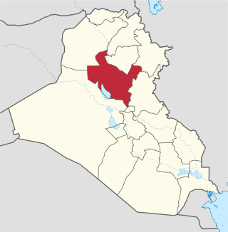
The Saladin, Salah ad Din, or Salah Al-Din Governorate is one of Iraq's 19 governorates, north of Baghdad. It has an area of 24,363 square kilometres (9,407 sq mi), with an estimated population of 1,042,200 people in 2003. It is made up of 8 districts, with the capital being Tikrit. Before 1976 the governorate was part of Baghdad Governorate.

Al Anbar Governorate, or Anbar Province, is the largest governorate in Iraq by area. Encompassing much of the country's western territory, it shares borders with Syria, Jordan, and Saudi Arabia. The population is mostly Sunni Arabs. The provincial capital is Ramadi; other important cities include Fallujah, Al-Qa'im and Haditha.

Ajdabiya is a former district of Libya. It lay in the northeastern part of the country. Its capital was Ajdabiya. As of 2007, it was subsumed within the enlarged Al Wahat District.

The 1964 United States House of Representatives elections was an election for the United States House of Representatives on November 3, 1964, to elect members to serve in the 89th United States Congress. They coincided with the election to a full term of President Lyndon B. Johnson. Johnson's landslide victory over Barry Goldwater allowed his Democratic Party to gain a net of 36 seats from the Republican Party, giving them a two-thirds majority in the House. The election also marked the first time since Reconstruction that Republicans made inroads in the Deep South, with Republicans winning seats in Georgia for the first time since 1874, and Alabama and Mississippi since 1876.

The 1882 United States House of Representatives elections were held for the most part on November 7, 1882, with five states holding theirs early between June and October. They occurred during President Chester A. Arthur's term. Elections were held for 325 seats of the United States House of Representatives, representing 38 states, to serve in the 48th United States Congress. They were the first elections after reapportionment following the 1880 United States census, increasing the size of the House. Special elections were also held throughout the year.
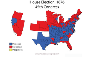
The 1876–77 United States House of Representatives elections were held on various dates in various states between June 5, 1876, and March 13, 1877. Each state set its own date for its elections to the House of Representatives before the first session of the 45th United States Congress convened on October 15, 1877. The size of the House increased to 293 seats with the addition of the new state of Colorado.
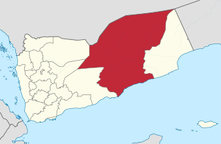
Hadhramaut Governorate is a governorate of Yemen. Lying within the large historical region of Hadhramaut, it is the country's largest governorate. The capital of Hadhramaut is the city of Mukalla. Other cities in Hadhramaut include the historical towns of Shibam, Sena, Seiyun, Tarim, and Ash Shihr.
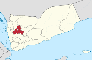
Sanaa, also spelled San'a' or Sana, is a governorate of Yemen. Its capital is Sanaa, which is also the national capital. However, the city of Sanaa is not part of the governorate but instead forms the separate governorate of Amanat Al-Asemah. The Governorate covers an area of 13,850 km2 (5,350 sq mi). As of 2004, the population was 2,918,379 inhabitants. Within this place is Jabal An-Nabi Shu'ayb or Jabal Hadhur, the highest mountain in the nation and the Arabian Peninsula.

Southern Lebanon is the area of Lebanon comprising the South Governorate and the Nabatiye Governorate. The two entities were divided from the same province in the early 1990s. The Rashaya and Western Beqaa districts, the southernmost districts of the Beqaa Governorate.

Iraq's 18 governorates are subdivided into 120 districts (kaza).

The 14 governorates of Syria, or muhafazat, are divided into 65 districts, or manatiq, including the city of Damascus. The districts are further divided into 281 subdistricts, or nawahi. Each district bears the same name as its district capital.

Sanaa, officially the Sanaa Municipality, is the capital and largest city of Yemen. The city is the capital of the Sanaa Governorate but is not part of the governorate as it forms a separate administrative unit. According to the Yemeni constitution, Sanaa is the capital of the country, although the seat of the Yemeni government moved to Aden, the former capital of South Yemen, in the aftermath of the Houthi occupation. Aden was declared the temporary capital by then-president Abdrabbuh Mansur Hadi in March 2015.
Jalu Municipality was one of the municipalities (baladiyah) of Libya, from 1983 to 1987. Its capital was Jalu.

The Battle of Mosul was a major battle initiated by the Iraqi Government forces with allied forces, the Kurdistan Regional Government, and international forces to retake the city of Mosul from the Islamic State (ISIL), which had seized the city years prior in June 2014. It was the largest conventional land battle since the capture of Baghdad in 2003. It was also the world's single largest military operation overall since the 2003 invasion of Iraq and was considered the toughest urban battle since World War II.
