Related Research Articles

The Vaal River is the largest tributary of the Orange River in South Africa. The river has its source near Breyten in Mpumalanga province, east of Johannesburg and about 30 kilometres (19 mi) north of Ermelo and only about 240 kilometres (150 mi) from the Indian Ocean. It then flows westwards to its confluence with the Orange River southwest of Kimberley in the Northern Cape. It is 1,458 kilometres (906 mi) long, and forms the border between Mpumalanga, Gauteng and North West Province on its north bank, and the Free State on its south.

Ladysmith is a city in the Uthukela District of KwaZulu-Natal, South Africa. It lies 230 kilometres (140 mi) north-west of Durban and 365 kilometres (227 mi) south-east of Johannesburg. Important industries in the area include food processing, textiles, and tyre production. Ladysmith is the seat for both the Alfred Duma Local Municipality and Uthukela District Municipality.

The Vaal Dam in South Africa was constructed in 1938 and lies 77 km south of OR Tambo International Airport, Johannesburg. The lake behind the dam wall has a surface area of about 320 square kilometres (120 sq mi) and is 47 meters deep. The Vaal Dam lies on the Vaal River, which is one of South Africa's strongest-flowing rivers. Other rivers flowing into the dam are the Wilge River, Klip River, Molspruit and Grootspruit. It has over 800 kilometres (500 mi) of shoreline and is South Africa's second biggest dam by area and the fourth largest by volume.

The siege of Ladysmith was a protracted engagement in the Second Boer War, taking place between 2 November 1899 and 28 February 1900 at Ladysmith, Natal.

The Queanbeyan River, a perennial stream that is part of the Molonglo catchment within the Murray–Darling basin, is located in the Monaro and Capital Country regions of New South Wales and the Australian Capital Territory, in Australia. The river is 104 kilometres (65 mi) in length with a catchment area of 96,000 hectares. The Queanbeyan River and the Cotter River meet the potable water supply needs of the Canberra and Queanbeyan region and whose water quality is specifically protected under Federal legislation.

The Gariep Dam is located in South Africa, near the town of Norvalspont, bordering the Free State and Eastern Cape provinces. Its primary purpose is for irrigation, domestic and industrial use as well as for power generation.

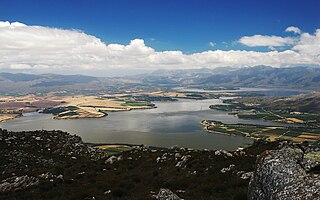
Windsor Dam was originally built to control flooding of Ladysmith, in KwaZulu-Natal by the Klip River, but silt buildup quickly reduced its efficiency. The Windsor Dam was commissioned in 1950, has a capacity of 772 cubic metres (27,300 cu ft), and a surface area of 0.826 square kilometres (0.319 sq mi), the dam wall is 17 metres (56 ft) high.

The N11 is a national route in South Africa which runs from the Botswana border at Groblersbrug, through Mokopane, Middelburg, Ermelo and Newcastle to end at the N3 just after Ladysmith.

Bospoort Dam is a gravity/earth-fill type dam on the Hex River, a tributary of the Elands River, part of the Crocodile River (Limpopo) basin. It is located near Rustenburg, North West, South Africa. Its primary purpose is for irrigation.
Driekloof Dam (Western Cape) is dam on the Klip River, Western Cape, South Africa. It was established in 1989.
Hellsgate Dam is a dam on the Klip River, near Uitenhage, Eastern Cape, South Africa. It was established in 1910.
Theewaterskloof Dam is an earth-fill type dam located on the Sonderend River near Villiersdorp, Western Cape, South Africa. Administratively it is located within Theewaterskloof Local Municipality. It was established in 1978 and is the largest dam in the Western Cape Water Supply System with a capacity of 480 million cubic metres, about 41% of the water storage capacity available to Cape Town, which has a population of over 4 million people. The dam mainly serves for municipal and industrial use as well as for irrigation purposes. The hazard potential of the dam has been ranked high (3).
Vaalharts Storage Weir is a dam in South Africa. It was established in 1936. Vaalhartz Weir is located on the Vaal River approximately 100 km downstream of Bloemhof Dam and 13 km upstream of Warrenton. The main purpose of the dam is to divert water from the Vaal River to the Olebogeng Mokoena Government Water Scheme as well as the Barkly Government Water Scheme. Water is also used for numerous small towns including Vryburg, Hartswater, Jan Kempdorp, Warrenton, Winsorton, Kipdam, Barkly West and Delportshoop.

Palmiet River is a river located in the Western Cape province of South Africa. The Palmiet River is a typical Western Cape river, experiencing winter rainfall and it is important for the Western Cape Water Supply System. It has a small catchment area of 500 km2, flows through the expanse of the Elgin Valley, and reaches the ocean through an estuary.
Slangdraai Dam is an earth-fill type dam located on the Sundays River near Ladysmith, KwaZulu-Natal, South Africa. It was established in 1986 and serves mainly for irrigation purposes. The hazard potential of the dam has been ranked significant (2).
The Vaal River Barrage Reservoir is a dam on the Vaal River near Vanderbijlpark, border Gauteng and Free State, South Africa.

The Klip River is the main river draining the portion of Johannesburg south of the Witwatersrand, and its basin includes the Johannesburg CBD and Soweto. The mouth of the river is at Vereeniging where it empties into the Vaal River, which is a tributary to the Orange River. Besides Vereeniging, other towns along the river include Henley on Klip, Lenasia and Meyerton.
Rand Water is a South African water utility that supplies potable water to the Gauteng province and other areas of the country and is the largest water utility in Africa. The water is drawn from numerous sources and is purified and supplied to industry, mining and local municipalities and is also involved in sanitation of waste water.

The Klip River is a main tributary of the Tugela River in KwaZulu-Natal, South Africa. The river originates on the west side of KwaZulu-Natal, initially flows eastward and then swings southward. It flows into the Windsor Dam, and then into the larger Qedusizi Dam before flowing east again. The river passes through Ladysmith before joining the Tugela River.
References
- ↑ van Vuuren, Lani (2012). In the Footsteps of Giants – Exploring the history of South Africa's large dams (PDF). Pretoria: Water Research Commission, South Africa. pp. 234–235. Retrieved 31 March 2022.
| Authority control databases: Geographic |
|---|
This article about a dam or floodgate in South Africa is a stub. You can help Wikipedia by expanding it. |