Quarterpath Road

Last updated

Quarterpath Road is one of the oldest roads in James City County and the independent city of Williamsburg, Virginia.

Contents

History

Colonial era

Established in the 17th century, Quarterpath Road extended from Middle Plantation (renamed Williamsburg in 1699) through what later became Kingsmill Plantation to Burwell's Landing on the James River, a few miles east of Jamestown. The Burwells were among the First Families of Virginia in the Colony of Virginia, and built the plantation's manor house beginning in the 1730s. A few years later, Carter Burwell built Carter's Grove immediately to the east in what became the modern day Grove Community.

For many years, the Quarterpath Road was the most direct route between Williamsburg and the landing on the James River at Burwell's which was east of Jamestown and more convenient to the Chesapeake Bay and the Atlantic Ocean. In 1775, as the hostilities which became the American Revolutionary War escalated, British troops loyal to the final Royal Governor, Lord Dunmore, walked along the road to steal gunpowder and munitions from the colony's stores at the Powder Magazine in Williamsburg. [1]

American Civil War

During the American Civil War (1861–1865), although he had personally hoped to avoid secession and a war for Virginia, James City County resident Benjamin S. Ewell, the president of the College of William and Mary, joined the local Virginia militia as the Board of Visitors closed the college during the War.

Colonel Ewell, an older brother of Confederate Major General Richard S. Ewell, was tasked with designing fortifications across the Virginia Peninsula east of Williamsburg which became known as the "Williamsburg Line". Under his guidance, 14 mostly earthen redoubts were planned and built, taking advantage of the terrain, and anchored by the earthen Fort Magruder at the junction of the roads to Williamsburg leading from Lee's Mill and Yorktown. Several of the redoubts to the southwest were located near (and west) of the Quarterpath Road and protected it.

In the 1862 Peninsula Campaign, Union forces commanded by Maj. Gen. George B. McClellan attempted to move northwesterly up the Peninsula from Fort Monroe and capture the Confederate capital of Richmond by circumventing the Confederate States Army in northern Virginia. Greatly outnumbered forces on the Peninsula initially under Major General John Bankhead Magruder delayed the advance through tactics which included elaborate ruses and physical barriers such as the Warwick Line (anchored by Mulberry Island and Yorktown), and the much less substantial Williamsburg Line. During the Battle of Williamsburg on May 5, 1862, nearly 41,000 Federals and 32,000 Confederates were engaged. Confederate casualties, including the cavalry skirmishing on May 4, were 1,682. Union casualties were 2,283. The area along the Quarterpath Road saw fierce fighting. Several of the redoubts still exist there, and have been preserved, as has a small portion of Fort Magruder along Penniman Road.

At the time, the Northern press portrayed the battle as a victory for the Federal army. McClellan mis-categorized it as a "brilliant victory" over superior forces. However, the defense of Williamsburg was seen by the South as a means of delaying the Federals, which allowed the bulk of the Confederate army to continue its withdrawal toward Richmond. (Benjamin Ewell's efforts to save and restore the college after the War became legendary in the U.S. Congress and the Williamsburg community).

Modern times

For much of the 20th century, most of the adjacent land to the Quarterpath Road was owned by the Colonial Williamsburg Foundation (CW). Under the leadership of CW Chairman Winthrop Rockefeller, a large tract was sold to Anheuser-Busch (AB) in the early 1970s for planned development. Among the goals were to complement Colonial Williamsburg attractions and enhance the local economy. The result was a large brewery, the Busch Gardens Williamsburg theme park, the Kingsmill planned resort community, and an office park. AB and related entities from that development plan now are the source of the area's largest employment base, surpassing both Colonial Williamsburg and the local military bases.

James City County

Although all of the Quarterpath Road was originally in James City County, Williamsburg became an independent city from the county in the late 19th century. Border adjustments through annexation have divided the roadway between these two local political subdivisions of Virginia.

The portion of the Quarterpath Road in James City County is now adjacent to and within the Kingsmill planned resort community. Near the intersection of Route 199, sections of the old Quarterpath Road and Carter's Grove Country Road each pass within sight of the county government complex, which is located on a heavily wooded site.

City of Williamsburg

With the city limits of Williamsburg, the section between U.S. Route 60 and State Route 199 still exists. Williamsburg's Quarterpath Park is located near the northern end, including a recreational center and a community swimming pool (however, the community center stopped operating the swimming pool in 2013.). [2] However, there will be no direct motor vehicle connection to new development areas because the city elected to close Quarterpath Road at Tutters Neck Pond and convert it to a walking and biking trail, with access to Redoubt Park commemorating the American Civil War history there. [1]

A shopping center is being developed along a portion near Route 199, with other development including a hospital complex under construction on the largest undeveloped tract of land in the city. Studies in the area began in 2005 as plans to utilize some of the large tract of undeveloped land were in exploratory stages. [3] According to the local Virginia Gazette newspaper, archaeologists working in 2008 found signs of a complex of dwellings they believe date to 1670, apparently a farm. Artifacts recovered from the site date from 1650 to 1750. Included were tobacco pipes and kitchen implements, fragments of wine glasses, and an array of tools. Although the site is only a short distance from the restored historic district known as Colonial Williamsburg, the researchers feel that the inhabitants probably had little communication with Williamsburg during its early days. Garrett R. Fesler, senior archaeologist on the project, told the newspaper: "It was probably oriented more toward the river. Tobacco was probably grown and hauled to the river for shipment. Later, when Williamsburg began to grow, the outlying farmer probably began to see it as a market." [4]

Related Research Articles

<span class="mw-page-title-main">Williamsburg, Virginia</span> Independent city in Virginia, United States

Williamsburg is an independent city in the Commonwealth of Virginia, United States. As of the 2020 census, it had a population of 15,425. Located on the Virginia Peninsula, Williamsburg is in the northern part of the Hampton Roads metropolitan area. It is bordered by James City County on the west and south and York County on the east.

<span class="mw-page-title-main">James City County, Virginia</span> County in Virginia, United States

James City County is a county located in the Commonwealth of Virginia. As of the 2020 census, the population was 78,254. Although politically separate from the county, the county seat is the adjacent independent city of Williamsburg.

<span class="mw-page-title-main">Virginia Peninsula</span> Peninsula in southeast Virginia, United States

The Virginia Peninsula is a peninsula in southeast Virginia, bounded by the York River, James River, Hampton Roads and Chesapeake Bay. It is sometimes known as the Lower Peninsula to distinguish it from two other peninsulas to the north, the Middle Peninsula and the Northern Neck.

<span class="mw-page-title-main">Colonial Williamsburg</span> Historic district of Williamsburg, Virginia, USA

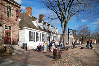
Colonial Williamsburg is a living-history museum and private foundation presenting a part of the historic district in the city of Williamsburg, Virginia. Its 301-acre (122 ha) historic area includes several hundred restored or recreated buildings from the 18th century, when the city was the capital of the Colony of Virginia; 17th-century, 19th-century, and Colonial Revival structures; and more recent reconstructions. The historic area includes three main thoroughfares and their connecting side streets that attempt to suggest the atmosphere and the circumstances of 18th-century Americans. Costumed employees work and dress as people did in the era, sometimes using colonial grammar and diction.

<span class="mw-page-title-main">Benjamin Stoddert Ewell</span>

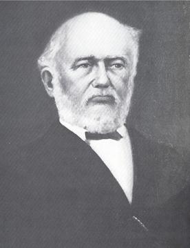
Benjamin Stoddert Ewell was a United States and Confederate army officer, civil engineer, and educator from James City County, Virginia. He graduated from the U.S. Military Academy at West Point, New York in 1832 and served as an officer and educator.

<span class="mw-page-title-main">Battle of Williamsburg</span> Battle of the American Civil War

The Battle of Williamsburg, also known as the Battle of Fort Magruder, took place on May 5, 1862, in York County, James City County, and Williamsburg, Virginia, as part of the Peninsula Campaign of the American Civil War. It was the first pitched battle of the Peninsula Campaign, in which nearly 41,000 Federals and 32,000 Confederates were engaged, fighting an inconclusive battle that ended with the Confederates continuing their withdrawal.

Magruder was a small unincorporated town in Virginia near Williamsburg in York County. Settled mostly by African-American freedmen after the American Civil War, it once had its own church, post office, cemetery, lodge, and homes. After this land was acquired for the development of the US military reservation known as Camp Peary, all the residents and businesses were displaced. Magruder is considered extinct and one of the lost towns of Virginia.

<span class="mw-page-title-main">Grove, Virginia</span> Human settlement in Virginia, United States of America

Grove is an unincorporated community in the southeastern portion of James City County in the Virginia Peninsula subregion of Virginia in the United States. It is located in the center of the Historic Triangle of Colonial Virginia, communities linked by the Colonial Parkway. This area is one of the busiest tourist destinations in the world.

<span class="mw-page-title-main">Lee Hall, Virginia</span> Neighborhood in Virginia, United States

Lee Hall is an unincorporated town located in the extreme western portion of the independent city of Newport News in the Commonwealth of Virginia in the United States.

<span class="mw-page-title-main">Fort Magruder</span>

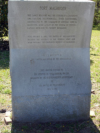
Fort Magruder was a 30-foot (9.1 m) high earthen fortification straddling the road between Yorktown and Williamsburg, Virginia, just outside the latter city during the American Civil War. At the center of the Williamsburg Line, it was also referred to as Redoubt Number 6.

<span class="mw-page-title-main">Carter's Grove</span> Historic plantation in Virginia, United States

Carter's Grove, also known as Carter's Grove Plantation, is a 750-acre (300 ha) plantation located on the north shore of the James River in the Grove Community of southeastern James City County in the Virginia Peninsula area of the Hampton Roads region of Virginia in the United States.

Kingsmill is a geographic area in James City County, Virginia, that includes a large planned residential community, a resort complex, a theme park, a brewery, and a commercial park.

Queen's Creek is located in York County in the Virginia Peninsula area of the Hampton Roads region of southeastern Virginia in the United States. From a point of origin near the Waller Mill Reservoir in western York County, it flows northeasterly across the northern half of the Peninsula as a tributary of the York River.

<span class="mw-page-title-main">History of Williamsburg, Virginia</span>

The history of Williamsburg, Virginia dates to the 17th Century. First named Middle Plantation, it changed its name to Williamsburg in 1699.

<span class="mw-page-title-main">Ewell, Virginia</span>

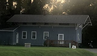
Ewell was an unincorporated town in James City County west of Williamsburg, in the U.S. state of Virginia.

<span class="mw-page-title-main">History of Hampton Roads</span>

The history of Hampton Roads dates to 1607, when Jamestown was founded. Two wars have taken place in addition to many other historical events.

<span class="mw-page-title-main">Burwell family of Virginia</span>

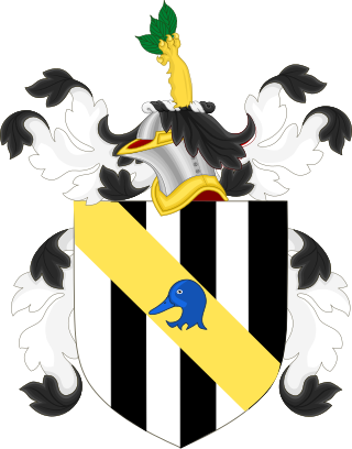
The Burwells were among the First Families of Virginia in the Colony of Virginia. John Quincy Adams once described the Burwells as typical Virginia aristocrats of their period: forthright, bland, somewhat imperious and politically simplistic by Adams' standards. In 1713, so many Burwells had intermarried with the Virginia political elite that Governor Spotswood complained that " the greater part of the present Council are related to the Family of Burwells...there will be no less than seven so near related that they will go off the Bench whenever a Cause of the Burwells come to be tried."

References

  1. 1 2 http://www.vagazette.com/news/local/va-news1_070908jul09,0,7697451.story%5B%5D
  2. City of Williamsburg : Parks & Recreation [ permanent dead link ]
  3. The James River Institute for Archaeology – Experience
  4. "Farm site predates city -- VAGazette.com". Archived from the original on June 13, 2008. Retrieved July 11, 2008.