Quartzite Mountain

Last updated

Quartzite Mountain is a summit in the U.S. state of Nevada. [1] The elevation is 7,762 feet (2,366 m). [1]

Summit A point on a surface that is higher in elevation than all points immediately adjacent to it, in topography

A summit is a point on a surface that is higher in elevation than all points immediately adjacent to it. The topographic terms acme, apex, peak, and zenith are synonymous.

U.S. state constituent political entity of the United States

In the United States, a state is a constituent political entity, of which there are currently 50. Bound together in a political union, each state holds governmental jurisdiction over a separate and defined geographic territory and shares its sovereignty with the federal government. Due to this shared sovereignty, Americans are citizens both of the federal republic and of the state in which they reside. State citizenship and residency are flexible, and no government approval is required to move between states, except for persons restricted by certain types of court orders. Four states use the term commonwealth rather than state in their full official names.

Nevada State of the United States of America

Nevada is a state in the Western United States. It is bordered by Oregon to the northwest, Idaho to the northeast, California to the west, Arizona to the southeast and Utah to the east. Nevada is the 7th most extensive, the 32nd most populous, but the 9th least densely populated of the U.S. states. Nearly three-quarters of Nevada's people live in Clark County, which contains the Las Vegas–Paradise metropolitan area where three of the state's four largest incorporated cities are located. Nevada's capital, however, is Carson City.

Quartzite Mountain was named for nearby quartzite deposits. [2]

Quartzite hard, non-foliated metamorphic rock which was originally pure quartz sandstone

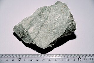
Quartzite is a hard, non-foliated metamorphic rock which was originally pure quartz sandstone. Sandstone is converted into quartzite through heating and pressure usually related to tectonic compression within orogenic belts. Pure quartzite is usually white to grey, though quartzites often occur in various shades of pink and red due to varying amounts of iron oxide (Fe2O3). Other colors, such as yellow, green, blue and orange, are due to other minerals.

Related Research Articles

Warm Springs, Nevada Place in Nevada, United States

Warm Springs is a former town in the Tonopah Basin in Nye County, Nevada, near the mountain pass which divides the Kawich and Hot Creek ranges. It is located at the junction of U.S. Route 6 and State Route 375, around 50 miles east of Tonopah. Only two abandoned buildings remain.

There are several lakes named Mud Lake within the U.S. state of Nevada.

Kings Mountain, California Unincorporated community in California, United States

Kings Mountain is an unincorporated community in San Mateo County, California, located along State Route 35 between Skeggs Point and Pise Mountain. This is about seven miles (11 km) north of Woodside Road (SR84). In the U.S. Geological Survey, National Geographic Names Database, the area is identified only as a geographic feature of type "summit" and not as a populated place. The community is inside area code 650 and uses the Woodside ZIP Code 94062.

Kapālama, now often called Pālama, is a neighborhood of Honolulu, Hawaii. It is often combined with the adjacent Kalihi and referred to as a single entity, Kalihi–Pālama.

Cactus Range

The Cactus Range is a small mountain range in Nye County, Nevada. The range lies southwest of Cactus Flat and north of Pahute Mesa. Goldfield lies 23 mi (37 km) to the west in Esmeralda County. The range lies within the restricted area of the Tonopah Test Range.

Prather, California Unincorporated community in California, United States

Prather is an unincorporated community in Fresno County, California. It is located 25 miles (40 km) northeast of Fresno, at an elevation of 1,657 ft (505 m). Prather has a population of 1,569.

Carrara, Nevada human settlement in Nevada, United States of America

Carrara is a ghost town in Nye County, Nevada. The townsite is located in the Amargosa Desert adjacent to US Route 95 about 8.5 miles southeast of Beatty. The old Tonopah and Tidewater Railroad line was about one half mile to the southwest. An old road, previously a railroad grade, runs straight for about 3 miles to the northeast up Carrara Canyon on the southeast flank of the Bare Mountains to an old marble quarry. The quarry is about 1400 feet higher in elevation than the townsite.

Rainier Mesa

Rainier Mesa is one of four major nuclear test regions within the Nevada National Security Site (NNSS). It occupies approximately 40 square miles (100 km2) along the northern edge of the NNSS and corresponds to Area 12.

Tongue Wash is a wash in Nye County, Nevada, in the United States.

Fairlawn is a ghost town in Elko County, in the U.S. state of Nevada.

Deep Gut Run is a stream in the U.S. state of West Virginia.

Funk Branch is a stream in Iron and Reynolds counties in the U.S. state of Missouri. It is a tributary of the Black River.

Hat Peak is a summit in the U.S. state of Nevada. The elevation is 5,886 feet (1,794 m).

Lime Mountain is a summit in the U.S. state of Nevada. The elevation is 6,936 feet (2,114 m).

Lone Mountain is a summit in the U.S. state of Nevada. The elevation is 7,864 feet (2,397 m).

National is an extinct town in Humboldt County, in the U.S. state of Nevada.

Johnnie is an extinct town in Nye County, in the U.S. state of Nevada. The GNIS classifies it as a populated place.

Oasis Mountain is a summit in the U.S. state of Nevada. The elevation is 4,728 feet (1,441 m).

Tolicha Peak is a summit in the U.S. state of Nevada. The elevation is 6,870 feet (2,090 m).

References