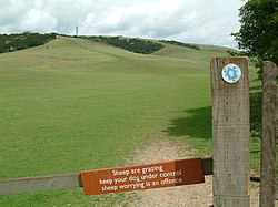
Queen Elizabeth Country Park is a large country park situated on the South Downs in southern England. It is located on the A3 road three miles south of Petersfield, Hampshire and lies within the South Downs National Park.
The park contains 1,400 acres (6 km2) of open access woodland and downland within the East Hampshire Area of Outstanding Natural Beauty, including Butser Hill (886 ft), the highest point on the South Downs, and War Down (801 ft). The woodland was mostly planted in the 1930s; it consists mainly of beech trees. [1] Several Long-distance footpaths run through the park including Staunton Way, Hangers Way and the South Downs Way bridleway. On a clear day the Isle of Wight can be seen from the top of Butser Hill.
The park also contains several waymarked and graded mountain biking trails. These are designed, built and maintained by volunteers.
The Queen Elizabeth Country Park parkrun takes place within the park each Saturday.
To the east of the forest, south of the village of Buriton lies the wooded hill of Head Down (205 m), which "is an area that caters for clubs that require land with privacy for outdoor recreational activities, such as archery or off-road vehicles." [2]
Every July the Queen Elizabeth Country Park is the start point for Oxfam's biggest annual fundraising event, Trailwalker UK. [3]
The Queen Elizabeth Country Park and the Queen Elizabeth National Park in Uganda are twinned in a project of "cultural exchange, mutual support and has its main emphasis on supporting Conservation through working closely with and empowering local communities". [4]
East Sussex is a ceremonial county in South East England. It is bordered by Kent to the north-east, West Sussex to the west, Surrey to the north-west, and the English Channel to the south. The largest settlement is the city of Brighton and Hove, and the county town is Lewes.
The South Downs Way is a long distance footpath and bridleway running along the South Downs in southern England. It is one of 16 National Trails in England and Wales. The trail runs for 160 km (100 mi) from Winchester in Hampshire to Eastbourne in East Sussex, with about 4,150 m (13,620 ft) of ascent and descent.
The South Downs are a range of chalk hills in the south-eastern coastal counties of England that extends for about 260 sq mi (670 km2) across the south-eastern coastal counties of England from the Itchen valley of Hampshire in the west to Beachy Head, in the Eastbourne Downland Estate, East Sussex, in the east. The Downs are bounded on the northern side by a steep escarpment, from whose crest there are extensive views northwards across the Weald. The South Downs National Park forms a much larger area than the chalk range of the South Downs, and includes large parts of the Weald.
The North Downs are a ridge of chalk hills in south east England that stretch from Farnham in Surrey to the White Cliffs of Dover in Kent. Much of the North Downs comprises two Areas of Outstanding Natural Beauty (AONBs): the Surrey Hills and the Kent Downs. The North Downs Way National Trail runs along the North Downs from Farnham to Dover.
The South Downs National Park is England's newest national park, designated on 31 March 2010. The park, covering an area of 1,627 square kilometres (628 sq mi) in southern England, stretches for 140 kilometres (87 mi) from Winchester in the west to Eastbourne in the east through the counties of Hampshire, West Sussex and East Sussex. The national park covers the chalk hills of the South Downs and a substantial part of a separate physiographic region, the western Weald, with its heavily wooded sandstone and clay hills and vales. The South Downs Way spans the entire length of the park and is the only National Trail that lies wholly within a national park.
Petersfield is a market town and civil parish in the East Hampshire district of Hampshire, England. It is 15 miles (24 km) north of Portsmouth. The town has its own railway station on the Portsmouth Direct line, the mainline rail link connecting Portsmouth and London. Situated below the northern slopes of the South Downs, Petersfield lies wholly within the South Downs National Park.
Butser Ancient Farm is an archaeological open-air museum and experimental archaeology site located near Petersfield in Hampshire, southern England. Butser features experimental reconstructions of prehistoric, Romano-British and Anglo-Saxon buildings. Examples of Neolithic dwellings, Iron Age roundhouses, a Romano-British villa and an early Saxon house are on display. The site is used as both a tourist attraction and a site for the undertaking of experimental archaeology. In this latter capacity, it was designed so that archaeologists could learn more about the agricultural and domestic economy in Britain during the millennium that lasted from circa 400 BCE to 400 CE, in what was the Late British Iron Age and Romano-British periods.
Butser Hill is a hill and nature reserve in Hampshire, England. South-west of Petersfield, it is a 239.7-hectare (592-acre) biological and geological Site of Special Scientific Interest. It is a national nature reserve and a Special Area of Conservation. Part of it is a Geological Conservation Review site and an area of 84.8 hectares is Oxenbourne Down, which is designated a Local Nature Reserve. Part of it is a Scheduled Monument.
Walbury Hill is a summit of the North Wessex Downs in Berkshire, England. With an elevation of 297 metres (974 ft), it is the highest natural point in South East England. On the hill's summit is the Iron Age hill fort of Walbury Camp, whilst the flanks of the hill lie within the Inkpen and Walbury Hills SSSI. The hill is one of three nationally important chalk wild grasslands in the North Wessex Downs, the others being in the Rushmore and Conholt Downs SSSI and the Hog's Hole SSSI. The summit of the hill is marked by a triangulation pillar, but lies on private land with no public access, although public access is available to the north of the summit via a byway.
Colden Common is a civil parish in the Winchester District of Hampshire, England, approximately 5 miles south of the city of Winchester, covering an area of 690.74 hectares (2.6670 sq mi) with a resident population of approximately 4,000 people. It includes the village of Colden Common and the hamlets of Hensting, Fisher's Pond, Nob's Crook, Highbridge and Brambridge. Part of the parish lies within the South Downs National Park.
Clanfield is a village and civil parish in the south-east of the East Hampshire district of Hampshire, England. It is situated 2.4 miles north of Horndean, 12 mi (19 km) north of Portsmouth and 6 mi (10 km) south of Petersfield. It sits to the west of the main A3 road, just north of where the A3(M) (Motorway) ends.
Buriton is a village and civil parish in the East Hampshire district of Hampshire, England. It is located 2 miles (3.3 km) south of Petersfield.
Beacon Hill, Warnford is a 46.4-hectare (115-acre) biological Site of Special Scientific Interest west of Warnford in Hampshire. It is a Nature Conservation Review site, and an area of 40.1 hectares is a national nature reserve. There is a round barrow cemetery dating to the Late Neolithic or Bronze Age on the hill, and this is a scheduled monument.
Sussex is a historic county and cultural region in the south of England corresponding roughly in area to the ancient Kingdom of Sussex. It is bounded on the north by Surrey, north-east by Kent, south by the English Channel, and west by Hampshire, and is divided for local government into West Sussex and East Sussex and the city of Brighton and Hove. The city of Brighton & Hove was created a unitary authority in 1997, and was granted City status in 2000. Until then Chichester had been Sussex's only city. By convention, Chichester is Sussex's capital city and Lewes is Sussex's county town.
Windmill Hill is a chalk hill running alongside the A3(M) in the East Hampshire district of Hampshire, England, overlooking Chalton to the east, and Clanfield to the west. It measures 193 metres above sea level and is named so because of Chalton Windmill which sits upon its summit. This windmill is a Grade II listed building which lay derelict until the late 1970s, when it was restored and converted into a private residence.
At 244 metres (801 ft), War Down is one of the highest hills in the county of Hampshire, England and the second highest summit in the Hampshire part of the South Downs. Just 1 kilometre to the northwest is the South Downs' highest point at Butser Hill.
Head Down is one of the highest points in the county of Hampshire, England, and in the South Downs, rising to 205 metres (673 ft) above sea level.
Oakham Hill is one of the highest points in the county of Hampshire, England, and in the South Downs, rising to 202 metres (663 ft) above sea level.
Oxenbourne Down, Clanfield is a 84.8-hectare (210-acre) Local Nature Reserve north of Clanfield in Hampshire. It is owned and managed by Hampshire County Council. It is part of Butser Hill, which is a Special Area of Conservation and Site of Special Scientific Interest.
50°57′57″N0°58′34″W / 50.96593°N 0.97606°W