
The 1960 Valdivia earthquake or the Great Chilean earthquake of 22 May is the most powerful earthquake ever recorded. Various studies have placed it at 9.4–9.6 on the moment magnitude scale. It occurred in the afternoon, and lasted approximately 10 minutes. The resulting tsunami affected southern Chile, Hawaii, Japan, the Philippines, eastern New Zealand, southeast Australia and the Aleutian Islands.

The Aconcagua River is a river in Chile that rises from the conflux of two minor tributary rivers at 1,430 metres (4,690 ft) above sea level in the Andes, Juncal River from the east and Blanco River from the south east. The Aconcagua river flows westward through the broad Aconcagua valley and enters the Pacific Ocean near the city of Concon, 20 kilometres (12 mi) north of Valparaíso.

Los Ángeles is the capital of the province of Bío Bío, in the commune of the same name, in Bío Bío, in the center-south of Chile. It is located between the Laja and Biobío rivers. The population is 186,671 inhabitants. The municipality ("comuna") of Los Ángeles has the highest absolute rural population of any Chilean municipality.

The Futaleufú River, located in northern Patagonia, is one of the premier whitewater rivers in the world. The river is fed by glacial snow melt in the Andean lakes region of Argentina and Chile. The river gorge drops as low as 1,700 metres (5,600 ft) below the surrounding glaciated peaks. The name Futaleufú is an indigenous Mapuche word meaning "Big River.” Locals refer to the valley as "un paisaje pintado por dios"—a landscape painted by God.

Arauco Province is one of four provinces of the Chilean region of Bío Bío (VIII). It spans a coastal area of 6,366 km2 (2,458 sq mi) just south of the mouth of the Biobío River, the traditional demarcation between the nation's major natural regions, Zona Central and Zona Sur. The province originally covered the once-independent indigenous territory of Araucanía, but this was afterward divided into four provinces. It is devoted largely to agricultural pursuits. The capital Lebu is situated on the coast about 90 km (56 mi) south of Concepción with which it is connected by rail.
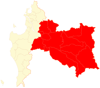
Biobío Province is one of four provinces of the Chilean region of Biobío (VIII). Its capital is Los Ángeles. It is bounded on the north, west and south by the provinces of Concepción, Arauco and Malleco, respectively, and on the east by Argentina. It has an area of 14,987.9 km2 (5,787 sq mi) of well-wooded and mountainous country, and exports timber to a large extent. The population is 373,981 according to the census of 2012.
Mulchén is a city and commune in Bío Bío Province of Bío Bío Region, Chile. It was first settled in 1871 by soldiers during the so-called Pacification of the Araucania. In 1875 Mulchén was officially founded.

The lake known as O'Higgins in Chile and San Martín in Argentina is located around coordinates 48°50′S72°36′W in Patagonia, between the Aysén del General Carlos Ibáñez del Campo Region and the Santa Cruz Province.
General Bernardo O'Higgins Airport is an airport serving Chillán, a city in the Ñuble Province of Chile's Bío-Bío Region. The airport is 6 kilometres (3.7 mi) northeast of the city.

Lauca National Park is located in Chile's far north, in the Andean range. It encompasses an area of 1,379 km2 of altiplano and mountains, the latter consisting mainly of enormous volcanoes. Las Vicuñas National Reserve is its neighbour to the south. Both protected areas, along with Salar de Surire Natural Monument, form Lauca Biosphere Reserve. The park borders Sajama National Park in Bolivia.
Southern Chile is an informal geographic term for any place south of the capital city, Santiago, or south of Biobío River, the mouth of which is Concepción, about 300 kilometres (200 mi) south of Santiago. Generally cities like Temuco are considered to be located in the south despite being relatively close to the geographical center of Chile. This is mainly because mainland Chile ended in La Frontera until the occupation of Araucanía (1861–1883). Similarly, the Southern Chile wine region is close to the geographic center of the country, encompassing wine-growing areas in the Bío Bío Region and Araucanía Region.
Nacimiento is a Chilean city situated in the Bío Bío Province, Bío Bío Region, 550 km (342 mi) south of Santiago, and 104 km (65 mi) from the closest major city in the region, Concepción.

Pangue Hydroelectric Plant is a hydroelectric power station in Bío Bío Region, Chile. It lies west of Callaqui volcano at the confluence of the rivers Pangue and Huiri-Huiri. The plant uses water from the upper Bío Bío River and produces 467 megawatts (626,000 hp) of electricity. The plant was built by Endesa in 1996.

The Andalién River is a river in the province of Concepción, in the Bío Bío Region of Chile. It drains the western side of Chile's Cordillera de la Costa and has a total length of 42 kilometres (26 mi). It is one of the two rivers that bracket the city of Concepción.

Icalma Lake is a lake of glacial origin located in the Andes of the La Araucanía Region of Chile. A hamlet on the southern shore of the lake is also called Icalma. About 3 kilometres (1.9 mi) from the hamlet is Icalma Pass, 1,307 metres (4,288 ft) in elevation and on the border with Argentina. The pass is traversed by a road, unpaved in Chile in 2017 and sometimes impassable during the Southern Hemisphere winter due to heavy snows. Icalma Airport is located 9 kilometres (5.6 mi) northeast of the hamlet.
The Pico River is a binational river of Patagonian Argentina and Chile. It is a tributary of the Figueroa River which it enters near El Manzanito in Chile. The Pico Rivers arises at the confluence of the Río Tromencó and the Río de las Mulas in Tehuelches Department, Chubut Province, Argentina, about 5.5 kilometres (3.4 mi) east-southeast of the village of Río Pico and about 40 kilometres (25 mi) east of the Chilean border. The river was named in honour of the engineer Octavio Pico y Burgess (1837–1892), who headed the Boundary Commission that settled the border conflict between Argentina and Chile.
Atacalco Airport Spanish: Aeropuerto Atacalco, is a rural airstrip 10 kilometres (6.2 mi) southeast of Recinto (es), a community in the Bío Bío Region of Chile.
San Lorenzo Airport Spanish: Aeropuerto de San Lorenzo, is an airport 23 kilometres (14 mi) east of Quilleco, a small town in the Bío Bío Region of Chile. The airport is in the valley of the Duqueco River, near the hamlet of Duqueco. A penstock fed hydroelectric station is 1.6 kilometres (1 mi) east of the airport.
La Viña Airport Spanish: Aeropuerto La Viña, is an airstrip serving Guangualí (es), a village in the Coquimbo Region of Chile. The airstrip sits on a bluff above the Quilimarí River valley, 11 kilometres (6.8 mi) inland from the Pacific coast.
María Dolores Airport is an airport serving Los Ángeles, capital of Bío Bío Province in the Bío Bío Region of Chile.


