Quincy House (Boston)

Last updated
Quincy House
Quincy House ca1920.png
Quincy House (left), c. 1920. The clock tower marks the southeastern corner of the hotel.
Map of Boston and Cambridge.png
Red pog.svg
Location within Boston
General information
TypeHotel
Location Brattle Square
Boston, Massachusetts
United States
Coordinates 42°21′36″N71°03′31″W / 42.3600°N 71.0587°W / 42.3600; -71.0587
Openingc. 1819
Renovatedc. 1885
Demolished1935
Technical details
Floor count7
Floor area23,500 sq ft (2,180 m2) (approx.)
Other information
Seating capacity500 (approx.)
References
[1] [2]

The Quincy House was a hotel in downtown Boston, Massachusetts, United States.

Contents

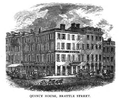
Located on the corner of Brattle Street and Brattle Square in the neighborhood of Scollay Square, it was in operation for most of the 19th and early 20th centuries. It was the largest hotel in Boston in the late 19th century, [3] and was a popular destination for prominent guests to the city. [4] It also served as a major headquarters for labor unions in Boston.

Quincy House was closed in 1929. The site is now occupied by City Hall Plaza, in front of Boston City Hall. [5]

History

The original Quincy House was built in the early 1800s, on the site of the first Quaker meeting house in Boston. [1] [3] The hotel was built with Quincy granite, making it the first building in Boston to be constructed with that material. [6] Over the course of the 19th century the hotel received several renovations and additions, the most extensive expansion occurring in c. 1885. [1] By the end of the 19th century, the building reached seven stories in height [7] and had approximately 500 rooms. [1]

By the late 1800s, the Quincy House acquired a reputation as one of the most famous hotels in the city. Labor unions in particular frequented the establishment; labor leaders and strike committees customarily held their meetings there. [8] The regular union presence at the Quincy House eventually resulted in the hotel advertising itself as the "official headquarters for organized labor" in the city. [9] The Quincy House additionally served as a popular place for local politicians, and it especially became known as the meeting place of the Board of Strategy, a group of high-ranking Democratic politicians (including P. J. Kennedy) who selected candidates for office and distributed patronage to party loyalists. [3] [10] [11]

The Quincy House's popularity began to suffer in the early 20th century; labor patronage declined during this period, [8] and the building was eclipsed by newer hotels in the city. [12] It was ultimately unable to recover from this downturn and closed on September 15, 1929. [13] The hotel remained vacant for several years, during which the Suffolk Savings Bank and the First National Bank of Boston each acquired separate parcels of the building. [2] In late 1934, the banks decided to raze the hotel, and in early 1935 it was demolished and replaced with a parking lot. [3] [8] [12] [14] The site is now occupied by City Hall Plaza, in front of Boston City Hall. [5]

Images

Related Research Articles

<span class="mw-page-title-main">Government Center, Boston</span> Area in downtown Boston, Massachusetts

Government Center is an area in downtown Boston, centered on City Hall Plaza. Formerly the site of Scollay Square, it is now the location of Boston City Hall, courthouses, state and federal office buildings, and a major MBTA subway station, also called Government Center. Its development was controversial, as the project displaced thousands of residents and razed several hundred homes and businesses.

<span class="mw-page-title-main">Faneuil Hall</span> United States historic place in Boston, MA (opened 1743)

Faneuil Hall is a marketplace and meeting hall located near the waterfront and today's Government Center, in Boston, Massachusetts. Opened in 1742, it was the site of several speeches by Samuel Adams, James Otis, and others encouraging independence from Great Britain. It is now part of Boston National Historical Park and a well-known stop on the Freedom Trail. It is sometimes referred to as "the Cradle of Liberty," though the building and location have ties to slavery.

<span class="mw-page-title-main">Government Center station (MBTA)</span> Subway station in Boston, Massachusetts, US

Government Center station is an MBTA subway station in Boston, Massachusetts. It is located at the intersection of Tremont, Court and Cambridge Streets in the Government Center area. It is a transfer point between the light rail Green Line and the rapid transit Blue Line. With the Green Line platform having opened in 1898, the station is the third-oldest operating subway station in the MBTA system; only Park Street and Boylston are older. The station previously served Scollay Square before its demolition for the creation of Boston City Hall Plaza.

<span class="mw-page-title-main">Post Office Square, Boston</span> Square in Boston in Massachusetts, United States

Post Office Square in Boston, Massachusetts is a square located in the financial district at the intersection of Milk, Congress, Pearl and Water Streets. It was named in 1874 after the United States Post Office and Sub-Treasury which fronted it, now replaced by the John W. McCormack Post Office and Courthouse.

<span class="mw-page-title-main">Scollay Square</span> Former public square in downtown Boston, Massachusetts

Scollay Square was a vibrant city square in downtown Boston, Massachusetts. It was named for William Scollay, a prominent local developer and militia officer who bought a landmark four-story merchant building at the intersection of the Cambridge and Court Streets in the year 1795. Local citizens began to refer to this intersection as Scollay's Square, and, in 1838, the city officially memorialized the intersection as the Scollay Square. Early on, the area was a busy center of commerce, including daguerreotypist (photographer) Josiah Johnson Hawes (1808–1901) and Dr. William Thomas Green Morton, the first dentist to use ether as an anaesthetic.

<span class="mw-page-title-main">Boston City Hall</span> City hall of Boston, Massachusetts since 1969

Boston City Hall is the seat of city government of Boston, Massachusetts. It includes the offices of the mayor of Boston and the Boston City Council. The current hall was built in 1968 to assume the functions of the Old City Hall.

<span class="mw-page-title-main">West End, Boston</span> Neighborhood of Boston in Suffolk, Massachusetts, United States

The West End is a neighborhood of Boston, Massachusetts, bounded generally by Cambridge Street to the south, the Charles River to the west and northwest, North Washington Street on the north and northeast, and New Sudbury Street on the east. Beacon Hill is to the south, North Point is across the Charles River to the north, Kendall Square is across the Charles River to the west, and the North End is to the east. A late 1950s urban renewal project razed a large Italian and Jewish enclave and displaced over 20,000 people in order to redevelop much of the West End and part of the neighboring Downtown neighborhood. After that, the original West End became increasingly non-residential, including part of Government Center as well as much of Massachusetts General Hospital and several high rise office buildings. More recently, however, new residential buildings and spaces, as well as new parks, have been appearing across the West End.

<span class="mw-page-title-main">John F. Kennedy Federal Building</span> Building in Boston, Massachusetts

John Fitzgerald Kennedy Federal Building is a United States federal government office building located in the Government Center area of Boston, Massachusetts, adjacent to City Hall Plaza and diagonally across from Boston City Hall. An example of 1960s modern architecture, and designed by Walter Gropius and The Architects Collaborative with Samuel Glaser, it is a complex that consists of two offset 26-floor towers that sit on-axis to each other and a low rise building of four floors that connects to the two towers through an enclosed glass corridor. The two towers stand at a height of 387 feet (118 m). The complex was built in 1963-1966. It was listed on the National Register of Historic Places in 2021.

<span class="mw-page-title-main">Court Street (Boston)</span> Street in Boston, Massachusetts, US

Court Street is located in the Financial District of Boston, Massachusetts. Prior to 1788, it was called Prison Lane (1634–1708) and then Queen Street (1708–1788). In the 19th century it extended beyond its current length, to Bowdoin Square. In the 1960s most of Court Street was demolished to make way for the construction of Government Center. The remaining street extends a few blocks, near the Old State House on State Street.

<span class="mw-page-title-main">Brattle Street (Boston)</span> Former street in Boston from 1694 to 1962

Brattle Street, which existed from 1694 to 1962, was a street in Boston, Massachusetts located on the current site of City Hall Plaza, at Government Center.

<span class="mw-page-title-main">Provident Institution for Savings in the Town of Boston</span>

The Provident Institution for Savings (est.1816) in Boston, Massachusetts, was the first chartered savings bank in the United States. James Savage and others founded the bank on the belief that "savings banks would enable the less fortunate classes of society to better themselves in a manner which would avoid the dangers of moral corruption traditionally associated with outright charitable institutions."

<span class="mw-page-title-main">Pemberton Square</span>

Pemberton Square in the Government Center area of Boston, Massachusetts, was developed by P.T. Jackson in the 1830s as an architecturally uniform mixed-use enclave surrounding a small park. In the mid-19th century both private residences and businesses dwelt there. The construction in 1885 of the massive John Adams Courthouse changed the scale and character of the square, as did the Center Plaza building in the 1960s.

<span class="mw-page-title-main">Cornhill, Boston</span> Street in Boston, Massachusetts, US

Cornhill was a street in Boston, Massachusetts, in the 18th, 19th and 20th centuries, located on the site of the current City Hall Plaza in Government Center. It was named in 1829; previously it was known as Market Street (1807–1828). In its time, it comprised a busy part of the city near Brattle Street, Court Street and Scollay Square. In the 19th century, it was the home of many bookstores and publishing companies. As of 1969, Cornhill exists as 144 feet along the edge of City Hall Plaza.

<span class="mw-page-title-main">Tremont Row</span>

Tremont Row (1830s-1920s) in Boston, Massachusetts, was a short street that flourished in the 19th and early-20th centuries. It was located near the intersection of Court, Tremont, and Cambridge streets, in today's Government Center area. It existed until the 1920s, when it became known as Scollay Square. In 1859 the Barre Gazette newspaper described Tremont Row as "the great Dry Goods Street of Boston."

<span class="mw-page-title-main">American House (Boston)</span> Hotel in Massachusetts, United States

The American House was a hotel in Boston, Massachusetts, located on Hanover Street. Abraham W. Brigham, Lewis Rice (1837–1874), Henry B. Rice (1868–1888), and Allen E. Jones served as proprietors. In 1851 the building was expanded, to a design by Charles A. Alexander. In 1868 it had "the first hotel passenger elevator in Boston." By the 1860s it also had "billiard halls, telegraph office, and cafe." In the late 19th century it was described as "the headquarters of the shoe-and-leather trade" in the city. Guests of the hotel and restaurant included John Brown, Ralph Waldo Emerson, William Whitwell Greenough, Charles Savage Homer, Zadoc Long, and George Presbury Rowell. Many groups held meetings there, among them: Granite Cutters' International Association of America, Letter Carriers' Association, National Electric Light Association, and New England Shorthand Reporters' Association. The hotel closed in 1916, and re-opened under new management in 1918. It permanently closed on August 8, 1935, and the building was shortly afterwards demolished to make room for a parking lot. The John F. Kennedy Federal Building now occupies the site.

<span class="mw-page-title-main">Crawford House (Boston, Massachusetts)</span> Hotel in Massachusetts, United States

The Crawford House was a hotel and restaurant in downtown Boston, Massachusetts. Located on Court and Brattle Streets in Scollay Square, it was in operation during the late nineteenth and early twentieth centuries, and was for a time among the leading hotels in the city. The building was demolished in 1962 as part of the Government Center project.

<span class="mw-page-title-main">Adams Square station</span> Former streetcar station in Boston, Massachusetts

Adams Square was an underground streetcar station located at Adams Square in downtown Boston, Massachusetts. It opened in 1898 and was used until 1963.

<span class="mw-page-title-main">Adams Square (Boston)</span>

Adams Square (1879–1963) was a square in downtown Boston, Massachusetts. Now demolished, it was formerly located on the site of the current Boston City Hall in Government Center.

<span class="mw-page-title-main">Norfolk House (Dedham, Massachusetts)</span> 1801 building in Dedham, Massachusetts

The Norfolk House also known as the Norfolk Hotel, was a tavern in Dedham, Massachusetts originally built in 1801 and located at 19 Court Street. It hosted John Quincy Adams, Andrew Jackson, and the Marquis de Lafayette.

<span class="mw-page-title-main">Architecture of Boston</span> Overview of the architecture in Boston, Massachusetts

The architecture of Boston is a robust combination of old and new architecture. As one of the oldest cities in North America, Boston, Massachusetts has accumulated buildings and structures ranging from the 17th-century to the present day, having evolved from a small port town to a large cosmopolitan center for education, industry, finance, and technology. The city is known for its granite buildings stemming from its early days. It is also known for being one of the origins of Federal Architecture.

References

  1. 1 2 3 4 Ellis, George E. Bacon's Dictionary of Boston. Boston: Houghton, Mifflin & Co., 1886. pp. 341-42.
  2. 1 2 "Banks Soon to Decide on Quincy House Disposition." Boston Daily Globe. 27 December 1934: p. 7.
  3. 1 2 3 4 "Mayor Couldn't Get Into Quincy House." Boston Daily Globe. 19 September 1956: p. 36.
  4. "Quincy House Front is Sold." Boston Daily Globe. 10 October 1924: p. 28A.
  5. 1 2 Sammarco, Anthony Michael. Boston: A Century of Progress. Charleston, SC: Arcadia Publishing, 1995. ISBN   0-7385-3876-0. p. 28.
  6. Kruh, David. Always Something Doing: Boston's Infamous Scollay Square. Rev. ed. Boston: Northeastern University Press, 1999. ISBN   1-55553-410-4. p. 24.
  7. "Necrology." New England Magazine and Bay State Monthly Nov. 1886: 287-91. p. 290
  8. 1 2 3 "Third Quincy House Blaze in 48 Hours." Boston Daily Globe. 22 January 1935: p. 3.
  9. The Quincy House. Advertisement. American Federationist Aug. 1918: 848.
  10. Nasaw, David. The Patriarch: The Remarkable Life and Turbulent Times of Joseph P. Kennedy. New York: The Penguin Press, 2012. ISBN   978-1-101-59591-6
  11. Davis, John H. The Kennedys: Dynasty and Disaster. New York: Shapolsky Publishers, 1992. ISBN   1-56171-060-1. p. 34
  12. 1 2 "Almost a Memory." Boston Daily Globe. 27 December 1934: p. 14.
  13. "Door is Locked at Quincy House." Boston Daily Globe. 16 September 1929: p. 1.
  14. "Boston Proper and Back Bay." Map. Atlas for the City of Boston. G. W. Bromley & Co., 1938. Web. 13 May 2013. (shows the Quincy House has been replaced by a parking lot)