Quioveo

Last updated
Map of the Gulf of Guinea, showing Sao Tome, Principe, and Annobon. Gulf of Guinea (English).jpg
Map of the Gulf of Guinea, showing São Tomé, Príncipe, and Annobón.
Map of Annobon showing the location of Quioveo on the island. Annobon.png
Map of Annobón showing the location of Quioveo on the island.

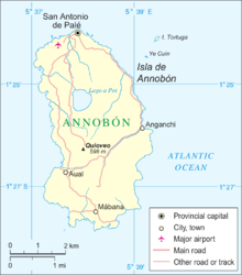
Quioveo is the extinct volcanic peak at the centre of the island of Annobón, Equatorial Guinea. It rises to a height of 598 metres. [1]

Annobón Province in San Antonio de Palé, Equatorial Guinea

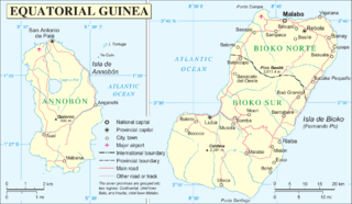
Annobón is a small province of Equatorial Guinea consisting of the island of Annobón and its associated islets in the Gulf of Guinea and Atlantic Ocean's Cameroon line. The provincial capital is San Antonio de Palé on the north side of the island; the other town is Mabana, formerly known as San Pedro. The roadstead is relatively safe, and some passing vessels take advantage of it in order to obtain water and fresh provisions, of which Annobon has offered an abundant supply. However, there is no regular shipping service to the rest of Equatorial Guinea, and ships call as infrequently as every few months. According to the 2015 census it had 5,232 inhabitants, a small population increase from the 5,008 registered by the 2001 census. The official language is Spanish but most of the inhabitants speak a creole form of Portuguese. The island's main industries are fishing and timbering.

Equatorial Guinea country in Africa

Equatorial Guinea, officially the Republic of Equatorial Guinea, is a country located on the west coast of Central Africa, with an area of 28,000 square kilometres (11,000 sq mi). Formerly the colony of Spanish Guinea, its post-independence name evokes its location near both the Equator and the Gulf of Guinea. Equatorial Guinea is the only sovereign African state in which Spanish is the official language. As of 2015, the country had an estimated population of 1,222,245.

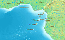
The island of Annobón is part of the Cameroon line of volcanoes, together with the islands of São Tomé Island, Príncipe, Bioko, and Mount Cameroon on the African mainland.

Cameroon line mountain range

The Cameroon line is a 1,600 km (990 mi) chain of volcanoes. It includes islands in the Gulf of Guinea and mountains that extend along the border region of eastern Nigeria and western Cameroon, from Mount Cameroon on the Gulf of Guinea north and east towards Lake Chad. The islands, which span the equator, have tropical climates and are home to many unique plant and bird species. The mainland mountain regions are much cooler than the surrounding lowlands, and also contain unique and ecologically important environments.

São Tomé Island island

São Tomé Island, at 854 km2 (330 sq mi), is the largest island of São Tomé and Príncipe and is home to about 157,000 or 96% of the nation's population. The island is divided into six districts. It is located 2 km north of the equator.

Príncipe island off of the coast of Africa

Príncipe is the smaller, northern major island of the country of São Tomé and Príncipe lying off the west coast of Africa in the Gulf of Guinea. It has an area of 136 square kilometres (53 sq mi) and a population of 7,324 (2012). The island is a heavily eroded volcano speculated to be over three million years old, surrounded by smaller islands including Ilheu Bom Bom, Ilhéu Caroço, Tinhosa Grande and Tinhosa Pequena. Part of the Cameroon Line archipelago, Príncipe rises in the south to 947 metres at Pico do Príncipe. The island is the main constituent of the Autonomous Region of Príncipe, established in 1995, and of the coterminous district of Pagué.

Related Research Articles

Geography of Equatorial Guinea

The Republic of Equatorial Guinea is located in west central Africa. Bioko Island lies about 40 kilometers (24.9 mi) from Cameroon. Annobón Island lies about 595 kilometres (370 mi) southwest of Bioko Island. The larger continental region of Rio Muni lies between Cameroon and Gabon on the mainland; it includes the islands of Corisco, Elobey Grande, Elobey Chico, and adjacent islets.

Gulf of Guinea The northeasternmost part of the tropical Atlantic Ocean between Cape Lopez in Gabon, north and west to Cape Palmas in Liberia

The Gulf of Guinea is the northeasternmost part of the tropical Atlantic Ocean between Cape Lopez in Gabon, north and west to Cape Palmas in Liberia. The intersection of the Equator and Prime Meridian is in the gulf.

Music of Equatorial Guinea

Equatorial Guinea's culture has been less documented than most African countries, and commercial recordings remain scarce.

The Annobonese is a Portuguese creole known to its speakers as Fa d'Ambu or Fá d'Ambô. It is spoken on the Annobón and Bioko Islands off the coast of Equatorial Guinea, mostly by people of mixed African, Portuguese and Spanish descent. It is called annobonense or annobonés in Spanish.

Corisco island

Corisco, or Mandj, is a small island of Equatorial Guinea, located 29 kilometres (18 mi) southwest of the Rio Muni estuary that defines the border with Gabon. Corisco, whose name derives from the Portuguese word for lightning, has an area of just 14 km2 (5 sq mi), and its highest point is 35 metres (115 ft) above sea level.

Fernão do Pó, also known as Fernão Pó, Fernando Pó or Fernando Poo, was a 15th-century Portuguese navigator and explorer of the West African coast. He discovered the islands in the Gulf of Guinea around 1472, one of which until the mid-1900s bore a version of his name, Fernando Pó or Fernando Poo. The island is now named Bioko and is part of Equatorial Guinea. His name had also been given to several other places in nearby Cameroon; the village of Fernando Pó, Portugal; and the village of Fernando Pó, Sierra Leone.

Discoclaoxylon is a plant genus of the family Euphorbiaceae, first described in 1914. It is native to western and central Africa, including islands in the Gulf of Guinea.

  1. Discoclaoxylon hexandrum(Müll.Arg.) Pax & K.Hoffm. - Ghana, Guinea, Ivory Coast, Sierra Leone, Nigeria, Cameroon, Gabon, Central African Republic, Equatorial Guinea, São Tomé, Congo-Brazzaville, Zaire, Uganda
  2. Discoclaoxylon occidentale(Müll.Arg.) Pax & K.Hoffm. - São Tomé
  3. Discoclaoxylon pedicellare(Müll.Arg.) Pax & K.Hoffm. - Bioko
  4. Discoclaoxylon pubescens(Pax & K.Hoffm.) Exell - Annobón
San Antonio de Palé Place in Annobón, Equatorial Guinea

San Antonio de Palé, formerly known as St Antony, San Antonio de Praia and Palea, is the capital of Annobón.

Pico Basilé mountain

Pico Basilé, located on the island of Bioko, is the tallest mountain of Equatorial Guinea. With an altitude of 9,878 ft, it is the summit of the largest and highest of three overlapping basaltic shield volcanoes which form the island. From the summit, Mt. Cameroon can be seen to the northeast. Pico Basilé lies close to the city of Malabo. The very top is used as a broadcast transmitting station for RTVGE and microwave relay station for various communication networks.

Articles related to Equatorial Guinea include:

The São Tomé, Príncipe, and Annobón moist lowland forests is a tropical moist broadleaf forest ecoregion that covers the islands of São Tomé and Príncipe, which form the island nation of São Tomé and Príncipe, as well as the island of Annobón, which is part of Equatorial Guinea.

Wildlife of São Tomé and Príncipe

The wildlife of São Tomé and Príncipe is composed of its flora and fauna. São Tomé and Príncipe are oceanic islands which have always been separate from mainland West Africa and so there is a relatively low diversity of species, restricted to those that have managed to cross the sea to the islands. However the level of endemism is high with many species occurring nowhere else in the world.

<i>Palisota</i> genus of plants

Palisota is a genus of plant in family Commelinaceae, first described in 1828. It is native to sub-Saharan Africa.

  1. Palisota alopecurusPellegr. - Cameroon, Gabon, Central African Republic, Congo-Brazzaville
  2. Palisota ambigua(P.Beauv.) C.B.Clarke - central Africa from Nigeria to Angola
  3. Palisota barteriHook.f. - western + central Africa
  4. Palisota bicolorMast. - Bioko
  5. Palisota bogneriBrenan - Gabon, Equatorial Guinea
  6. Palisota brachythyrsaMildbr. - Cameroon, Gabon, Central African Republic, Congo-Brazzaville, Zaïre
  7. Palisota bracteosaC.B.Clarke - western + central Africa; naturalized in Trinidad & Tobago
  8. Palisota congolanaHua - Congo-Brazzaville
  9. Palisota flagellifloraFaden - Cameroon
  10. Palisota graciliorMildbr. - Cameroon
  11. Palisota hirsuta(Thunb.) K.Schum. - western + central Africa
  12. Palisota lagopusMildbr. - Gabon, Central African Republic, Congo-Brazzaville, Equatorial Guinea
  13. Palisota laurentiiDe Wild. - Zaïre
  14. Palisota laxifloraC.B.Clarke - São Tomé, Annobon
  15. Palisota manniiC.B.Clarke - central Africa from Nigeria to Tanzania
  16. Palisota myrianthaK.Schum - Luanda region of Angola
  17. Palisota orientalisK.Schum. - Tanzania
  18. Palisota pedicellataK.Schum - São Tomé, Annobon
  19. Palisota preussianaK.Schum. ex C.B.Clarke - Bioko, Cameroon, Congo-Brazzaville
  20. Palisota pynaertiiDe Wild. - Zaïre
  21. Palisota satabieiBrenan - Cameroon, Gabon, Equatorial Guinea, Congo-Brazzaville
  22. Palisota schweinfurthiiC.B.Clarke - central Africa from Nigeria to Tanzania and south to Zambia
  23. Palisota tholloniHua - Cameroon, Gabon, Central African Republic, Congo-Brazzaville, Zaïre
  24. Palisota thyrsostachyaMildbr. - Zaïre
  25. Palisota waibeliiMildbr. - Cameroon

Thecacoris annobonae is a species of plant in the Phyllanthaceae family. It is found in Cameroon and Equatorial Guinea. Its natural habitat is subtropical or tropical moist lowland forests. It is threatened by habitat loss.

The Mount Cameroon and Bioko montane forests ecoregion, of the tropical and subtropical moist broadleaf forests Biome, are in Afromontane habitats in Cameroon and Equatorial Guinea of Africa.

Insular Region (Equatorial Guinea) Equatorial Guinea

The Insular Region of Equatorial Guinea comprises the former Spanish territory of Fernando Po, together with Annobón island, the latter formerly part of the Spanish territory of Elobey, Annobón and Corisco, which was located in the Gulf of Guinea and in the Corisco Bay.

References

  1. "Profile on geonames.org", accessed May 24, 2011.

Coordinates: 1°26′13″S5°37′59″E / 1.43694°S 5.63306°E / -1.43694; 5.63306

Geographic coordinate system Coordinate system

A geographic coordinate system is a coordinate system that enables every location on Earth to be specified by a set of numbers, letters or symbols. The coordinates are often chosen such that one of the numbers represents a vertical position and two or three of the numbers represent a horizontal position; alternatively, a geographic position may be expressed in a combined three-dimensional Cartesian vector. A common choice of coordinates is latitude, longitude and elevation. To specify a location on a plane requires a map projection.