

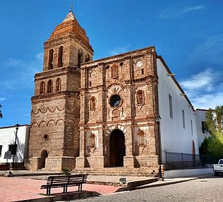
Quiriego is a small town and the county seat of the Municipality of Quiriego, located in the southeast of the Mexican state of Sonora.
Quiriego is a small town and the county seat of the Municipality of Quiriego, located in the southeast of the Mexican state of Sonora.
The Quiriego Municipality area is 2,705.72 km². The town is located at an elevation of 822 meters.
Quiriego is located east of Ciudad Obregón and is connected by dirt road with the main Federal Highway 15 at the village of Fundición. [1]
Neighboring municipalities are Rosario to the north, Álamos to the east, Navojoa and the state of Chihuahua to the south and Cajeme to the west.
| Climate data for Quiriego | |||||||||||||
|---|---|---|---|---|---|---|---|---|---|---|---|---|---|
| Month | Jan | Feb | Mar | Apr | May | Jun | Jul | Aug | Sep | Oct | Nov | Dec | Year |
| Average high °C (°F) | 25.6 (78.1) | 28 (82) | 29.7 (85.5) | 33.1 (91.6) | 35.3 (95.5) | 39.0 (102.2) | 36.8 (98.2) | 35.3 (95.5) | 35.4 (95.7) | 33.7 (92.7) | 30.2 (86.4) | 26.6 (79.9) | 32.4 (90.3) |
| Average low °C (°F) | 7.3 (45.1) | 7.5 (45.5) | 9 (48) | 11.4 (52.5) | 15.1 (59.2) | 20.9 (69.6) | 23.4 (74.1) | 23 (73) | 21.8 (71.2) | 16 (61) | 10.4 (50.7) | 7.0 (44.6) | 14.4 (57.9) |
| Average precipitation mm (inches) | 30 (1.2) | 13 (0.5) | 10 (0.4) | 5.1 (0.2) | 2.5 (0.1) | 20 (0.8) | 190 (7.3) | 180 (7.2) | 99 (3.9) | 43 (1.7) | 15 (0.6) | 33 (1.3) | 640 (25) |
| Source: Weatherbase [2] | |||||||||||||
The Quiriego Municipality population count was 3,335 in 2005. The population of the town of Quiriego, its main settlement and municipal seat, was 994 in 2000. The municipal population has been decreasing steadily since 1980 when it was 4,474. [3]
The name Quiriego comes from the Latin words in the liturgy of the mass "kirie" lord and "ego" I.
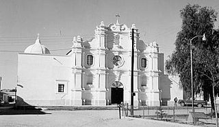
Located in this region are the ruins of the ancient Real de Minas y Villa de Baroyeca, which was one of the most important settlements in Sonora during the colonial period and beginning of the post-independence era.
Ruins of the former missions of Batacosa and Tepahui, founded in the eighteenth century, can also be seen.
The municipal seat, Quiriego, was originally a ranch belonging to Francisco Javier Valenzuela in the last years of the eighteenth century. Quiriego became a municipality in 1932.
Agriculture and cattle raising are the main economic activities. Main crops are watermelon, sorghum, corn, beans, and grasses for cattle raising. There were 34,096 head of cattle in 2000.

Santa Ana is a small city and municipal seat of Santa Ana Municipality in the Mexican state of Sonora. It is located 168 kilometres (104 mi) north of the state capital Hermosillo and 100 kilometres (62 mi) south of Nogales on the United States border. The town had a 2005 census population of 10,593 inhabitants.
Arizpe is a small town and the municipal seat of the Arizpe Municipality in the north of the Mexican state of Sonora. It is located at 30°20'"N 110°09'"W. The area of the municipality is 2,806.78 sq.km. The population in 2005 was 2,959 of which 1,743 lived in the municipal seat as of the 2000 census.

Atil is a small town in Atil Municipality in the northwest of the Mexican state of Sonora. The total area is 400.43 km² and the population of the municipality was 734 in 2005, of whom 699 lived in the municipal seat (2000). Neighboring municipalities are Tubutama, Trincheras, Oquitoa, and Altar.
Bacanora is a small town in Bacanora Municipality in the east of the Mexican state of Sonora. It is located at the geographical coordinates of 28°59′N109°24′W.

Bacerac is a town in Bacerac Municipality in the Mexican state of Sonora.

Bacoachi is a small town in Bacoachi Municipality in the north of the Mexican state of Sonora. The area of the municipality is 487 square miles (1,260.65 km²) and the population was 1,456 in 2005, with 924 inhabitants residing in the municipal seat. The elevation of the municipal seat is 4,429 feet above sea level.

Baviácora is a small town and the municipal seat of the surrounding municipality of the Mexican state of Sonora. The geographical coordinates are 29°42′N110°09′W.
Huásabas is the municipal seat of Huásabas Municipality in the northeast of the Mexican state of Sonora. The municipal area is 711.17 km² (274.58 mi²) with a population of 966 registered in 2000. Most of the inhabitants live in the municipal seat.
San Felipe de Jesús is the municipal seat of San Felipe de Jesús Municipality in the center of the Mexican state of Sonora. It is named after Mexico's first saint and Franciscan martyr, Saint Philip of Jesus.
Opodepe is the municipal seat of Opodepe Municipality in the north of the Mexican state of Sonora.
Moctezuma is a municipio (municipality) of the Mexican state of Sonora, located in the state's central region. It is also the name of its largest settlement and cabecera municipal.

Nacozari de García is a small mining town surrounded by the Nacozari de García Municipality in the northeast of the Mexican state of Sonora.
Ónavas is a small town surrounded by Onavas Municipality in the southeast of the Mexican state of Sonora.

Pitiquito is a small town in Pitiquito Municipality in the northwest of the Mexican state of Sonora.
Tepache is a small town in Tepache Municipality in the east of the Mexican state of Sonora. Its location by GPS coordinates is at: Longitude (dec): -109.528889; Latitude (dec): 29.533333.
Rosario de Tesopaco is a small town, the seat of Rosario de Tesopaco Municipality in the southeast of the Mexican state of Sonora.
Cumpas Municipality is a municipality in the Mexican state of Sonora in north-western Mexico.
Navojoa Municipality is a municipality inthe Mexican state of Sonora in north-western Mexico. As of 2015, the municipality had a total population of 163,650.
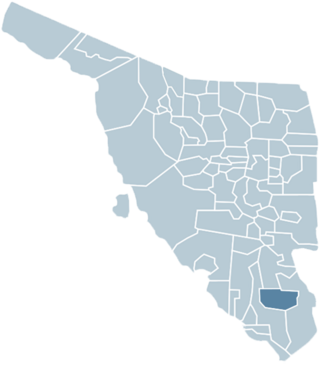
Quiriego Municipality is a municipality of southern Sonora state, in northwestern Mexico.
Rosario de Tesopaco Municipality is a municipality in Sonora in north-western Mexico.